1 April 2018 Brazil to French Guyana (Day 9)
Yet another squall came through just after dawn with torrential rain and 28 knot winds. They’re getting bigger and uglier. Once it had passed through, the skies were grey and unsettled with more black clouds surrounding us. We already had 1½ reefs in the main, so I decided to roll away the main and continue on the broad reach with just the genoa, which is a lot easier to reef in and out
At 07:00, we had 220 miles to go, so if we could average 6.5 knots, we’d make it to the anchorage before dark tomorrow - with a knot of current helping us, there was a good chance. The weather forecast showed similar rainy weather for today and tomorrow, but it looks like it might brighten up the following day.

I had another hard time getting the weather forecast. I sent off my “at sea” blog email and a weather request. Outlook Mail thinks that the emails went okay, but the Iridium server timed out on the incoming emails. The next connection yielded nothing. I re-sent the weather request and finally received the 18Kb GRIB file. It took 4 connections and 9 minutes to get it. There has to be a problem with the Iridium service in this area. It’s annoying that it’s costing me three times as much because their service is bad.
During the morning, the wind decreased and I had to pull the main sail out again. The clouds became brighter and we stayed dry for the rest of the day. We gradually turned downwind as we approached land and by sunset, we were 130 miles from our destination sailing wing-on-wing doing more than 7 knots over the ground - a very good chance of being at Iles du Salut by midday tomorrow.
We had a mixed night. The wind was mostly NE 12-18, sailing on a broad reach, sometimes with the moon and stars shining through breaks in the clouds. At other times, black clouds would overtake us bringing rain and stronger winds. We made good time with a 2 knot current pushing us along at 8-9 knots.
2 April 2018 Brazil to French Guyana (Day 10)
Dawn brought us a miserable day with low clouds scudding across the sky. We’d made good progress overnight and in 24 hours we’d covered 190 miles, which is an average of 7.9 knots - maybe our fastest 24 hours ever. Just before breakfast, a large squall came through with rain for ½ hour and then it sucked the wind away, forcing us to run the engine for ½ hour.
At 10:30, when we were only 6 miles away from Iles du Salut, we were hit by another huge squall system, which gave us torrential rain and veered the wind by 180°. The area around the islands is less than 15 metres depth and I wasn’t sure of the accuracy of the charts, so when the visibility dropped to less than 100 metres, I seriously considered going straight past and carrying on to the Maroni River.

However we decided to push on. When we were 2 miles from our destination, the squall fizzled out, so our first sighting of land was three small islands slowly appearing out of the ghostly gloom. The rain held off as we rounded the south side of St Joseph Island. We briefly looked at the anchorage to west of St. Joseph, but there was a lot of swell, so we carried onto the south side of Ile Royale, which was much better protected.
There’s a short breakwater on the south east corner of the island forming a small harbour with a floating dock and a half a dozen big moorings. The moorings are used by tourist boats that come over from the mainland every day. There were two private yachts on large yellow moorings, which I later found out belong to the Customs and aren’t used very often.
We decided to anchor at 05°17.07N 52°35.36W in 5 metres of water over soft mud. There have been reports that the holding is not good, so we did our normal soft-mud technique of only pulling back lightly on the anchor and then letting the anchor sink into the mud. This seemed to work because we didn’t have any problems. There are some underwater obstructions marked on the Navionics charts, so we made sure that we kept well away.
After lunch, we dropped the dinghy into the water, fitted the outboard and then lifted it up on the davits ready for tomorrow. We then had a well earned afternoon nap. In the evening, we had a curry while watching the classic movie, Papillon, which is all about the notorious French penal colonies of French Guyana including Devil’s Island – one of the three islands that we’re anchored off. The anchorage is a little rolly, but it didn’t stop us getting a good night’s sleep.
3 April 2018 Iles du Salut to St. Laurent de Maroni, French Guyana (Day 1)
Just after 09:00, the tourists started to arrive on large catamarans and were unloaded at the floating dock on Ile Royale. Before following them ashore, we called in at “Kisbar” to have a quick chat with Jean-Marie and Aldo, a couple of Swiss guys, who are heading in the same direction as us. After tying up our dinghy on the inside of the modern floating dock, we walked up to the restaurant at the top of the hill where we picked up some literature and a map of the island.

The islands were part of a penal colony from 1852 onwards for common-law criminals of France. The main part of the penal colony was a labour camp that stretched along the border with Dutch Guiana (present-day Suriname). This penal colony was controversial as it had a reputation for harshness and brutality. Prisoner-on-prisoner violence was common; tropical diseases were rife. Only a small minority of broken survivors returned to France to tell how horrible it was.
Devil's Island and the associated prisons eventually became one of the most infamous prison systems in history. While the prison system was in use, inmates included political prisoners and the most hardened of thieves and murderers. The vast majority of the more than 80,000 prisoners sent to the Devil's Island prison system never made it back to France. Many died due to disease and harsh conditions. Sanitary systems were limited, and the region was mosquito-infested, with endemic tropical diseases. The only exit from the island prisons was by water, and few convicts escaped.
In 1854, France passed a new law of forced residency. It required convicts to stay in French Guiana after completion of sentence for a time equal to their forced labour time. If the original sentence exceeded eight years, they were forced to stay as residents for the remainder of their lives and were provided land to settle on.
The Devil's Island facility was the last to be closed in 1953.
The islands lie directly beneath the trajectory of the rockets launched from the French National Space Centre, which is based at Kourou on the mainland only 9 miles away. Since 1965, the Space Centre has owned the islands and over the past 30 years, they have managed the restoration work and expansion of tourism on the islands.

We were surprised by the size of the restaurant and the number of people staying in the various forms of accommodation. It’s possible to stay in hotel rooms, converted guard’s houses, bunk rooms and there’s designated campsites – not quite the run-down island that we’d expected.
The old buildings of the penal colony are in mixed condition - some have been restored; others have been stabilised, but locked up; and some are just ruins. It was pleasant to walk around the many paths on the island and explore the buildings.
There’s a small museum, which has some interesting paintings of prison life by a previous inmate called Francis Legrange, who also helped decorate the large chapel. The most interesting buildings were the various cells especially the individual solitary confinement cells rooms, where prisoners were incarcerated in total darkness for weeks at a time.
We took the dinghy over to St Joseph Island, where there are more buildings, but there’s no floating dock and the swell was bouncing off the sea wall and ramp, so we decided not to risk ourselves or our dinghy.
After lunch, we decided that we’d seen enough of the Iles du Salut and, as it was a rolly anchorage, we might as well move on. It’s 80 miles to the entrance to the River Maroni, which meant that we had to sail overnight, so I put the dinghy on the front deck and we upped anchor at 16:00.
We motored upwind, going close the west side of Devil’s Island to have a look at (no one is allowed to go ashore). An hour later, we were clear of dangers and in 30 metre deep water, so we turned left and headed parallel to the coast. We had at least 1.5 knots of favourable current, so we only needed to pull out the genoa to sail at 6 knots over the ground.

We were heading for Saint Laurent de Maroni, which is a small town 25 miles up the Maroni River. Ideally, we wanted to be going up-river on a rising tide, so that we could take best advantage of the possibly strong current. Another reason for going in on a rising tide was that if we went aground, we would just need to wait for the tide to lift us off.
Tomorrow’s tides at the entrance were - high tides at 08:00 & 20:20, with a low tide at 14:20. Our initial plan was to sail slowly to arrive at the river entrance at 13:00 and then motor directly up the river. After sailing for an hour, it was obvious that with the strong current, we were going to get to the entrance much earlier.
Rather than struggling to slow down, we continued to sail at a comfortable speed, aiming to arrive at the river entrance at 07:00 – one hour before high tide. We would then have two hours of fairly slack current in the river, which should enable us to get to an anchorage 10 miles upstream, where we could wait for the tide to change before finishing off the last 15 miles.
It was a lovely night sail. The moon came out at 22:00; we had clear star-lit skies and a consistent 15 knot wind. Even with just the genoa, we were sailing along at 4.5 to 5.5 knots, plus we had the 1.5 knot favourable current all night.
4 April 2018 Iles du Salut to St. Laurent de Maroni, French Guyana (Day 2)
Amazingly, we arrived at the outer fairway buoy at 07:06 – only 6 minutes behind schedule. It’s a long time since we last had such a complex channel to follow, but it’s well buoyed with a minimum depth of 2.4m chart datum. The buoy positions on the Navionics charts on our Android Tablet were pretty accurate. The outer fairway buoy was correct at 05°51.80N 53°51.75W. The only major discrepancy is that the critical M2 & M3 buoys are 0.25 miles further north-west than on the charts.

We had a good 15 knot north-east wind, which allowed us to sail all the way into the river. The water was extremely murky, so there was no visual reference for the water depth. The route was complicated by a strong north-west setting current that was pushing us sideways, giving us 20 degrees leeway, so I had to keep looking back at the previous buoy to make sure that we were on track.
At 09:30, we’d entered the main river and were out of the ocean swell. It was now 1½ hours after high tide and we already had 1 knot of current against us, so we decided to anchor to wait for the tide to turn before carrying on the remaining 15 miles. We anchored off the channel at 05°43.7N 53°57.3W in 4-5 metres depth on mud.
We hung around for 4½ hours watching the current, which increased to 2.5 knots even though we were a long way out of the deeper channel, where I guess that it would be stronger. Low tide was at 14:20, so we were expecting the current to slacken off at 13:30 and then turn to push us up the river. At 14:00, we still had 1½ knots of current coming out and only 4 hours of daylight to go 15 miles, so we decided that we had to start heading up the river.
We started to pull up the anchor, but it was caught on something on the seabed. For five minutes, we tried to motor left, right, back, forwards and in a circle, but the damn thing wouldn’t budge. The depth was about 5 metres and the chain had snagged on something at about the 20 metre mark on the chain. I thought about my options. The river was brown with sediment. Even if the current wasn’t ripping along at 1½ knots, I wouldn’t be able to see my hand in front of my face - the prognosis wasn’t good.
For the next ten minutes, we let chain out, pulled chain in, motored around in circles with a growing feeling of doom - would I have to dump the anchor and chain? Suddenly, the chain freed itself and we were able to pull up the anchor - Phew! The anchor had been set in thick mud, but I suspect that there was a rocky patch and the chain had jammed under a rock.

There was a 10-15 knot wind helping to push us up the river, so we let out the genoa and motor-sailed. We had a 2 knot current against us initially, so we were only making 4 knots over the ground. The first five miles was very easy with at least 6 metres of water. The next 1½ miles was tense because the channel goes within 25 metres of the shore line and the depth dropped to 3.2m (2.6m LAT). The channel is supposed to be maintained at a minimum of 2.2m, but hey, we’re in a jungle river.
The remainder of the route was fairly deep and the Navionics charts on our Android Tablet were surprisingly accurate. The damn current stayed against us all the way up river, varying in speed between 1 & 2 knots, so we didn’t arrive in St Laurent De Maroni until 17:30 - one hour before sunset. If we’d simply carried on up the river in the morning, we’d have had deeper water, no trauma with the anchor snagging and it would have probably only took us an hour longer. You live and learn.
It was very choppy in the mooring field because the tide was still going out and the wind was blowing strong against it. We cautiously motored around looking for a spot and were grateful that Roman, who works at the marina, came out to help us tie up. There are no pennants on the moorings, just a ring on top, which is impossible to get hold of from the deck. Our mooring was at 05°30.43N 054°01.85W in 4m LAT.
We collapsed with a cold beer and had an early night.
5 April 2018 St. Laurent de Maroni, French Guyana
The marina consists of about a dozen moorings spread around a bizarre wreck called the SS Edith Cavell. It’s a British cargo ship, which ran aground in the shallow part of the river in November 1924. Over the years, as the river has flooded, mud and silt have accumulated in the wreck and now it is covered by 40 foot trees and jungle plants. It looks just like an island until you look closely and can see the hull sticking up a couple of feet out of the water.
 were made by prisoners")
The marina office is a café at the end of the public floating dock. Roman gave “Kisbar” and us a lift to the Immigration Office, which is at a small ferry terminal about a mile away. It only took five minutes to get our passports stamped. Roman then took us for a quick tour of the small town and then back to the marina, where he filled in and emailed off the relevant form to the customs - a very easy clearing in process.
Glenys and I then walked into the small town to stretch our legs and bought a couple of nice fresh baguettes from the boulangerie. We had a quiet afternoon and then invited Stein & Yvet from “Amuse” over for a few drinks. They’ve just come over from Europe and interestingly went hundreds of miles up the Gambia River - sounds like they had a great time.
6 April 2018 St. Laurent de Maroni, French Guyana
One of the services that the marina offers is a lift to the supermarket at 11:00 every morning. It’s a nice, big Super-U French supermarket, so we were able to restock our French cheeses and luxury items. We dropped off a big bag of laundry at the marina office, which they washed for us, but their drier is broken. Of course, it threw it down for the rest of the day, so we had wet clothes hanging down below and in the cockpit for the rest of the day.
In the afternoon, I did a couple of dinghy runs ashore to get water. The river has so much sediment that we can’t run the water-maker here. The hose leading down to the dinghy dock has been broken by a local pirogue, so I had to lug the jerry cans 100 metres from the café - the cruising life is so glamourous sometimes.
The River Maroni is the border between French Guyana and Suriname. It’s only about ½ miles wide and there is a constant stream of local pirogues heading to and from Albina, a small border town in Suriname. There’s a border control at the little ferry port, but the pirogues land everywhere else, where there’s no immigration or customs. Smuggling is rife and blatant. For example, fuel is a lot cheaper in Suriname, so pirogues bring over 45 gallon drums of fuel, which is loaded into white vans, within sight of the ferry terminal.

We’ve been told that the pirogues also bring pregnant Surinamese women over to St Laurent de Maroni – they time it so that the mother arrives at the hospital already in labour. When the baby is born, it is automatically given French citizenship and the parents can claim benefits. The children are eligible to go to French schools and a large percentage of school children live in Suriname and catch a pirogue over to go to school.
7 April 2018 St. Laurent de Maroni, French Guyana
It absolutely threw it down last night and all day. We were planning to go to the Saturday market, but the gaps between downpours were so short that we gave up and stayed in. Fortunately, we were able to get a decent internet signal on the boat, so we had a relaxing day on the internet and playing guitar.
In the evening, a loud band started playing over by the dinghy dock and it continued after we went to bed - foot-tapping loud reggae mostly.
8 April 2018 St. Laurent de Maroni, French Guyana
The loud music didn’t stop until after dawn, so we were a bit tired in the morning, but thankfully it had stopped raining, so we went for a walk around town. St Laurent de Maroni, was the main landing place for the prisoners coming from France, so we wandered about looking at the old colonial buildings mostly built by prisoners.
On 22 November 1850, Napoleon III declared: "Six thousand condemned men in our prisons weigh heavily on our budget, becoming increasingly depraved and constantly menacing our society. I think it is possible to make the sentence of forced labour more effective, more moralising, less expensive and more humane by using it to further the progress of French colonisation."

The first batch of prisoners left the Breton port of Brest for the Îles du Salut on 31 March 1852. The prison at St-Laurent-du-Maroni was established on the banks of the Maroni River on 21 February 1858. All the prisoners sent from France were taken there before being transferred to other prisons or camps. The town of Saint-Laurent-du-Maroni proper was founded on 16 March 1880; it was a penal town whose inhabitants were nearly all guards or liberated prisoners. The 400 bed hospital was built in 1912, and the prison itself closed in 1946, the same year the whole colonial penal system was abolished.
Our master plan was to have leisurely Sunday Lunch at a nice restaurant, but everywhere was closed because it was a Sunday. Fortunately, the boulangerie was open, so we were able to buy a baguette for lunch. We also bought some Rambutan, which is a fruit from Southeast Asia and very popular in French Guyana – the streets of the town are littered with the discarded outer skin. The fruit has a pleasant, slightly acidic taste which resembles a mix of mango, lychee and kiwi.
It was another miserable rainy afternoon, so I messed about with my guitar and Glenys read a book. We went over to “Amuse” for evening drinks.
We’ve been living on Alba for exactly seven years today, so I worked out a few statistics. In the past twelve months, we’ve sailed 9,832 nautical miles bringing our total to 41,171 since we moved aboard. We’re now at 53 degrees West, meaning that we’ve done 98% of our circumnavigation. In the last year, we’ve run the engine for 440 hours, which at 5 knots equates to 2,200 miles and means that we’ve spent 22% of our time motoring. If you add in the four years that we spent living on Glencora in the 1990s, then we’ve been living on a yacht for ¼ of our adult lives - where did the time go?
9 April 2018 St. Laurent de Maroni, French Guyana
We’ve decided that there’s not a huge amount to hold us here, so we’re planning to leave on the 11th and head directly to St Lucia, which is 680 miles away. Hence, we spent all day running about stocking up on Fuel, Food and Water. It’s amazing how long it takes – we started at 09:00 and poured in the last jerry can of water at 16:30 – almost Miller Time...
10 April 2018 St. Laurent de Maroni, French Guyana
After some heavy showers last night, the rain held off in the morning, allowing us to visit the Prisoners’ Transport Camp.

The prison at Saint-Laurent was a temporary stop for most prisoners. Only a small number of men stayed in Saint-Laurent for long, and they were nearly all employed in the penitentiary administration or were considered harmless and unlikely to try to escape.
When a ship arrived from France, the first order of the day was to separate the ex-escapee and the political prisoners from the rest, to send them to the Îles du Salut, from whose shores escape was considered impossible.
The remaining prisoners stayed for a month or two in Saint-Laurent, where they were put to work building the town while they were sorted into different camps or prisons. The ones considered to be shifty and eager to escape were sent to the islands. The least dangerous men, condemned to prison for petty offences, were offered jobs in the penitentiary administration.
The majority were sent to labour camps along the river, where they were forced to work 12 hours a day in mosquito infested jungle, with no clothes and given very poor rations. Many died and those that did return would have lost 20-30 kg of weight.
Those who were lucky enough to stay in Saint-Laurent were generally better treated than prisoners in other camps. Their work was simple, they were free to go wherever they wanted inside the prison, and were given better rations.

It’s compulsory to join a guided tour, which cost 6 euros, but it was very informative and well worth the money. The tour focused on the prison within the Transport Camp, which had separate sections for political prisoners; unruly or disobedient prisoners; and prisoners who had been freed, but who had broken laws.
Our guide showed us one of the Block Haus, which is where 50 men would be shackled together on concrete platforms as beds. More persistent offenders would be locked into tiny cells, similar to the ones that we saw in Iles Du Salut. They were shackled to the wooden bed and deprived of light for weeks on end.
He then demonstrated the heavy foot shackles by shackling Glenys to one of the beds. The shackle weighs 2 kilograms and depending on the severity of the punishment, the shackle would be placed over or under the leg. When over the leg, the heavy shackle would press on the shin causing severe abrasions and bruising.
We were shown a cell, where Papillon had allegedly scratched his name into the concrete floor during his stay. Our guide also told us about the guillotine and the strange practice of preserving the heads in brine at the local hospital. Apparently, there were 30 heads still there in the 1950s when the prison was finally shut down.
After our tour, Roman took us to Immigration and completed our exit clearance papers, so that we can leave tomorrow. We went and had a nice lunch at the Chez Felix restaurant, where we met up with “Amuse”. They serve a range of “jungle” meat including wild boar and Agouti.

In the afternoon, we did some jobs and prepared the boat for sea. The tides are not ideal because high tide is either at 03:00 or 15:00, so we’re planning to get up and go at dawn.
11 April 2018 French Guyana to St Lucia (Day 1)
The alarm went off before sunrise and we left the mooring just after 06:30, when we could see where we were going. The trip down the river was uneventful, with only the occasional fishermen pulling in their nets. We had the tide with us all the way to the river entrance. During the last ten miles along the approach channel, the tide slowly turned and, by the time that we reached the outer fairway buoy, we had 1½ knots against us. We left St Laurent de Maroni 3.5 hours after high tide, so I guess that the ideal time to leave would have been 2 hours after high tide.
The weather forecast for the next week is for ENE to E winds at 15-20 knots, so with 660 miles on a course of 320°T to St Lucia, we were looking forward to 4-5 days on a beam reach. We started out as expected with the wind 80 degrees off our starboard bow, but as the day progressed, we ended up very hard on the wind - the wind was coming from the North rather than the forecast ENE.
To make matters worse, there were squalls around, which backed the wind by 30-40°, forcing us 30° further west than our desired course. By sunset, we were very frustrated and praying that the north winds were a local, coastal anomaly and that there’ll be better winds as we leave the land behind.

I’m a lazy navigator. Normally, we just point the boat in the direction that will get the boat sailing along the required course over the ground. If we’re sailing downwind, things like magnetic variation, leeway and cross-current effects don’t bother us.
However, while trying to figure out why we were beating upwind, I noticed that our autopilot was set to 345° Magnetic, to achieve our course of 320° True. A bit of calculation figured out the 25° difference. In this part of the world, Magnetic North is 17° west of True North. So our course of 345° Magnetic was 328° True. Add 8 degrees for leeway because we were beating upwind and the mystery was solved.
Overnight, the wind veered about 20 degrees, coming from the NNE, so we weren’t as hard on the wind, but the wind speed increased by 5 knots giving us a bouncy ride with 3 reefs in the main and just the staysail. To make matters worse, there was no moon, so it was pitch black and we had a steady stream of squalls increasing the wind to 28 knots and producing heavy rain. It was a long, tough night.
12 April 2018 French Guyana to St Lucia (Day 2)
The dawn brought us a very dull day – completely overcast with drizzle. While we were having breakfast, a big cloud system passed over us and sucked up all the wind, so we had to motor for 40 minutes. The wind then started to pick up, and within 3 minutes, we were back to 20 knots. The good thing was that the wind had finally veered to ENE, putting us on a beam reach, so life was much more pleasant.

The seas have built up as we head north and, by midday, we had a large 3 metre swell and wind waves from the east. Our course was at 90° to the waves, so it was a rolly, corkscrew motion, but much better than bashing into waves like we did last night.
The day was a blur of cloud systems passing over us. Sometimes we’d have sunshine and 18 knot winds; and at other times, light rain and 25 knot winds. After reefing the staysail many times, we gave up and spent most of the day with 3 reefs in the main and 4 wraps in the staysail, so our boat speed varied between 4 and 7 knots, depending on the wind strength.
Just before dark, we came across a huge patch of Sargassum Weed, which was 100 metres wide and stretched in both directions parallel to the wind as far as we could see. When we entered it, we were lightly powered with a reefed staysail and the thickness of the weed was slowing us down. I had to let out more sail, which was still only enough to keep us moving at 3 knots.
Sargassum Weed normally accumulates in an area of the North Atlantic, known as the Sargasso Sea, where very large mats of the weed form, often many feet thick and miles wide. Early sailors used to believe that Sargasso Sea was a place where ships would get trapped in the weed and nightmarish monsters would prey on the crew. Their ghosts would be doomed to float in the sea forever. We were relieved to break free.
We had clear skies for most of the night, so without the damn clouds, the wind was more consistent at 18-24 knots from the ENE. This was a good fast beam reach, but we had a ½ knot current against us all night. The north-west setting current should be following the continental shelf and now that we’re 150 miles off shore, we must be in some kind of eddy.

During the night, at our changes of watch, the person starting the watch is normally still trying to wake up as they stagger into the cockpit. The person ending the watch passes over information about any weather patterns and sail adjustments.
Having been alone in the dark for three hours, these facts are often embellished with little snippets about the beauty of the stars, etc., which are totally ignored by the semi-comatose person coming on watch. It doesn’t matter which of us is coming on watch, we’re both equally rude.
13 April 2018 French Guyana to St Lucia (Day 3)
We had a lovely start to the day, with a few scattered clouds, but mostly blue skies. The winds were consistent at 18-24 knots and still from the ENE, keeping us on a beam reach. The 3 metre seas are the biggest problem because they’re hitting us side on. Most of the time, we get lifted up and rolled over to port to 30-40 degrees, which means that we have to hang on to something all the time – it’s very wearing.
Occasionally, we’ll get hit by a steep, monster wave, which will slam into the side of the boat, rattling the whole hull and sending a wall of water across the deck. We have our sprayhood up; our side flaps zipped to the bimini; and Glenys has fitted a lee cloth to the guard rails at the windward side of the cockpit. So far (touch wood), these preventative measures have kept the nasty seawater out of the cockpit.
The sun lasted until the afternoon, when the clouds rolled in. However, the wind gradually veered to the East at 18-24, so it was 20 degrees behind the beam, which made the motion a little better, but the occasional roaring wave kept us hanging on.
The clouds cleared around sunset and we had a pleasant night, sailing on a beam reach with 20 knots of wind. Earlier in the day, we’d escaped the counter-current, but it re-appeared and we spent most of the night with 1 knot against us.
We passed a few fishing boats, who didn’t have any AIS. From the sound of the Spanish chatter on the VHF radio, I guess that they were Venezuelan boats. With annual inflation running at 12,000% in Venezuela, I guess that there’s no chance that these fishermen could afford an AIS transceiver, but having to keep a track of their confusing lights makes life a bit more difficult for us.

On my 1-4 watch, I had a close encounter with one of the fishing boats. I was going at 90 degrees to his track, but he just kept on coming straight at me, presumably to come to have a look at us. He passed about 200 metres behind us, which was very stressful because there wasn’t a lot I could do – there’s nothing worse than bored fishermen.
14 April 2018 French Guyana to St Lucia (Day 4)
It was another pleasant, mostly sunny day with 18-24 knot winds varying between East and ENE. There’s still a lot of Sargassum Weed about, but we’ve not encountered any huge mats like a few days ago. However, there was a lot of weed on our decks this morning, so I took a stroll around and lobbed it all overboard. I had to clear out one of our deck drains, which was clogged up with the stuff.
Depressingly, we had a 1 knot current against us all day, but by sunset, it had dropped to half a knot. I’m hoping that the current will be more favourable as we get closer to our destination. At 19:00, we had 165 miles to go, so we’d have to average 6.9 knots to arrive in daylight, which was unlikely. However, it’s no problem to arrive in Rodney Bay at night because it’s a huge open bay.
The good weather continued into the night and, at our 22:00 watch change, we could clearly see the loom of Barbados, 35 miles ahead of us. Our route took us within 15 miles of Georgetown, but after much agonising, we decided to skip Barbados. We’ve read that the only anchorage is Carlisle Bay, which is mostly very rolly and is a hectic tourist destination complete with manic jet skis and pirate ship party boats. Hmmm, I don’t think so.
On my 1-4 watch, I added the final sections to my Alba Owner’s Manual. It’s been a long term project that has occupied my mind on all of the night watches since we left Namibia two months ago. It’s a brain-dump about how we use and maintain all of the equipment on Alba. There’s a lot of kit on a cruising boat, so it’s turned into a 180 page Word document. I now need to edit it and add some diagrams & photos, which will be a little on-going project for the next month.
15 April 2018 French Guyana to St Lucia (Day 5)
When we were directly west of Barbados, the wind dropped to 12-15 knots, so we shook the three reefs out of the main sail for the first time in three days and managed to carry on sailing at 5-6 knots. At 07:00, we were still 90 miles from Rodney Bay, so we resigned ourselves to a night land fall.

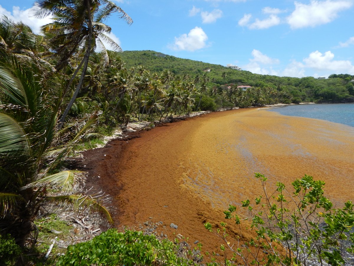
The amount of Sargassum Weed in the sea seems to be increasing as we head north. When I was having my morning constitutional around the deck, I heard a gurgling noise from the stern. I found a huge ball of weed wrapped around the Hydrovane rudder, which took me 10 minutes to get off with our gaff – I think that we were going ¼ knot faster once I had removed the drag.
I’ve read that Sargassum Weed is a huge problem in the West Indies because most of it ends up on the windward beaches of the islands, growing to several feet thick in places. Not only is it unsightly, but the rotting seaweed produces Hydrogen Sulphide, which smells of rotten eggs and, in high concentrations, can be a health hazard. The people who remove it from the beaches have to wear breathing apparatus.
The reason for the Sagassum Bloom is unknown, but the finger of blame is pointing at increased sea temperatures and at nitrogen-rich pollution washing into the ocean from the land, such as sewage waste and fertilizers.
The day remained fine with a steady 15-18 knot wind. We finally picked up a favourable 1 knot current at 16:00, but it was too late to make a real difference. We watched the sun go down over St Lucia and then had a lovely sail around the north end of the island, gazing at the sparkling lights on the houses ashore. It was an easy approach into Rodney Bay and by 20:00, we were safely anchored at 14°04.64N 060°57.66W in 7 metres of water.
We have now completed our circumnavigation of the world. We left St Lucia on the 21st January 2012, so it’s taken us 6 years and 3 months to complete the voyage. We’ve done 40,000 miles, visited 49 countries and had a great time. Our plan now is to get to Trinidad by the middle of June. That’s two months to sail only 220 miles – we’re on holiday.
16 April 2018 Rodney Bay, St Lucia
We had a bit of a lie in, but there’s no peace for the wicked because we had to go to clear in. I dropped the dinghy in the water and attached the outboard, making sure that outboard lock was in place and we had a stainless steel chain to lock the dinghy to any dock - Rodney Bay has a bad reputation for dinghy theft.
The clearance formalities were in the marina and were very straight forward. I went in one door to see customs; through another door to see Immigration and Port Control and then exited by a third door - very organised. The largest amount of time was spent filling in the form - there is an online clearance system called SailClear, but not having any internet yet, I had to resort to the old hand written forms in triplicate.

We had a wander around the marina and the Hardware store outside the gates. Not much has changed in six years. We were thinking of coming into the marina for a couple of nights to wash the boat down, but it’s very expensive (£30/night) and the water is metered. It’s much cheaper for us to be at anchor and run the water-maker for an hour each day
The nearest place to buy a SIM card is at the Rodney Bay Mall, which is a short dinghy ride across the lagoon past the marina. There are a few banks and a reasonable supermarket there too. Fully spammed up with Internet and cash, we dinghied back to the marina and had a fabulous Pizza and Salad with a few beers. After spending the rest of the afternoon sleeping off our lunch, we chilled out in the evening.
17 April 2018 Rodney Bay, St Lucia
We had a chill out day hanging about on the boat. After all the sailing that we’ve done in the past three months, it’s nice to be in a safe anchorage and do nothing.
Even though we’ve created a “For Sale” web site (www.yachtalba.com) and listed Alba on several yacht sale web sites, we don’t hold up much hope in selling the boat privately in the Caribbean - it’s too much hassle for people to fly out just to look at a yacht. We’re pretty sure that we’ll get a much better price in the USA, so the plan is to sail the boat up to the Cheasapeake next year. It’s only 2,000 miles, so it will give us a leisurely 6 month cruise through the West Indies and the Bahamas.

With that decision, we now know that we’re only going to be living on Alba for one more year and that we’re not going to be doing any cruising too far away from chandlers and shops. So, it’s a great opportunity to sort through our lockers and start dumping things that we’ve carried around for the last seven years.
In afternoon, I started in the front cabin and looked through all the various lockers and cupboards - it was very cathartic. I ended up with a bag of stuff to give away; and a bag of stuff that we will be taking back to the UK; and a big bag of stuff to throw away. The saddest item was a Sony short wave receiver that we’ve carried all the way around the world and never used. I’d left some batteries in it, which had leaked, so the radio was junk - ah well.
18 April 2018 Rodney Bay, St Lucia
We had yet another chill-out day and couldn’t be bothered to get off the boat.
Back in June 2016, we bought a new mainsail from North Sails in Singapore, which has always had creases in it when furled. In my opinion, it has been designed and manufactured with too much draft and is very baggy when reefed. Unfortunately, because we’ve been moving a lot, I haven’t been able to get a North Sail loft to have a look at it.
Valentine is the North Sail representative in St Lucia, so I asked him to come out and look at the sail. He agreed with me that the sail is very baggy when reefed, but his sail maker is on holiday at the moment, so Valentine asked me if I could sail over to Marin in Martinique, which is 25 miles away. They have a bigger North Sails loft there and would be able to sort it out for us. We have agreed to go across the day after tomorrow.

“Dream Catcher” arrived from Fernando de Noronha, so in the evening, we went over to welcome them and drank a few beers in celebration of our circumnavigations.
19 April 2018 Rodney Bay, St Lucia
We had another quiet day on the boat - it’s great not to have anything to do.
The situation with the main sail has become a little chaotic. There are three different North Sails offices involved at the moment - St Lucia, Martinique and Singapore where we bought the sail. Valentine in St Lucia has inspected the sail, but hasn’t given any report on what needs doing, so Gavin in Martinique wants to see the sail before he makes any comments.
I’ve been assuming that North Sails will make the modifications under warranty, but Gavin now says that the decision has to be made by Ian in Singapore and they are on the other side of the world and 12 hours ahead us, so there’s a huge lag in me asking a question and Ian replying.
In frustration, I cancelled our trip over to Martinique. There’s no point in spending two days sailing there and back unless the work is going to be done free-of-charge - If I have to pay for any modifications then I’d rather wait and get it done in Trinidad.
With typical West Indies logic, once I told Gavin that I wasn’t going over to Martinique, he told me that he’s probably going to be coming over to Rodney Bay at the weekend and perhaps he could inspect the sail when he’s over here. Why on earth didn’t he say that in the first place and save us two days sailing?
20 April 2018 Rodney Bay, St Lucia
North Sails in Singapore have now come back and have told us that there is no way that any modification work will be done under warranty - the warranty has expired and the sail has done many thousands of miles. I’m annoyed about their lack of customer support, but I guess it’s my fault for not raising the issue while we were still back in south-east Asia. I sent off a “screw-you” email and I’ll never buy from North Sails again.

After five days of slobbing around, we just had to get off the boat, so we caught a local mini bus into the capital city, Castries. I’d forgotten how efficient the buses are. They’re owned by private individuals and they’re licensed to operate on a particular route - the route we used is a round trip from Castries to Gros Islet, which is just past the marina. The minibuses are lined up in Castries and as soon as one is full, it roars off and the next one starts to load passengers. It’s unusual to wait any longer than ten minutes for a bus - brilliant service and it only costs £0.60.
We wandered around Castries, which hasn’t changed much in the six years since we were last here. There are vendors on every street selling vegetables and other local items - it’s a very noisy and colourful place. The old, indoor Castries Market is now devoted to tourist souvenirs, so we didn’t spend too long in there.
After visiting few shops to buy some cheap storage bags and other small items, we had lunch at the Balcony Restaurant which over-looks the central square. Glenys had a Lamb Stew with “Provisions” - breadfruit, yam, plantain, rice, beans and the Caribbean favourite, Macaroni Cheese. I opted for a Chicken Roti, which was lovely - first one for years.
Back at the boat, we upped anchor and headed off to Pigeon Island. There’s usually a big “Jump-up” at Gros Islet on a Friday night, (which lasts all night) and we wanted to get as far away from the loud music as we could.

We initially tried to anchor in 5.5 metres on a light patch of sea bed, but it must have been coral rubble because the chain rumbled loudly as we dragged backwards at an impressive speed. We anchored 50 metres further south at 14°05.40N 060°57.79W in 8 metres of water, which was okay. I snorkelled down to have a look and our anchor is buried in sand, but there are lots of small, 2 foot diameter bommies scattered around. The wind here is very consistent in direction, so I don’t think that the bommies are a problem.
21 April 2018 Rodney Bay, St Lucia
We had a restless night with boat swirling about in a current and squalls coming through. It brightened up in the morning, so we hopped in the dinghy and went to have a look at Pigeon Island, which is an old British fort spread across two hills. There’s a good view of Rodney Bay and in the 1700s, it was a strategic lookout to keep an eye on the French in Martinique only 25 miles away.
After a couple of hours of exercise, the weather was still looking squally, so we upped anchor and moved back to the anchorage off Reduit Beach. We initially tried to anchor closer to the beach at 14°04.553N 060°57.432W in 4 metres of water, but we dragged. I snorkelled down and found the sea bed to be all rubble, rock and small patches of sand. Other yachts seem to anchor here, but we gave up and went further out to 14°04.60N 060°57.52W in 6 metres depth on nice, solid sand.

It rained on and off for the rest of the afternoon, Glenys managed to do a bucket of laundry and some stainless steel polishing in between showers.
22 April 2018 Rodney Bay, St Lucia
I spent the morning writing To-Do Lists. There aren’t too many essential jobs to be done, but there is a long list of small cosmetic chores, which will make the boat more saleable. After 7 years of sailing, there are the inevitable little dents and scratches in the heavily trafficked areas - nothing too bad, but we need to do spend a few weeks doing some varnishing projects.
A lot of the interior chromed items like light fittings and cupboard door handles are showing their age, so I’ve made a long list of “bling” items to buy - there are 25 light fittings and over 30 cupboard latches. Not all need to be replaced, but it’s still going to cost about £500. However, it will drastically affect the first impressions. Fortunately, the upholstery is in excellent condition because we replaced it all three years ago.
It was a miserable rainy afternoon, so I lurked down below doing the miserable job of servicing our two toilets. I managed to complete the back toilet, but I need to buy some spares for the front one.
23 April 2018 Rodney Bay, St Lucia
It’s great to have a hardware store and a chandlery so close to us. We bought spare parts for the toilets, varnish and bilge paint. We’re dumping old spare parts and junk out of our cupboards and filling them up with materials for the various projects to be done over the next two months.
While we’ve been cruising in remote places around the world, we’ve had six 105Ah batteries. A few weeks ago, I found that three batteries had failed on us. I calculate that we use 150 Amps per day when at anchor and 200 Amps per day while at sea (the autopilot sucks up a lot of power).

The Caribbean is sunny and has lots of wind, so I think that we generate 100-160 Amps from the solar panels and 80-120 Amps from the wind generator. This means that our batteries are full for most of the time, so I’ve only ordered one more battery. This gives us 420Ah in total, which will last for nearly three days without any sun or wind, which is fine.
In the afternoon, I finished off repairing the front toilet - at the end of the messy job, I’m pleased to report that our toilets are working better than they have for years. Glenys meanwhile is on a mission to polish all the stainless steel on deck, which is looking very tired after three months and 5,500 miles at sea.
In the evening, we went for dinner and a few beverages on “Dream Catcher”. Martin and Maggie with their crew of Jeremy and Nicole are leaving for Martinique tomorrow and will then be heading off to the Azores next week. They still have 3,700 miles to go until they can put up their feet in La Linea, Spain.
24 April 2018 Rodney Bay, St Lucia
We went shopping in the morning to get some more parts and I picked up our new battery. Back at the boat, I fitted the battery and generally tidied up ready to leave in two days’ time. It was a fairly nice day with light winds, so Glenys jumped in the dinghy and cleaned the stains from the hull, which we’ve accumulated over the last few months.

I’ve been in touch with a Yacht Broker in the USA and he’s suggesting that we should try to get up to the Annapolis Used Boat Show in April next year. I’ve looked at the weather at this time of year and it’s only 50-60 degrees Fahrenheit, which is too damn cold for us. We’re now planning to arrive in the USA in May, when the temperatures should be more civilised. If we start in December, that gives us six months to sail up from Grenada via West Indies, Puerto Rico and the Bahamas - a nice leisurely cruise.
While sipping a cold beer in the cockpit, we watched a stunning sunset.
25 April 2018 Rodney Bay, St Lucia
The plan is to sail to Bequia tomorrow, so we went to the shopping mall to buy provisions. We’ve been having trouble getting cash from the ATM in the Bank of St Lucia. The Scotia Bank at the mall worked ok, but it charged 13 EC (£3.25).
In the afternoon, I cleared out and bought some petrol, which is nice and easy at the marina. We had a quiet afternoon and evening, watching a fabulous Caribbean Sunset.
26 April 2018 Rodney Bay to Bequia, St Vincent
It’s 70 miles between Rodney Bay and Bequia, so we left at 04:30 and motor-sailed along the leeward side of St Lucia and past the impressive Pitons. Once we cleared the south end of the island we were out into 20-25 knots on the beam with 2 metres seas, so it was bouncy roller coaster ride for a few hours.

After 30 minutes of slightly higher and gusty winds in the acceleration zone at the north end of St Vincent, we were suddenly back to motor-sailing in the flukey winds. The channel between St Vincent and Bequia is only 10 miles, but it’s notorious for strong winds, so we motored east along the coast of St Vincent for a few miles to give us a better angle. Our strategy worked and we skimmed past the reef at Devil’s table and sailed into the huge Admiralty Bay.
It was heaving with boats in the anchorage - I would estimate 100 yachts and catamarans dotted around. We anchored off Princess Margaret Beach, which was also crowded. The sea bed is a mixture of good holding sand with large areas of coral rubble. We had a bit of trouble on our first attempt and I snorkelled down to find that we were on coral rubble, but I could see a big patch of sand further ahead. We finally anchored at 13°00.19N 061°14.61W in 7 metres of water - by the time that we’d settled, it was 17:00.
The customs office is open until 18:00 every week day, but they charge overtime if you clear in after 16:00. It’s a bit of a scam because most people will be arriving in the late afternoon. The officers have been known to get really annoyed if you arrive before 18:00 and don’t clear in immediately, but I couldn’t be bothered to try to rush ashore and then have to pay overtime - I cracked open a beer.
27 April 2018 Bequia, St Vincent
We went ashore to clear in and were at the customs office when they opened at 08:30. The officers were extremely polite and didn’t bat an eyelid when I told a little white lie saying that we arrived at 18:30. The clearance process was very quick and only cost $70EC (£18). We have been given a 30 days visa, which is good enough for us.

The shops in the small town were still closed, so we went for a walk around the north side of the bay. Bequia is a quaint little place with brightly painted houses interspersed with breadfruit, mango and banana trees. We walked all the way around the bay and up to the small hill where there is a fortification called Fort Hamilton. There’s a few old cannons and nice view of the anchorage.
Back in town we walked around the few streets and then along the “boardwalk” around the south side of the bay almost to Princess Margaret’s Beach. The town hasn’t changed much. After buying a SIM card and a few groceries, we retired back to the boat for lunch and had a quiet afternoon.
In the evening we went out for dinner at a Pizza place with Howard and Wendy from “xxx”.
28 April 2018 Bequia, St Vincent
We woke up feeling all dynamic and went for a walk towards Bequia Head. We’ve done this walk before and some notes in our hiking section. It was a hot day, so we only made it as far as the quaintly named “Industry” where there’s an old quarry and a small run-down turtle sanctuary.
It was a pleasant walk along a road going past old coconut plantations and a few windward beaches, which unfortunately are covered with Sargassum Weed, several feet thick in places. There’s a nice view of Bequia, when walking back down the hill into town.

I dragged out my dive camera and went snorkelling on Devils Table which is a reef on the northern point of the bay. The water clarity was good and the rocky reef is in good condition with patches of sponges, sea fans and corals. The fish are fairly friendly, but I’ve forgotten how to take pictures underwater.
In the evening, Brett & Mary Pat from “Malaiki”, a Hallberg Rassy 43 came over for sunset beers.
29 April 2018 Bequia, St Vincent
Being a Sunday, we had a chill-out day. I caught up on editing photos and published my blog. In the afternoon, we went across to Devil’s Table for another snorkel.
When we got back to Alba, I discovered that I’ve managed to chip a filling from my front tooth, probably while biting down on the snorkel mouth piece. It’s not sensitive or giving me any pain, which is good news. An old skydiving friend, Tony, repaired the original chip in the tooth back in 1981, so the filling has done a good job. I’ve been in contact with him and jokingly complained about his shoddy dentistry. Tony’s amazed that it lasted for 37 years and offered to fix it for free - sounds like I’ll be having a day of skydiving stories when we get back to the UK...
In the evening, we were invited to “Malaiki” for sundowners, where we met Klaus and Katrin from “Saphir” another HR 43.
30 April 2018 Bequia, St Vincent
Bequia is a nice place, but it’s very crowded and the anchorage has been rolly for the last two nights, so we’ve decided to head off tomorrow. We popped into town to buy some provisions - a case of beer, two loaves of bread, veggies, etc. Port Elizabeth is an expensive place to buy anything because it all has to come over from St Vincent by ferry, so we only bought enough to last a couple of weeks.
We chilled out in the afternoon and had a quiet night.
There are more photos in our Photo Album section.