
Last Updated: 6 September 2016
1. INTRODUCTION
These notes are a result of a 2 month cruise in the Anambas Islands in July and August 2016 on “Alba” our Hallberg Rassy 42F. Our draft is 2.0 metres (6’ 8”). Some of the time we were accompanied by “Amulet” (USA) and “Sea Monkey” (AUS). We visited over 50 anchorages and only met 4 other boats in our time in the area.
Before we visited the islands, I had email conversations with various people who provided information on anchorages and regulations. I would particularly like to thank Captain Warren Blake, who has visited the Anambas Islands no less than 78 times and provided a wealth of information on the outlying islands, including some lovely hand drawn charts. Prakash Reddy at Nongsa Point Marina was also extremely helpful on the regulations for clearing into and out of Indonesia.
If you find any errors in these notes or want to add new information then drop me a quick message using our Contact page and we'll have an email conversation about it.
The latest version of this document can be viewed on line at:
http://www.thehowarths.net/cruising-information/cruising-notes
A PDF version is available from:
http://www.thehowarths.net/cruising-information/downloads
We kept a daily diary of our time in the Anambas, which can be found at:
http://www.thehowarths.net/alba-chronicles/2016-thailand-malaysia
A set of GPX routes and waypoints (which will load into OpenCPN) can be downloaded from:
http://www.thehowarths.net/cruising-information/downloads
A set of KAP charts (which will load into OpenCPN) can be downloaded from:
http://www.thehowarths.net/cruising-information/downloads
2. THE ANAMBAS ISLANDS
The Anambas Islands are a collection of over 200 small islands in the South China Sea, 150 miles east of Singapore. The archipelago belongs to Indonesia and is a Regency within the Riau Islands Province. The main town is Tarempa on the large island of Siantan, where most of the administration is located.

While the Anambas have spectacular islands with white sand beaches and coral reefs, the area has been avoided by most cruising yachts, mostly because of security fears and the problems with administration, especially obtaining clearance in and out of the country.
For the purposes of these notes, we have split the region into four cruising areas - Tarempa, Jemaja, the Central Islands and the Eastern Islands.
3. SECURITY
Cruisers have been avoiding the Anambas for years because of rumours of piracy and reports of hassle from local officials.
While the cruising community acknowledges that the piracy attacks in the region are focused on commercial shipping, targeted at the main shipping route between Singapore and Hong Kong, there are fears that this could spread to attacks on yachts.
In recent years have been a number of acts of piracy in the Malacca Straits and Singapore Straits, where a large number of cruisers already sail. To our knowledge there have been no reports of piracy attacks or boarding of small cruising yachts.

I had many discussions with the local people and officials in the Anambas. The Tourist Office in Tarempa were shocked that cruisers think that the Anambas Islands are dangerous. I talked to the Navy and they constantly patrol the Anambas waters with outposts dotted around the islands. They are mainly concerned with illegal fishing and were unaware of any piracy.
During our various visits to Tarempa, we saw about a dozen armed ships belonging to the coast guard, navy and police. I believe that these are all patrolling the area.
Any hassle with local officials has been resolved with government controls - the customs office even had a large sign saying that customs officers should not be offered tips and the Immigration have a price list prominently displayed. All of the officials that we met were extremely friendly, pleased to see us and there was no suggestion of bribes.
We were woken up by the Navy one night in Tarempa at 02:00. They were very polite and asked if they could come aboard. As we were then awake, we invited them on board and had a long chat. They wanted to see our papers, but I think that they were mostly curious about what we were doing in the Anambas Islands. They also approached “Amulet” who told them to go away and come back tomorrow - they didn’t go back.
The local people and the fishermen were curious about our yachts, but are surprisingly shy (unlike other places in the world.) The small fishing boats will chug past slowly to have a look and a quick wave will be sufficient to receive a beaming smile. When we have shared remote anchorages, the fishermen normally keep a respectful distance and we never felt threatened about being boarded at night. It's nice to go over and have a chat to the fishermen and see if they have any fish for sale. They won't speak any English, so first work out what you're going to say in Indonesian. We were paying 10,000 Rupiah for a fish.
4. FORMALITIES
4.1 Overview
Another reason that cruisers have avoided the Anambas Islands is that obtaining international clearance has not been possible in Tarempa. With the prevailing south to south-west winds in the summer, it would be logical to sail from the Anambas to either Borneo or Tioman, but without being able to clear out, cruisers are faced with a punishing 150 mile slog upwind to Nongsa Point marina to clear out.
In 2016, there were CIPQ (Customs, Immigration, Port Captain, Quarantine) offices in Tarempa in the Anambas. HOWEVER, they are not allowed to do INTERNATIONAL clearances. We have been told that Tarempa will be made into an International Clearance Port in the near future - contact Prakash, the Manager of Nongsa Marina (This email address is being protected from spambots. You need JavaScript enabled to view it.) who will know the latest situation.
***UPDATE NOV 2016 *** Prakash at Nongsa Point Marina has informed me that IT IS NOW POSSIBLE TO DO INTERNATIONAL CLEARANCES BOTH IN AND OUT AT TAREMPA, ANAMBAS. If you go there and do international clearance, can you let me know the procedure and I'll update this section of these notes. ****
We did our clearance in and out of Indonesia at Nongsa Point Marina, Batam, 20 miles south of Singapore. The staff at Nongsa will take the various documents (see below) and obtain an international inward clearance on arrival. The day before you leave for the Anambas, they will obtain the internal domestic clearance from Batam to Tarempa, Anambas. The process is effortless and quick. They charged 500,000 Rupiah (£25) for inward clearance and the same for outward clearance.
There was some confusion when we arrived in Tarempa, but it appears that each of the CIQP offices would like yachts to report in (see below).
The latest regulations can be found on the Nongsa Point Marina web site at:
http://www.nongsapointmarina.com/marina-service-ciqp.php
4.2 Obtaining a Visa Prior to Arrival
If you arrive in Indonesia with no visa, then most nationalities will be issued with a 30 day “On-Arrival” visa.
You can obtain a 60-day Indonesian Tourist Visa in Georgetown, Johor Bahru and Singapore. This involves filling in a form, supplying a passport photograph and paying $35 US dollars. Other documentation is required to support your application (see below). YOU MUST WEAR LONG TROUSERS AND A DECENT SHIRT or you will be refused access to the embassy. In Singapore applications are made in the mornings and pickups are done in the afternoon.
Our friends on “Amulet” obtained their visas in Georgetown and it was much easier than in Singapore.
In Singapore, when the embassy found out that we were travelling by private yacht, they demanded a CAIT and an itinerary of our intended route. They didn’t know that the regulations had changed and sent us to a local Singapore agent. The agent confirmed that we did not need a CAIT and sent us back to the Embassy.
We reapplied, taking along a print-out of a completed Cruising Declaration form which contains a section for an itinerary. We also took along a copy of a memorandum from the Indonesian Marine department informing the Ports of Entry that the CAIT is no longer required. As backup, we took along a recent bank statement showing that we have sufficient funds to buy a ticket out of the country and a copy of our ships registration document.
The embassy staff accepted the Cruising Declaration in lieu of the CAIT and we received our visas 2 days later.
So, we suggest that you go along armed with the following documents:
- The completed Visa application form (download from the embassy you are visiting)
- A recent passport photograph
- Enough cash to pay the $35US dollar fee in the local currency.
- A completed Cruising Declaration form, including an itinerary and make sure that it is signed (a boat stamp probably helps)
- A copy of your ship’s registration document
- A copy of the memo detailing the change of CAIT regulations
- A recent bank statement showing that you have sufficient funds to leave the country.
The visa application form for the Singapore Embassy can be downloaded from:
http://kemlu.go.id/singapore/en/Immigration-Services/Pages/Tourist-Visa.aspx
The memorandum detailing the changes to the CAIT can be downloaded from:
http://www.noonsite.com/images/pdfs/indonesia_no-cait-memorandum/view
4.3 Arrival in Nongsa Point Marina
4.3.1 Introduction
The staff at Nongsa Point will efficiently handle your inward clearance and domestic clearance to Tarempa in the Anambas. We handed over our paperwork and they came back two hours later with everything done.
However, there are some things that you need to do prior to arrival.
4.3.2 Cruising Permit
There is no longer a requirement to have a “Cruising Application for Indonesian Territory” (CAIT). Instead, there is a Cruising Declaration form which should be filled in and printed out before arrival.
http://www.nongsapointmarina.com/download/cruising-declaration-form-2016.docx
4.3.3 Customs
For customs, you can need to fill in an on-line form, no more than 48 hours before you arrive at Nongsa Point marina. You will need to print out a copy of this document to give to customs.
http://yacht.beacukai.go.id/yachtbc/form_mhn_vd_e.php
4.3.4 Immigration
If you arrive in Nongsa Point Marina with no visa, then most nationalities will be issued with a 30 day “On-Arrival” visa.
If you arrive with a 60 day Tourist visa then you will be given 60 days.
4.3.5 Port Captain
There’s nothing special to be done. They issue a Port Clearance document at Nongsa.
4.3.6 Quarantine
There’s nothing special to be done. They issue a Quarantine Clearance document at Nongsa.
4.4 Arrival in Tarempa, Anambas
Each of the CIPQ offices would like yachts to report in.
Port Captain. Their office is next to the Ferry Terminal. Ask for the Syahbandar (“si-ban-dar”), but the sign outside the office is “Kementerian Perhubungan”. They simply stamp the back of the Port Clearance document issued in Nongsa. We believe that this clears the yacht into the Anambas and give clearance back to Nongsa.
Customs. Their office is on the main street. Turn left at the end of the boardwalk from the floating dinghy dock (there’s a model of a customs boat outside). The sign outside the office is Kanto Bea Cukai Tarempa. They took a photocopy of the clearance documents, we don’t think that we have to go back before we leave the Anambas.
Quarantine. Their office is behind two government buildings across the street from the hospital, next to the Tarempa Beach hotel. Turn left at the end of the boardwalk from the floating dinghy dock and at the T-junction turn left then the building is immediately across the road on the right. The sign outside the office is “Departemen Kesehatan”. They wanted a new crew list which they stamped and signed and gave back to us, we don’t think that we have to go back before we leave the Anambas.
Immigration. Their office is on a road parallel to the main street. Turn right at the end of the boardwalk from the floating dinghy dock and after 200 metres take the road to the left that goes over a small bridge. Before the bridge, turn left and the immigration office is on the left. The sign outside the office is “Kantor Immigrasi”. They disappeared with our passports and clearance papers for ten minutes, presumably they just recorded our details.
It sounds a bit complicated, but it’s all very easy. The offices are all within 400 metres of each other and everyone is friendly and laid back - you might find that the officers aren’t there or may be asleep - it’s an island, dude…
4.5 Visa Extension in Tarempa
It’s possible to do a 30 day visa extension in Tarempa. It took Immigration two days to process our application - the major delay was that their internet connection back to headquarters was not working and they couldn’t use the on-line system on the first day.
We extended our 60 day tourist visas by 30 days. We’re not certain if it’s possible to extend a 30 day on-arrival visa, but I don’t see any reason why not.
When we asked for an extension, they initially told us to come back a week before our current visas expire, because the visa extension would run for 30 days from the date that it was issued. We argued that we’d extended last year and the extension had run from the end of the initial visa for a further 30 days. We showed them the stamps in our passports, which convinced them that they could do the same.
So, we entered Indonesia on the 29th June and were given 60 days until the 27th August. We then had 30 day extensions issued on the 26th July and they gave us an exit date of 24th September. The number of days doesn’t quite add up, but it’s nearly 90 days.
The process was as follows:
1. Write a letter to the Kantor Immigrasi, requesting 30 day visa extensions for your crew, put the crew names and passport details in the letter - an official boat stamp would go down well.
2. Fill in an official visa extension form which they will provide.
3. Give them your Boat clearance papers, which they keep hold of for the duration of the process (It would be prudent to get photocopies of the documents before you hand them over.)
4. Pay a fee of 300,000 Rupiah each. Immigration will give you a bill that you have to pay at the BNI Bank on the main street. The teller is upstairs and it was a very fast process.
5. They enter your details into their on-line system - this took 24 hours…
6. They then take your biometric data - photograph, finger prints and signature.
7. Pay a fee of 55,000 Rupiah each. Again, they give you a bill which you pay at the BNI Bank.
8. Wait half an hour for your passports to be stamped with the extension details. (They will give you back your Boat clearance papers.)
5. WEATHER PATTERNS
The weather in the region around the Malaysian Peninsula is dominated by the monsoons. The south-west monsoon begins in May/June and continues to October/November. The north-east monsoon begins in November/December and continues to April/May. There are transitional periods between the monsoons which give variable conditions. The Anambas Islands are best cruised in the south-west monsoon season, when the predominant winds are from the south.

Throughout the year, thunderstorms are common, and sometimes strong. A black squall line might indicate the imminent arrival of a light shower, or sometimes winds of 40 knots or more with spectacular lightning and torrential rain. Fortunately these events are short lived and rarely last more than an hour.
In the two months that we cruised the Anambas Islands (July and August), the weather was very variable although the winds were predominantly from the south. Our first week in July was idyllic with blue skies and 15 knot south-east winds.
For the rest of July and August, the weather was very variable - we had lovely days interspersed by rainy days. The rainy days would start off calm and muggy and then we would see a line of dark clouds approaching from the south west. Within an hour, we would have 30 knot south-west winds and torrential rain for an hour and then the day remained grey and rainy. Interestingly, the pressure seemed to increase by 2mB as the front approached.
While most of the strong winds come from the south-west, occasionally a weather system/squall will pass to the north and with it bring gale force north winds, so make sure that you have enough swinging room and don't "hang" off the north side of a reef.
We had one of these hit us in Pulau Semut South. Dark clouds built to the north and the wind slowly backed to 20 knots from the east. Suddenly the wind backed to the north and minutes later had increased to 35 knots, putting us 30 metres off a lee shore. The gale lasted 30 minutes, then decreased to 20 knots before backing to the west.
If you can get internet access, the Singapore weather radar is useful to show the recent movement of squalls: http://www.weather.gov.sg/weather-rain-area-240km
6. NAVIGATION
6.1 Electronic Charts
We use OpenCPN with CM93 charts and overlays of KAP files that I produce from Google Earth. We also use Navionics charts on our 8” Samsung Tablet and our Raymarine Chart Plotter.
Both the CM93 charts and Navionics charts are very inaccurate in this area, showing very little detail and can be out by up to ½ mile - they are okay for rough planning. (The Navy showed me some photographs of their Indonesian charts which appear to have the same inaccuracies as the Navionics charts.)

Our primary charts are KAP files produced from Google Earth using the GE2KAP utility written by Paul Higgins (http://www.gdayii.ca/). These are very accurate (although some of the satellite images are very low resolution in this area).
I firmly believe that cruising in this area would be impossible without a good set of KAP files or using another way to view Google Earth images off-line. (Our friends on Sea Monkey use Ovitalmap on their iPad, but it is essential to download the images into the application while you have a good wifi connection, before arriving in the Anambas.)
Good sunlight and eyeball navigation is essential practically everywhere.
My KAP files can be downloaded from http://www.thehowarths.net/cruising-information/downloads
A good explanation of how to create KAP files written by Ocelot can be found at:
http://svocelot.com/Cruise_Info/Equipment/KAPFiles.htm
6.2 Tides.
Total Tide has two ports and we found the tidal predictions to be accurate. Navionics and OpenCPN do not have any tidal ports in the Anambas.
I’m not completely sure, but I think that the tidal currents flow south when the tide is ebbing - we certainly experienced this in the channel between Mubur and Matak.
7. CENTRAL ISLANDS AREA
7.1 Introduction
This area has a number of small islands - these are covered from Bawah in the south, heading north.
7.2 Pulah Bawah
Pulau Bawah (02°30.77N 106°02.58E) is the logical first stop on a passage from Nongsa Point because it’s a stunning introduction to the Anambas and the closest secure anchorage, being only 140 miles from Nongsa Point Marina.
UPDATE 2019 - The Bawah Reserve Resort is now fully running. Moorings are charged at US$ 5 net/foot/night and permission to enter the lagoon should be requested 2 weeks before arriving. During periods of high occupancy, the resort will not allow yachts to moor, due to the "privacy and exclusivity of their guests". It's another anchorage closed to cruisers due to the greed of developers.
The alternatives are to carry on a few miles to Pulah Ritan, but it's a tight entrance and only suitable for calm weather. The next option is Pulau Airabu (Kiabu) which is an easy entrance and a safe and beautiful anchorage.
I've left the original pilotage notes in case you still feel the urge to visit Bawah.
The channel into the lagoon has two white buoys, which mark the north and south sides of the passage approximately 15 metres apart - pass between the buoys heading directly east. The channel is at 02°30.728N 106°02.410E and at roughly half-tide the minimum depth that we saw was 4.4m. If the buoys are not present then two way-points for the channel are 02°30.727N 106°02.337E and 02°30.726N 106°02.500E.

There’s an up-market resort which is due to be opened in 2017. There are nine moorings installed by the resort - four white moorings on 4 ton concrete blocks and five orange moorings on 1.5 ton blocks. The moorings are well constructed with chain shackles to the concrete block and substantial rope up to the mooring ball. In 2016, the moorings were in excellent condition, but had no mooring pennants so the ball had to be lassoed and mooring lines threaded through a loop under the mooring ball. There was no charge for the moorings. The lagoon is 18 metres deep on sand (if you have to anchor.)
The owners of the resort are from Singapore and own power boats, so the resort is yacht friendly at the moment, but this may change when a full-time hotel manager is in place. When you visit, be nice, follow their rules and don't screw it up for people following you.
Warren Blake sent me a lovely Hand Drawn Chart of the island.

Hiking. There are some trails on the main island, which are overgrown, but useable - be prepared to climb over fallen trees. We took the path heading west along the beach from the resort’s dock and, just as a board walk started, we continued along the beach (covered in plastic bottles and tar) to a small wood-store hut. We walked through the store hut and found a path leading upwards. The path is indistinct at times and has lots of fallen trees blocking the way, but climbs up the hillside.
After maybe 15 minutes, the path continues up steeply, but there is a large rock off to the right with a smaller path climbing up and around the rock. The path drops down slightly and ends up at a rocky patch overlooking the anchorage - it is a stunning view and well worth the walk up.
We had a Sketch of some Trails on the island produced by Warren Blake, so we tried to continue walking up towards the east side of the island. The trail became non-existent and we were just heading into bush, so not having a compass, we decided to turn around.
On our way down, about five minutes from the beach, we came across another slight trail leading north off the main trail. We walked along that path for half an hour and found some good spots giving us a nice view of the west side of the lagoon, but the trail started to descend, so we gave up and turned around. It was a nice 2-3 hour walk in the bush.
Scrambling. At the north west corner, is a small, but high island called "Watchtower Pinnacle" (02°31.48N 106°02.90E). Land at a small beach on the lagoon side and walk across to the beach on the west side. Follow the beach and then start to climb up in the bus at the side of a rocky slab, gaining access to the slab as soon as possible. Scramble up the slab and turn left at the top, scrambling up a little further until you see an obvious traverse going to the left and up. This is a little exposed, but the rock is very grippy and mostly solid - I did it in a pair of Teva sandals. Watch out for loose rocks on the way up. Once at the top the view is fabulous.

Snorkelling. The snorkelling is fair in most places within the lagoon, but the water is cloudy. The visibility is very good outside the lagoons, but obviously exposed to wind and waves. There has been extensive fishing with explosives. This was the only place that we saw Blacktip Reef Sharks - look for babies in the shallows on the beach The best snorkelling spots that we found were:
- Just off the resort dock on the drop off in the large lagoon;
- Outside the reef, south of the entrance channel at 02°30.56N 106°02.34E
- Outside the reef at the southern tip of the atoll at 02°29.95N 106°02.81E
Scuba Diving. We couldn’t find any prime scuba diving spots, but the southern tip of the atoll may be an option in settled conditions.
Later, a government reef survey team told me that the diving is good off the east tip of Pulau Sanggar at about 02°30.25N 106°03.29E. They told me that there's a sign saying “134” on the island where the dive is located. The current can be very strong at this location, so pick your time carefully.
7.3 Pulah Ritan
Pulau Ritan (02°36.94N 106°16.57E) is another stunning anchorage. The entrance is across a 25 metre wide fringing reef with 2.5 to 4 metres of depth with shallower coral heads dotted about. Once in the lagoon, there are two sandy patches where it's possible to anchor in 6-8 metres between reefs, with only enough swinging room for one boat on each sand patch. The centre of the lagoon is 18-20 metres deep and I assume that it will be sand. This would be an alternative spot to anchor for a third boat or to be away from the reefs in unsettled conditions.

The approach should only be attempted in good light conditions as you WILL be dodging coral heads. The route that we took in and out was:
- 02°37.082N 106°16.512E
- 02°37.031N 106°16.539E
- 02°36.990N 106°16.538E
The middle waypoint goes between two very shallow coral heads (about 15 metres apart) and we made a 30 degree course correction as we went through the middle. When we left, we had a 1.3 metre tide and the minimum depth that we saw was 2.5 metres.
We anchored in 6 metres at 02°36.90N 106°16.57E, the anchor was buried in good holding sand and we had 30-40 metres swinging room between the reefs, which was okay for settled conditions.
Ashore. The beach is okay, but typically covered with garbage. Scrambling up the rocky slabs at the south-west side of the anchorage is great fun and gives a fabulous view of the anchorage. "Sea Monkey" shared the anchorage with some fishermen from whom they bought some Tuna for dinner.
Snorkelling. The water visibility is poor on the reefs by the sandy patches, but there is a good diversity of fish. The reef next to the entrance is patchy, but the water is much clearer. We didn't try any spots outside the reef.
Alternative Anchorages. Nearby Pulau Ritan North (02°38.01N 106°17.73E) is a small island with a sandy patch to the west of the island, but it’s exposed to the wind and swell from the south-east - we didn’t stop. Fishermen were camping on the beach when we were there.
7.4 Pulau Airabu (Kiabu)
Note. Pulau Airabu is called Kiabu on some of the local maps.
Pulau Airabu South (02°44.25N 106°14.76E) is one of our favourite anchorages. It's a very well protected anchorage in depths of 8-12 metres on sand nestled next to some shallow reefs. It is protected from all directions except east to north-east. The small islands on the south-east tip of Airabu give good protection from the prevailing south-east wind and waves.

There are two channels to approach this anchorage - one to the north-east of a small island called Lintang and the other to the north west of Lintang. Both have depths more than 8 metres, but there are shallow reefs that need to be avoided, so good light is recommended. An alternative approach is further north of the small islands and should be okay, but we never went this route.
Lintang North East channel was mostly deep with a few shallow reefs and we passed close to a small island, which looked interesting, but the only anchorage is on the south side and exposed in the current winds. Our waypoints were follows:
- 02°43.315N 106°17.031E
- 02°43.703N 106°16.466E
- 02°43.810N 106°15.996E
- 02°44.167N 106°15.576E
There are shallow reefs at 02°43.641N 106°16.695E; 02°43.659N 106°16.358E)
Lintang North West channel was straight forward in good light with depth of over 8 metres. Our way-points were follows:
- 02°43.25N 106°14.61E
- 02°43.34N 106°15.23E
- 02°43.49N 106°15.44E
- 02°43.74N 106°15.46E
- 02°44.10N 106°15.27E

Ashore. We walked up some of the rock slabs to the north of the anchorage. Most of the shore line is protected by mangrove trees, so we left the dinghy at bottom of the slab that reaches the water at 02°44.43N 106°14.79E. There is no path, so you have to beat your way through the undergrowth.
You should take a compass because the terrain is confusing. We didn't have a compass and ended up on the other side of the headland and then had to work our way back west to get to the top slab, which turned the short jaunt into a 2.5 hour epic. It's well worth the effort because the view is fabulous.
Snorkelling. The small reefs next to the anchorage are fairly interesting and the sand flats have some creatures if you look - I saw a Banded Snake Eel and some interesting Tube Anemones. We tried the reefs in the Lintang North West channel but they were very patchy coral - perhaps more out to sea might be better.
We snorkelled at the north side of the channel around 02°43.71N 106°15.30E and found that the shallow reef was in good condition and colourful, but the deeper parts not so good.
7.5 Pulau Airabu - Potential Anchorages
We did a circumnavigation of Airabu, looking for other anchorages with the following results (we didn’t anchor in any of them):
Airabu East 1 (02°44.892N 106°14.965E). Anchor in 12 metres - looks to be clear with a sandy bottom. Nice looking anchorage off a beach with steep cliffs around. It seems sheltered from any south-east swell. We didn’t attempt to anchor.
Airabu East 2 (02°45.10N 106°14.90E). A large,deep bay with mangroves at the end and steep cliffs over-looking it. The depth dropped slowly to 18 metres, then there was a wall of reef blocking the bay. A yacht could probably get over the reef, but there doesn't seem to be any large clear sandy patch to anchor in. Best to anchor in Airabu East 1 and explore by dinghy. We didn’t attempt to anchor.
Airabu East 3 (02°45.599N 106°14.543E). A small, pretty bay at the south-west end of a larger bay. The bay is mostly over 30 plus metres deep with 5-8 metre reef patches closer in (02 45.78 N106 14.62E). There's a sandy area with depths of 7-12 metres in between coral patches - it looked tight to us. The anchorage has two moorings put down by fishermen. The bay seems to be susceptible to swell from the south east which hooks around into the bay. The corner is better protected than the main bay. We didn’t attempt to anchor.
Airabu East 4 (02°47.010N 106°14.054E). A nice bay with a beach and rocky cliffs. There is a sandy shelf, which slopes from 30 metres to a shallow fringing reef. It would be possible to anchor in 12 metres on sand in settled conditions. We had a south-east, swell which made the anchorage uncomfortable and a lee shore. We didn’t attempt to anchor.
Airabu East 5 (02°47.284N 106°13.868E). The water shelves rapidly from 30 metres to a fringing reef. There is a 12 metre spot where one could anchor, but not in a south-east swell. Another pretty spot. We didn’t attempt to anchor.

Airabu West (02°46.28N 106°12.75E). At the north end of the bay, there’s a small village with a mosque and a huge telecom aerial, but no internet access.
The bay looked very good on Google Earth and the charts showed the depth slowly shelving to the head of the bay, which has mangroves. This normally indicates a nice sand/mud bay and good anchoring. But, not this bay. It was over 25 metres deep and then shelved quickly to a fringing reef at 4-5 metres deep, about ¼ mile from the shore.
We crossed the reef hoping to find a sandy lagoon behind, but when I dropped the anchor in 12 metres of murky water at 02°46.052N 106°13.109E, we heard an ominous rumbling on the chain - coral. Our chain became wrapped around coral heads and it took ten minutes to free it. “Amulet” tried further towards the shore, but dragged in a patch of very soft mud and couldn’t find anywhere better.
We then tried to anchor on the south side of the bay in 24 metres next to a small beach at 02°45.87N 106°12.55E, but it was still coral on the sea bed. We gave up and returned to Pulau Airabu South via the west coast and the Lintang North West channel.
Scuba Diving. If you can find somewhere to anchor, a reef survey team told me that there is a very good wall dive off the north coast of Pulua Gembili near 02°45.83N 106°10.33E.
7.6 Central Region - Potential Anchorages
North of Airabu is a group of small islands - Mengkait, Temiang, Udgung, Lubang Tamban and Telibang. We sailed around these islands, exploring potential anchorages with the following results:
Pulau Mengkait (02°54.51N 106°08.11E) - This is being promoted by the tourist office as a place to visit where it’s possible to lodge in a “Home Stay”. It’s a very small island with quite a large village and scores of small fishing boats on moorings at the north east side. Interestingly, the island has a Christian church and most of the villagers are Christian. The water around the island is over 30 metres deep, so we didn’t attempt to anchor.
The nearby islands called Pulau Temiang and Pulau Udgung don't appear to have any suitable anchorages - the sea bed seems to be at 35 metres rising rapidly to a very shallow fringing reef.
Lubang Tamban (02°57.98N 106°09.52E) - We found a spectacular little bay on the west side with four lagoons/pools, but they are all protected by reefs. After crossing the first reef with a depth of 5 metres, we found a lagoon that was 12 metres deep, but it was only 50 metres in diameter and too tight for us to anchor. A great shame because the colours were stunning. It would be possible to anchor outside the fringing reef in deep water.
7.7 Dekar Reef (Dikar)
Dekar Reef (03°00.16N 106°08.17E) is a pretty anchorage on a 6 metre deep sand shelf between the reef and the deep channel between Dekar and Telibang. The colour of the water is stunning and this makes a very useful lunch stop or could be an overnight stop in very settled conditions. It is exposed from the south-west through to the north-east.
Snorkelling. The snorkelling is okay on the reef on the fringes of the sandy area.
7.8 Pulau Telaga North
PulauTelagaNorth (03°05.545N 105°58.010E) is a very nice anchorage at the north end of Pulau Telaga. There’s a shelf of sand at a depth of 15-20 metres, next to the fringing reef. At the edge of the shelf, the sea bed drops off quickly from 20 metres to over 30 metres. The anchorage area is roughly 200 metres long and 100 metres wide and there’s space for 2 or 3 boats. The holding is excellent in white sand, but the anchorage can be rolly and is open to the north and south.
Alternative Anchorage. It would also be possible to anchor in the channel to the east at 03°05.34N 105°58.42E, which has a similar, but smaller sandy shelf.

Ashore. There’s a small fishing village with 100 inhabitants about ¾ mile to the south, so be prepared to be visited. We traded a diving mask for a Wahoo with guys from one of the large fishing boats that anchor off the village.
We visited the very friendly village (Telaga Kecil) and had a pleasant two hours being shown around by an entourage of children and some adults. They have a junior school and extensive gardens stretching over the hill to a beach on the west coast.
Snorkelling. The snorkelling on the reef at the edge of the anchorage is good and varied. We tried around the headland to the north, but the sea bed is very rocky. We spent half an hour snorkelling next to the large cave in the cliffs which appears to be home to many swallows. The snorkelling was average, but we did see a huge shoal of hundreds of Greenthroat Parrotfish. “Amulet” reported that the snorkelling around the rock at 03°05.64N 105°58.49E was good.
Scuba Diving. As the south wind was quite strong, we took the dinghy across the channel and anchored in the shelter of a small headland at 03°05.71N 105°57.80E. We descended to 22 metres and turned south following the bottom of the reef. There was a lot of sediment and small jellyfish in the water, but the hard and soft corals were in very good condition.
When our tanks were down to 100 bar, we headed up to 12 metres and returned to the dinghy. We spotted a couple of nudibranchs and some fabulous Soft Corals. It was a surprisingly good dive. I suspect that the other side of the channel at 03°05.72N 105°58.05E will be as good.
7.9 Genting Unjut
Genting Unjut (03°09.241N 106°05.360E) This is a pleasant looking anchorage off a nice looking beach. There’s a sandy shelf at 6-8 metres depth, but it looks tight between the fringing reefs. Alternatively could anchor in 18 metres off the sandy patch.
7.10 Pulau Durai
Pulau Durai. (03°20.38N 106°02.83E) This island is a nesting site for hundreds of turtles. Until recently, the turtle eggs were harvested for human consumption, but the island is now a marine park and the turtles are being actively protected. It’s about 12 mile to the north-west of Tarempa Town.

It’s a challenge to find a good, protected anchorage because the island is mall and the reef is deep. After looking at a few places, we opted to drop our anchor at 03°20.42N 106°02.76E in 28 metres - this is on the north side of the island, giving us a little protection from the prevailing south winds. I snorkelled down to check the anchor and we were anchored in coral rubble and sand, just outside the main fringing reef. We were a little close to a reef which sticks out from the north tip of the island, so it might be better to anchor a little further east at 03°20.38N 106°02.83E.
Ashore. The best beach to land on is on the east coast. There were dozens of tracks of large turtles coming out of the sea to lay their eggs and hundreds of smaller tracks made by the baby turtles returning to the sea. It’s a pretty beach apart from the tonnes of plastic rubbish that litters the sand.
At the south end of the beach, there’s a track leading up over rocks through the trees. This path leads down to another beach on the south of the island, which also has lots of turtle tracks and more plastic. There’s a small settlement of a few houses at the edge of this beach, where I believe people live who are helping to protect the turtles. There was nobody around, but we saw a small hatchery protected by chicken wire.
Scuba Dive. We anchored our dinghy at 03°20.40N 106°02.66E in 10 metres to the east of a large rock awash. The area where we were anchored is a huge area of coral stretching for hundreds of metres. The water is very clear and the coral is very pretty and healthy.
We headed north-east for 100 metres and then descended a coral covered slope to 24 metres, where the sea bed was coral rubble and sand. (At this point, we could see Alba above us.) We stayed in the deeper water for ten minutes and then returned to investigate the flat reef at 10 metres, which was much more interesting. It was a nice dive; we saw a huge shoal of Golden Spadefish, but no turtles.
8. TAREMPA AREA
8.1 Introduction
This area includes the major town Tarempa plus numerous other villages. The area to the north has some great anchorages. You can also anchor off the “Air Terjun Temburun” waterfall, which is a major tourist attraction in the area.
8.2 Tarempa Town
Tarempa (03°13.148N 106°13.151E) This is the administrative and commercial centre of the Anambas Islands. It’s a pleasant town with lots of small shops where you can buy a wide range of items.

The anchorage is at the south-east corner of the harbour alongside a long causeway built on concrete pilings. The depth is mostly between 20 and 25 metres with shallower patches of coral - watch your depth sounder carefully and look for a smooth patch.
The best place is as close to the corner as you dare, which is clear, firm sand. We anchored at 03°13.06N 106°13.14E in 10 metres, which seemed to be good, but only one boat will be able to get this spot.
We’ve anchored here twice in 22 metres, with multiple failed attempts due to dragging on rubble and picking up a huge plastic sheet with our anchor. We also dragged when a squall came through with 45 knot gusts - we only had 60 metres of chain out in 22 metres depth and it wasn’t enough. We also snagged our chain on coral in one place and had a problem pulling the anchor up.
It sounds grim, but if you check the depth carefully and avoid any shallow patches, when anchor is set the holding can be okay. It’s worth letting the anchor settle into the mud for 30 minutes before backing it in.
It’s worth persevering because the town is nice and the people are friendly.
Dinghy Dock. In 2016, there was a small floating dock at 03°13.027N 106°13.151E, which belongs to the Navy. A boardwalk from the dock leads to the Naval building, which has a sign saying “Lanal Tarempa”. The dock is used by an official boat, but they are quite happy for you to use it for your dinghy. Tie up to the east side and try to keep it close to the sea wall (we sometimes put out a stern anchor).

In Town. From the dock, a boardwalk leads to the main street. With the Naval building in front of you, turn left to find the Customs and Quarantine offices. Turning right will take you into the main town, where you will find the Immigration and Port Captain Offices.
Tarempa is a bustling little town with narrow streets packed full of small shops selling a huge variety of items from clothing to motorbike parts and dried fish to plastic bowls. This is the largest commercial centre in the Anambas Islands and all the outlying villagers buy things from here. Hardly anyone speaks English, but we got by with our poor Bahasa Indonesia.
A useful contact is Axel who you will find at the Sakura Inn, which is 100 metres from the dinghy dock. It’s the first large three-storey white building on the right as you walk into town. Axel speaks very good English; is very helpful and knows where to buy anything in town. His email address is: This email address is being protected from spambots. You need JavaScript enabled to view it.
The tourist office is slightly out of town just past the fish market. They don’t have a lot of information, but Mayang Mustijah speaks good English and is very helpful. You can contact her before you arrive on This email address is being protected from spambots. You need JavaScript enabled to view it. or This email address is being protected from spambots. You need JavaScript enabled to view it., she’ll help you with any official problems.

ATM. There are several banks on the high street and we used the ATM at the BNI Bank several times without any problems.
Petrol (Bensin). You can buy petrol at many of the small shops in town. They supply the fuel in 1½ litre plastic bottles for 14,000 Rupiah per bottle. There’s a small shop right next to the Naval building at the end of the walkway from the dinghy dock, which is convenient.
Diesel (Solar) You will probably be approached by some of the water taxis, who can supply diesel for 10,000 Rupiah/litre. We didn’t use this facility as it was expensive. I suspect that they would deliver the fuel in 30 litre containers.
“Amulet” walked to a fuel supplier who is directly to the west of the big mosque. It's a small stall on the corner selling petrol, next to the archway that crosses the road. They sell the diesel for 7,000 Rupiah/litre. “Amulet” bought 200 litres of fuel and they arranged to have the fuel delivered directly to their boat. They gave the boat driver 50,000 Rupiah.
We contacted the Anambas Lodge (This email address is being protected from spambots. You need JavaScript enabled to view it. or +62 821 1412 0632). They sell diesel for 7,500 Rupiah/litre. You moor on their wooden dock, which is located at 03°13.62N 106°14.35E with depths of 6-8 metres alongside. The dock is strongly constructed out of wood, but is rough and has large truck tyres as fenders. We tried in vain to use our fenders to hold ourselves off the tyres, but gave up and resigned ourselves to 15 minutes work removing black rubber marks from our topsides.
The diesel is supplied in 30 litre containers. The workers at the hotel will pour the diesel in for you, but you need your own filter funnel (or pump). They are fairly careful when pouring the diesel, but expect a bit of a clean up job when they've finished. The fuel is dark, but fairly clean - we only had a few bit of debris left in the filter.
Water. Desalinated water is available in several places in town. They will deliver to the dinghy dock if you buy a lot.
Laundry. There’s a laundry just past the big Mosque. They also provide Desalinated water. Laundry takes two days for wash and dry.
Day Trip. It’s possible to hire motorbikes - just ask around. We hired two from a small motorbike workshop near the bridge. It cost us 50,000 Rupiah per day plus 14,000 Rupiah for fuel. It’s a pleasant ride to the Air Terjun Temburun waterfall, but when we got there, the waterfall was just a trickle.
Snorkelling. The water in the bay is surprisingly clear and I had a pleasant few hours poking around under the causeway.
Souvenirs. There’s a place where they sell material and clothes made from locally fabricated batik cloth. It’s located next to the tennis court and the sign says “Dharma Wanita Persatuan”. We think that it’s some sort of association for women run by the Regent’s wife. They have a range of products including some T-shirts. The place is often closed, so you have to persevere.
8.3 Anambas Lodge
Anambas Lodge (03°13.643N 106°14.386E) This is a favourite anchorage for the small (power boat) rallies that come from Singapore once a year. Anchor in 22-25 metres in front of the resort. The hotel has a wooden dock with plenty of depth, so it’s possible to moor alongside. They can supply substantial amounts of diesel, but need a couple of days’ notice (see above).
The resort is very quiet and two miles from Tarempa town, so we didn’t anchor there.
8.4 Air Asuk
Air Asuk (03°14.687N 106°17.464E) This is a fishing village that is being promoted by the Tourist office as a place to visit. There is a secondary school here and the headmistress is reported to speak good English and is friendly. The anchorage is in 10 metres in the channel between the island and a reef. It’s good holding, but the current makes the boat swirl around. We only anchored there for a few hours at lunch time.

The village was very quiet when we were there.
8.5 Tarempa to Air Asuk
The route from Tarempa to Air Asuk passes through or around an extensive reef system.
Route 1. The shallow draft local water taxis go through the middle of the reef system. There are navigation posts to follow, but the route passes close to (and over) some shallower reef patches. The waypoints for the passage are shown below, but maintain a good lookout for shallow patches.
- 03°13.63N 106°15.30E
- 03°13.35N 106°16.04E
- 03°13.35N 106°16.40E
- 03°13.31N 106°16.60E
- 03°13.34N 106°16.78E
- 03°13.44N 106°17.10E
- 03°13.64N 106°17.24E
- 03°13.91N 106°17.30E.
Route 2. An alternative route is to keep to deep water (15 metres) and skirt around the south of the reef system. This adds about a mile to the route, but in poor light might be safer. The waypoints for the passage are shown below, but maintain a lookout for shallow patches, especially near the end.
- 03°13.63N 106°15.30E
- 03°12.63N 106°16.20E
- 03°12.50N 106°16.70E
- 03°12.72N 106°17.17E
- 03°13.03N 106°17.26E
- 03°13.91N 106°17.29E
8.6 Temburun Waterfall
Temburun Waterfall (03°10.63N 106°16.77E). This is a pleasant anchorage near Tarempa's "major" tourist attraction. There's a large village ashore. The anchorage is a little way out from the village, but gives a nice view of the Temburun Waterfall. Anchor in 13 metres of good holding sand at 03°10.63N 106°16.77E.

The approach into the anchorage is a little torturous, but it's easy to see the shallow reefs in good light. The way points are:
- 03°11.317N 106°17.300E
- 03°11.219N 106°17.201E
- 03°11.050N 106°17.097E
- 03°10.897N 106°17.050E
- 03°10.680N 106°16.812E
Ashore. There's a concrete dock at 3°10.63N 106°16.48E - go around the two small fish farm nets nearest to the anchorage and the dock will become apparent. The locals use a stern anchor and tie the bow of their small boats to the dock, so it's best to do the same with your dinghy. There are a few small shops with very basic provisions.
Waterfall. The tourist literature says "Standing a magnificent 250 meters high, Temburun's relentless flow cascades down a total of seven separate levels before tumbling directly into the swirling sea below - a spectacular sight!"
There's a wide path leading up from the main road to the middle of the waterfall. From the dock walk up to the main road and turn right. The path is about 50 metres on the left. It runs parallel to the road for 25 metres then climbs some steep concrete steps. The upper part of the waterfall is more spectacular than the lower half, so it's worth the grind up the hill.
8.7 Pulau Semut North
Pulau Semut North (03°23.121N 106°17.386E). This is one of our favourite anchorages. It’s at the south-east corner of Semut island in 12-15 metres on good holding sand. There are many reefs surrounding the anchorage, but most seem to be 10 metres deep - there’s probably room for 3 or 4 boats, if some anchor in deeper water.
It’s a pretty spot, with two beaches with swaying coconut trees and a very shallow pass between the islands, giving beautiful blue colours. It’s well protected except from the east and very popular with the local fishing boats - some evenings, we had up to ten small fishing boats anchored around us, but most of them go out fishing a few hours after dark.
Snorkelling. There’s a reef alongside the anchorage to the south, which has some interesting coral heads at a depth of 4-10 metres, but the water is full of particles. We had a look on the north-east side of Semut Island, where the water was much clearer, but it’s mediocre, rocky reef at depths between 6-12 metres, which gradually slopes deeper.

Scuba Dive. We anchored our dinghies in 6 metres of water at the south side of the anchorage (approximately 03°23.070N 106°17.428E). We headed north down the reef until we met the sand at about 17 metres. Turning east, we followed the edge of the reef until we had used half of our air and then ascended to 10 metres returning to the dinghies.
The visibility was very poor (5 metres) where we anchored the dinghies, but improved dramatically as we headed east out of the channel. When we turned around the visibility was 20 metres, so it might be worth starting the dive further east. The coral is in good condition although everything is covered by a fine layer of silt. It was a reasonable dive considering the conditions and I spotted my first Tomato Anemonefish, which are localised to this region.
A couple of weeks later, we did a second dive here, going a little further east than last time (I guess at around 03°23.09N 106°17.54E), just off a small headland. The reef is 10 metres deep for a long way, so we found the edge of the reef and anchored on the nearest coral pinnacle.
We headed north to the drop off and descended to 22 metres following the edge of the reef east. After a while we ascended to 12 metres, retraced our steps and then played around on the 10 metre reef which is pretty. The visibility was very good, but there were lots and lots of long particles in the water. The shallower reef is more interesting than the deeper. We saw a small Common Lionfish - the first we’ve seen in the Anambas.
8.8 Pulau Tenggiling
Pulau Tenggiling. (03°22.692N 106°13.989E). A lovely white sand patch around 6 metres deep. Good holding, but exposed to south winds. “Sea Monkey” anchored here in settled weather for a couple of days and loved it.

We anchored here for 30 minutes in a south 25 knot wind (as a large system went over) and it was a very uncomfortable lee shore with 2 foot wind waves that built up quickly - we moved 2 miles south to Pulau Mubur NE. We returned the following day when it was sunny and calm, and the anchorage was transformed to a beautiful place.
Snorkelling. “Sea Monkey” tried snorkelling in various places in eth area and said that that the snorkelling was best around the small island directly south of the anchorage. We spent an hour snorkelling on the north-east side of the island and found it to be good.
Scuba Diving. “Going Easy Too” said that the reef to the to the north-east of Pulau Tenggiling (near 03°23.10N 106°13.98E) dropped away steeply and may be a good site for a scuba dive. We didn’t have time to investigate.
8.9 Pulau Mubur North
Pulau Mubur North (03°23.04N 106°13.48E). This was reported by a yacht on the 2015 Malaysia Rally as a good anchorage in about 17 metres on sand and coral, with a a white sand beach nearby.
When we investigated, the light was so poor that we couldn’t see the reefs and there's plenty of them. We didn't stay.
8.10 Pulau Mubur NE
Pulau Mubur NE. (03°20.79N 106°13.59E). This is a pleasant, deep bay with a stream at one end of the beach and coconut trees stretching up the hill. The bay faces north, which gives excellent protection from south winds (we had over 25 knots and heavy rain when we arrived). The snorkelling is mediocre, but there’s a good 2-hour hike from the beach and Long-tailed Macaques forage on the reef at low tide.
The water in the bay gradually reduces from 35 metres to 18 metres and then more quickly down to 5 metres. The fringing reef narrows quickly the further you get into the bay.

On our first visit, we dropped the anchor in 7-8 metres in between two edges of the fringing reef. We let out 25 metres of chain and settled back to a depth of ten metres, but were a little too close to the side reefs for comfort. It was a calm evening, so we stayed there. The sea bed is soft, muddy sand. The following day, we did a small survey and found that the water shelves more slowly at around 20 metres going deeper.
On our second visit, we anchored at 03°20.79N 106°13.59E in 20-22 metres of water - it seemed to be soft mud/sand, so we let the anchor settle for 30 minutes before backing it in. We felt that this was a better place to anchor.
Snorkelling. We tried snorkelling in three separate places in the bay and found that the coral was in poor condition, either from blast fishing or storm damage.
Ashore. There’s a beach at the head of the bay, with a pleasant coconut palm grove. A faint path goes through the coconut grove and climbs up the east side of the valley above the bay. The path is used by locals to gain access to their plantations/gardens higher up and is obvious for most of the time, although it sometimes disappears into the undergrowth. At one point we lost the path next to an isolated triangular shaped rock - the path turns left just before the rock. If in doubt turn left.
It takes about an hour to walk up to a ridge at the head of the valley, where you can see down to the villages on the southern side of the island. You will pass several small huts that the local farmers use for day shelter. The crops grown include coconut, banana, chilies, papaya, taro and a few Durian trees. It’s a nice, if strenuous 2 hour hike. (I suggest that you take a stick and watch out for snakes - I nearly stood on one on the path.)
9. JEMAJA AREA
9.1 Introduction
Jemaja is a large island to the west of the Anambas Archipelago. There are numerous anchorages and small islands around the coast. There’s a small town at Letong. The anchorages are detailed from the north east corner heading anticlockwise. The anchorages on the west coast are affected by the prevailing south to south west swell and can be rolly.
9.2 Pulau Ayam
Pulau Ayam (02°59.53N 105°48.43E) This is a great anchorage - very well protected and pretty. The anchorage is 8-12 metres deep on a large sandy patch in front of a reef fringing a beach and a reef in the middle of the bay - the south edge of the reef is at 02°59.57N 105°48.43E. There’s enough room for a dozen boats. Approach Waypoints are: 03°00.11N 105°49.26E; 02°59.60N 105°48.58E
Snorkelling. Snorkelling on the eastern tip of Pulau Ayam island is okay with some good healthy coral. We tried several spots around the anchorage including the reef in the middle of the bay and the shallow reef in the pass heading west, but both were uninspiring. The shore of the mainland to the east of the anchorage was even worse being just rock.
We went to the north-east side of Pulau Ayam and anchored in the second bay at around 03°00.28N 105°48.79E. There’s a rock awash at the east side of the bay, which is an impressive pinnacle dropping down to 12 metres. The snorkelling was the best that we found in the area, but mostly rocky reef and the visibility was poor.

“Amulet” visited the small island called Pulau Penanan (03°00.57N 105°50.23E), but the snorkelling there was nothing to write home about.
Scuba Diving. Most places that we looked at were gradually shallowing rocky reefs and we felt we could see as much snorkelling.
We saw an Indonesian survey team diving on the North-west corner of Pulau Ayam at 03°00.54N 105°48.25E. They were checking the condition of the reef. I chatted to them, but because of language difficulties, I’m not sure about the quality of this dive location.
Other Potential Anchorages. A big, steel catamaran () anchored at 03°00.09N 105°48.10E in 15 metres of water, which gave them more swinging room - not sure what the sea bed was like.
Navigable Passage. When leaving the anchorage heading west, “Amulet” took a passage between Pulau Ayam and the mainland of Jemaja. The minimum depth that they saw was 5 metres, although a good look out needs to be kept for isolated coral heads. The waypoints are:
- 02°59.56N 105°48.56E
- 02°59.70N 105°48.54E
- 02°59.75N 105°48.41E
- 02°59.84N 105°48.32E
- 02°59.94N 105°48.25E
- 03°00.03N 105°48.13E
- 03°00.09N 105°48.04E
9.3 Tukan Bay
Tukan Bay (02°58.49N 105°46.94E). This is a lovely anchorage and a well-protected bay. The sea bed gradually slopes from 15 metres to 7 metres and has a sandy sea bed. There are a few isolated reef patches around the anchorage. Closer in (towards the white sand beach lined with coconut palms), there is a fringing coral reef. When we were anchored here, there was a swell hooking into the bay and making it a little rolly at times.
Snorkelling. We snorkelled at the north-eastern tip of the bay, which was good, but exposed in the strong winds. The reef at the middle of the west side of the bay was more interesting with varied coral and some large fish. We saw a turtle just by the drop off.
9.4 Padang Melang
Padang Melang. (02°59.63N 105°43.76E). This is the best anchorage in Jemaja, just off a small village in a huge bay with a 3 mile long white sand beach. The anchorage is in 5 metres of water over firm white sand, which is a blessing in the Anambas Islands. There is enough room for more than 50 yachts to anchor here.
Ashore. Padang Melang is a neat and tidy village and is geared up for tourists with Palapas dotted along the edge of the beach and even showers dotted around. However, there were no tourists in sight and the few small Warangs (restaurants) were closed at lunch time. As usual in the Anambas, the locals were very friendly and helpful. A nurse (Yanti) stopped to chat to us and she arranged for us to borrow two motorbikes to explore the island.

Road Trip. We drove to Letong, which is a 10 minute ride from Padang Melang (about 2 miles). From the beach, head south and follow the concrete road over a bridge and then turn right at a small store selling petrol. In 800 metres, you will arrive at a roundabout, where you bear right into Letong. (See the Letung section for more information)
We visited the Air Terjun Neraja waterfall which was pleasant. It’s about one hour’s motorbike ride through some lovely countryside and a few small villages. If you turn left at the roundabout, the nice new road turns rougher and passes through a rice growing area. You come to a kind of T-junction, where you should turn left and go up the hill past some official looking buildings on the left.
After that just keep going along the narrow road and eventually you will enter a small village with a disproportionally large road sign at a cross roads pointing left to Air Terjun Neraja. The road become progressively worse until it peters out at a steep dirt path heading up. Park your bike and follow the dirt path for 200 metres to the waterfall. (Back at the crossroads, there’s a very small Warung at the crossroads where we had a basic, but tasty Mee Goreng.)
Eating out. We ate at a good, local Warung late one afternoon - they open at 15:00 (I think). It’s 400 metres from the beach. Follow the road towards Letung and just as you pass under a new archway, the small Warung is on the left. As an appetiser, we had a local delicacy called Gong Gong, which was interesting and tasty. It’s a small shellfish, which they boil in heavily salted water and serve with a very hot chili sauce. The main courses depend on what they have on the go, but the Bakso was very good. (You might have to ask for Gong Gong - there’s no menu that we saw.)
Snorkelling. The isolated rocks 1.5 miles to the north-east of the anchorage are interesting. Mostly rocky reef with coral, but there are some interesting structures especially to the east of the biggest rocks. Not many big fish, but we did see a nudibranch and a fairly large carcass of a lobster, so keep your eyes peeled.
Alternative Anchorage. At the south-east end of the bay, the sea bed shelves slowly and would be better protected from any strong south east winds. However, there’s two large stone piers for unloading gravel from barges for the new airport, so it’s not very attractive.
9.5 Passage to Kembung Bay
It’s possible to follow the coast when heading north and stay inshore of the outlying islands (it saves about a mile). It’s mostly deep water, but there are some shallow reef patches around 03°00.31N 105°44.33E, so keep a good eye out.
- 03°00.03N 105°44.21E
- 03°00.31N 105°44.33E (Reef Patches)
- 03°01.01N 105°44.55E
- 03°01.82N 105°44.53E
9.6 Kembung Bay
Kembung Bay. (03°02.32N 105°44.10E) Anchor in 12 metres of water on sand, close to the fringing reef. It’s a very pretty spot, but the anchorage was exposed to the strong 20-25 knot south winds that we had, so we only stopped for lunch. If staying overnight, you could anchor further away from the reef in 18 metres.
9.7 Jemaja North 1
Jemaja North 1 (03°02.09N 105°43.32E) "Amulet" anchored here for two nights in 17 metres between reefs. Good shelter from south winds. There’s a small village ashore, but they didn’t visit it.
9.8 Jemaja North 2 (Possible)
Jemaja North 2. (03°02.87N 105°43.96E) A small, rather exposed anchorage - some swell was coming around the corner when we visited - we didn’t anchor here. It’s difficult to get in close to the pretty beach because of the fringing reefs, so you’d have to anchor in 15-18 metres of water.
9.9 Pulau Impul Kecil
Pulau Impul Kecil (03°04.83N 105°43.73E). Anchor in 7 metres of firm white sand. It’s a very pretty anchorage next to a small island. Unfortunately, it’s very exposed to the south winds, so may not be suitable for overnight, but it makes a fair day stop in 20 knot south winds. There’s a large and shallow reef (with rocks awash) at about 03°04.64N 105°43.67E.

Ashore. There’s a large village with a big mosque. We did not visit.
Snorkelling. The snorkelling is good around the exposed rock at 03°04.64N 105°43.67E. There are some impressive large plates of coral and many large fish.
Cave. There’s a cave about ½ mile around the east side of Pulau Impul at 03°05.10N 105°44.10E. It goes back for about 40 metres - you can swim into the cave, but it’s not particularly exciting. The snorkelling outside the cave is average.
Later, a Reef Survey team told me that there's another cave underwater further around the island - not very far past the visible cave. There is a very obvious number "4" painted onto the rock above the cave. Apparently, the entrance to the cave is at 10 metres depth and it goes back for at least 25 metres - dive torches are essential.
Alternative Anchorage. We think that it would be possible to anchor in 22 metres in the middle of the bay at 03°04.98N 105°43.39E, but it would offer only slightly more protection from southerly winds.
9.10 Pulau Anak
Pulau Anak. (03°06.64N 105°40.36E) Friends on “Anthem” reported that there is a good anchorage in 6 metres on sand. Unfortunately, inclement weather kept us away from this anchorage.
Scuba Diving. A government reef survey team told me that there is good scuba diving to the north of either of the two small islands to the north of the anchorage at roughly 03°07.66N 105°39.97E and 03°07.62N 105°40.46E. We didn’t have time to dive these locations.
Alternative Anchorage. Google Earth shows that there seems to be a good looking anchorage at 03°06.33N 105°38.59E. However, we didn’t get a chance to visit this place.
9.11 Pulau Kusik Laut
Pulau Kusik Laut (03°03.79N 105°41.50E) This is a very pretty looking bay and the headland looks like it could be interesting snorkelling or diving. The light was poor when we had a look at this anchorage and the space between the fringing reefs looks narrow. We didn’t anchor. It may be possible to anchor in 20 metres, but we’re uncertain whether the sea bed is coral or sand.
9.12 Djutan North
Pulau Djutan North (03°01.34N 105°41.72E). This is an interesting little anchorage on white sandy bottom in 6-8 metres, tucked up behind a little island. There’s room for a couple of boats. Unfortunately, SW swell enters this anchorage, so it's a fair weather anchorage only. We didn’t anchor here.
9.13 Djutan Bay
Djutan Bay (03°00.54N 105°41.37E). This bay has good protection from the south winds and is a good alternative to the anchorage at Letung if the weather is bad. “Amulet” anchored here in a 40 knot south-west squall. Anchor in 20-23 metres, which looks to be sand between the usual fringing reefs. There is a village ashore which is about ½ mile from the main town of Letung.
9.14 Passage - Pulau Ipan
It’s possible to go between Pulau Ipan and the mainland with 15 metres of water. The waypoint for the middle of the passage is 03°00.57N 105°40.39E. If there’s a strong wind from the south, then there can be large standing waves, which make heading south a challenge.
9.15 Letung Town
Letung (02°59.39N 105°41.32E) This is the main town of Jemaja. The bay is facing south-west, so the only protection from the south winds is tucked behind a small island called Pulau Berhala in 20 metres of water. We arrived soon after a big 40 knot squall and the anchorage was very “sloppy” with south to south-west swell curving around the edges of the small island.
The current is quite strong when the tide comes in and out, so the boat veers around and can be side-on to the wind for hours. Combined with the waves hooking around the island, this can make it a bouncy anchorage. It’s probably a nice anchorage in settled conditions, but when the weather is unsettled, there are better places to be.

Dinghy Dock. It’s a bit of a challenge to get into town. There are a lot of shallow reefs to negotiate and if you go into the market in the early morning, then the sun will be directly in your eyes.
The safest way is to follow the deep water approach used by the local cargo boats. From the anchorage, head on a bearing of 115°, leaving the cargo dock 200 metres to your left and aim for a green navigation pole, 0.8 miles away at 02°59.00N 105°42.01E. Leaving the green pole to starboard, turn onto a bearing of 050° and head towards a large building on stilts (02°59.25N 105°42.29E), which is a collection of restaurants to the left of the two large telephone antennae. Watch out for shallow reef on the way in.
There’s a Large Dock on the south east side of the restaurant, where you can safely tie your dinghy probably between coastal cargo boats. The dock has strong, horizontal wooden planks (with no nails) which are fairly easy to climb up.
From the dock, it’s a short 100 metre walk to the market area.
Ashore. The town of Letung is spread out a mile along the main road, which follows the coast. There’s a kind of town square on the main road and most of the shops and the market are located to seaward of the square.
The market is based on a road parallel to the sea front. It opens very early and is finished by 09:00. You can buy fish, squid, frozen chicken and fresh vegetables, but the range is somewhat limited. There are many small shops selling a range of other products, including some hardware.

The town has a number of tourist guest houses and restaurants, which all seem to be built on stilts out towards the sea. However, we saw no white tourists and it is likely that locals will approach you to have their photo taken with them.
9.16 South of Letung
Google Earth shows that there are a couple of potential anchorages at 02°56.15N 105°42.13E and 02°55.18N 105°40.56E, which might be worth exploring. Unfortunately, when we were in the area, the weather was unsettled with a south-west swell, so we never visited them.
9.17 Camp Kuku (Possible)
Camp Kuku . This is a tourist destination with a little bit of history. We're not sure what the anchorage is like in the bay at 02°52.97N 105°41.95E - the Google Earth images aren't too clear, but it may be possible to anchor in between coral reefs.
During the Vietnamese refugee crisis in the early to mid 80's, Camp Kuku was one of the islands used by Indonesia to house the Vietnamese boat people, who were fleeing their country en masse. A total of 40,000 refugees were retained at Camp Kuku and to a lesser extent on Pulau Air Raya. Regrettably, not everyone made it off the island. For this reason, Kuku still exerts quite a draw to those who spent time here as a refugee, as well as, in some cases, to their children and grandchildren.
9.18 Kampung Kuala (Possible)
There’s a village on the east coast called Kampung Kuala at 02°54.39N 105 48.23E, where there may be a sheltered anchorage in 10-15 metres in the narrow bay in front of the village. We never visited this bay.
10. EASTERN ISLANDS
10.1 Introduction
There are well over 50 islands in this area, which could could occupy you for weeks. The anchorages that we found are described from the north to the south.
10.2 Air Asuk to Eastern Islands
To get out to the Eastern Islands, there’s a deep channel through the reefs from Air Asuk. The waypoints for the passage are shown below, but maintain a good lookout for shallow patches.
- 03°13.90N 106°17.29E
- 03°13.95N 106°17.63E
- 03°13.99N 106°17.85E
- 03°14.09N 106°17.96E
- 03°14.22N 106°18.04E
- 03°14.22N 106°18.35E
- 03°14.19N 106°18.71E
- 03°13.92N 106°18.86E
- 03°13.93N 106°19.00E
10.3 Pulau Tading (Possible)
Pulau Tading (03°14.234N 106°18.780E) This is on the way out to the eastern islands and it looks like it’s possible to anchor in 20 metres well away from the reef. This is a pretty beach with a well maintained wall - perhaps somewhere the locals go at weekends? We didn’t anchor here and not sure of the name of the island.
10.4 Pulau Penjalin
Pulau Penjalin. (03°23.54N 106°26.84E) This is a great anchorage in a channel between two small islands (Nibung and Setuju) in depths of 14-18 metres over sand. There are many reefs surrounding the anchorage, but most seem to be 10 metres deep. Our anchor slammed into the soft sand, so we felt happy with only 45 metres of chain out giving us a small 3:1 scope and we weathered a few squalls with 30 knot gusts. The anchorage is exposed from north-east to south-east, but this was no problem when we were there.

Potential Anchorage. There’s a sandy patch at 03°23.60N 106°26.60E, which is 10 metres deep with access over the deep reef from the north. It would be possible to anchor there, but it’s very tight with only 50 metres between the reefs and it doesn’t give any better protection than the place where we anchored.
Potential Anchorage. There’s a beautiful looking sand patch at 03°22.94N 106°26.54E off the beach, which may be a lovely anchorage for shallow draft catamarans. Unfortunately, we didn’t have a chance to investigate and find out if there’s sufficient depth to get over the reef and in the anchorage.
Potential Anchorage. Warren Blake told me that he's anchored at 03°22.55N 106°26.72E in 20 metres, but it didn’t look good to us.
Channel. There’s a narrow channel between the two islands, Penjalin Besar and Penjalin Cecil. The channel was easy to navigate in good light with a minimum depth of 10 metres.
Waypoints through the channel are:
- 03 22.3523 N 106 26.4016 E
- 03 22.5671 N 106 26.5073 E
- 03 22.6964 N 106 26.6222 E
- 03 23.1754 N 106 26.8831 E
Snorkelling. The locals rave about this being a fabulous place for snorkelling, but we tried various places, but didn’t find anything special. The reef has been heavily bombed and while there is new growth of coral, the seabed is only made interesting by the various coral heads and boulders.
We found it interesting close to the shore of Pulau Setuju at 03°23.85N 106°27.011E - snorkelling in between the massive boulders. There were some large fish here including several Titan Triggerfish, but they kept a long distance from us.
Scuba Diving. This is supposed to be one of the best scuba diving areas in the Anambas. We looked at various sites around the islands, but couldn’t find any places worth getting all the scuba gear out. Most spots were gradually shallowing rocky reefs and we felt we could see as much snorkelling.
Later, a government reef survey team told me that the diving is good off the north-west tip of Pulau Penjalin Besar at 03°23.72N106°25.95E - we didn’t have time to try it.
The same survey team also told us that the diving is good off the reef on the south east side of Penjalin Cecil around 03°22.15N 106°27.62E - we didn’t have time to try it.
10.5 Pulau Mandriau (Mandanan)
This is a nice island with several potential anchorages. The locals also call this island Mandanan.
Pulau Mandariau Bay (03°18.348N 106°24.219E) This is a lovely anchorage in a bay at the north side of the island. There’s a big patch of white sand, which is 10 metres deep between shallower reefs, with enough room for four boats. The reefs around the anchorage are good with healthy coral.

Pulau Mandariau West (03°18.306N 106°23.467E) It looks like it’s possible to anchor in 10 metres between reefs. The sea bed is sand, but we didn't anchor here. It’s an attractive anchorage.
Pulau Menjali (03°18.284N 106 23.253E) It looks like it is possible to anchor in 13 metres off the small island of Menjali to the west of Mandriau. The seabed is sand, but we didn't anchor here. Nice looking beach and island.
Snorkelling There’s great snorkelling here. We looked along the north-west shore of north-west tip of Menjali, a small island a mile or so to the west of the anchorage. The sea bed was a huge expanse of rock with boulders near the shore and patchy coral in the deeper water. It’s not as pretty as a coral reef, but we like to check out different environments and spent a happy 30 minutes there. Glenys found a dozen large Tiger Cowries hidden in cracks in the flat rock surfaces (alive, so she left them) and I spotted a Nudibranch called a Pimpled Phyllidiella.
We tried in several places along the north shore of Menjali, but it was very rocky until we entered a small bay further south, which was okay coral. We landed at the beach at the south east end of the island, which is lovely soft white sand, but there weren’t any shells worthy of collecting. It would be nice to anchor off this beach in 12 metres on sand away from the fringing reef.
The best snorkelling is just to the north of the anchorage near 03°18.56N 106°24.29E. The reef is very pretty at depths between 5 and 10 metres. Lots of small fish and a few nudibranchs if you look carefully.
Scuba Dive There’s a pleasant scuba dive nearby - we anchored our dinghies on a large coral head at 03°18.570’N 106°24.257’E (It’s about 70 metres south of a rock that is awash near the shore). We descended to 8 metres and then headed west, descending a coral slope to 22 metres. Following the edge of the reef and the sandy sea bed, we headed north until we had used half of our air and then ascended to 12 metres, returning to the dinghy.
It was a nice dive in clear water. There aren’t many large fish, but enough to look at. We saw a Sky Blue Phyllidia and there are some very pretty coral patches. Some areas of the coral slope have been extensively bombed, but there are signs of recovery. There is a small cave at 12 metres depth directly west of where we anchored the dinghy.
10.6 Moon Rock Lagoon, Pulau Sagu Dampar
Moonrock Lagoon (03°14.90N 106°26.71E). This is another stunning anchorage, protected from three sides by islands with white sand beaches. This spot was recommended by Warren Blake who sent me a lovely Hand Drawn Chart of the lagoon. The main island has a very impressive rock bluff overlooking the anchorage which gives the Lagoon its name - named by his crew because the Moonrock Bluff loomed bright in the moonlight. It's well worth scrambling up to the top of Moonrock Bluff for a fabulous view.

The entrance is a little tricky, having to weave through a few reefs for 200 metres, but with good light there is no problem because the narrow channel is very deep. The waypoints for the channel are:
- 03°14.996N 106°26.507E
- 03°14.960N 106°26.577E
- 03°14.964N 106°26.631E
- 03°14.927N 106°26.695E
Once through the entrance, the lagoon opens up and is about 200 metres in diameter with depths of 10 to 14 metres on firm white sand. We anchored at 03°14.90N 106°26.71E in 13 metres.

Ashore. You have to climb to the top of Moonrock Bluff. We landed the dinghy on a tiny little patch of sand directly beneath the Bluff; then headed east for 25 metres and then up a rocky gully. There isn’t really a path, so we climbed more or less straight up the hill, chopping down small branches with my machete and skirting around the numerous fallen trees. We reached the bottom of the bluff and followed the eastern edge of it until we came to the top after 25 minutes.
What a view. You can see for miles - the anchorage looks stunning and the colours are gorgeous. It’s well worth the strenuous climb.
Snorkelling. The water within the lagoon is cloudy and the reef covered with a fine layer of sediment. The reef to the north east of the anchorage is navigable in a dinghy and the snorkelling at the other side at around 03°15.14N 106°26.96E is good with clear water and some interesting coral formations.
Scuba Diving. A reef survey team told me that the diving was good on the east side of the island to the north of the lagoon. We investigated by snorkelling and there's a steep rocky wall, then rocky reef at about 15 metres slowly descending to about 25 metres. The reef looks to be in good condition, with some large fish around. Anchor the dinghy at 03°15.33N 106°27.03E. This is a bouncy lee shore in strong winds. We didn't get to dive this spot.
10.7 Hilton Pool, Pulau Sagu Dampar
Hilton Pool (03°14.54N 106°26.23E). This is another anchorage recommended by Warren Blake, who sent me another lovely Hand Drawn Chart of this anchorage. Unfortunately, when we visited the area, we had strong SSW winds and the anchorage was untenable.
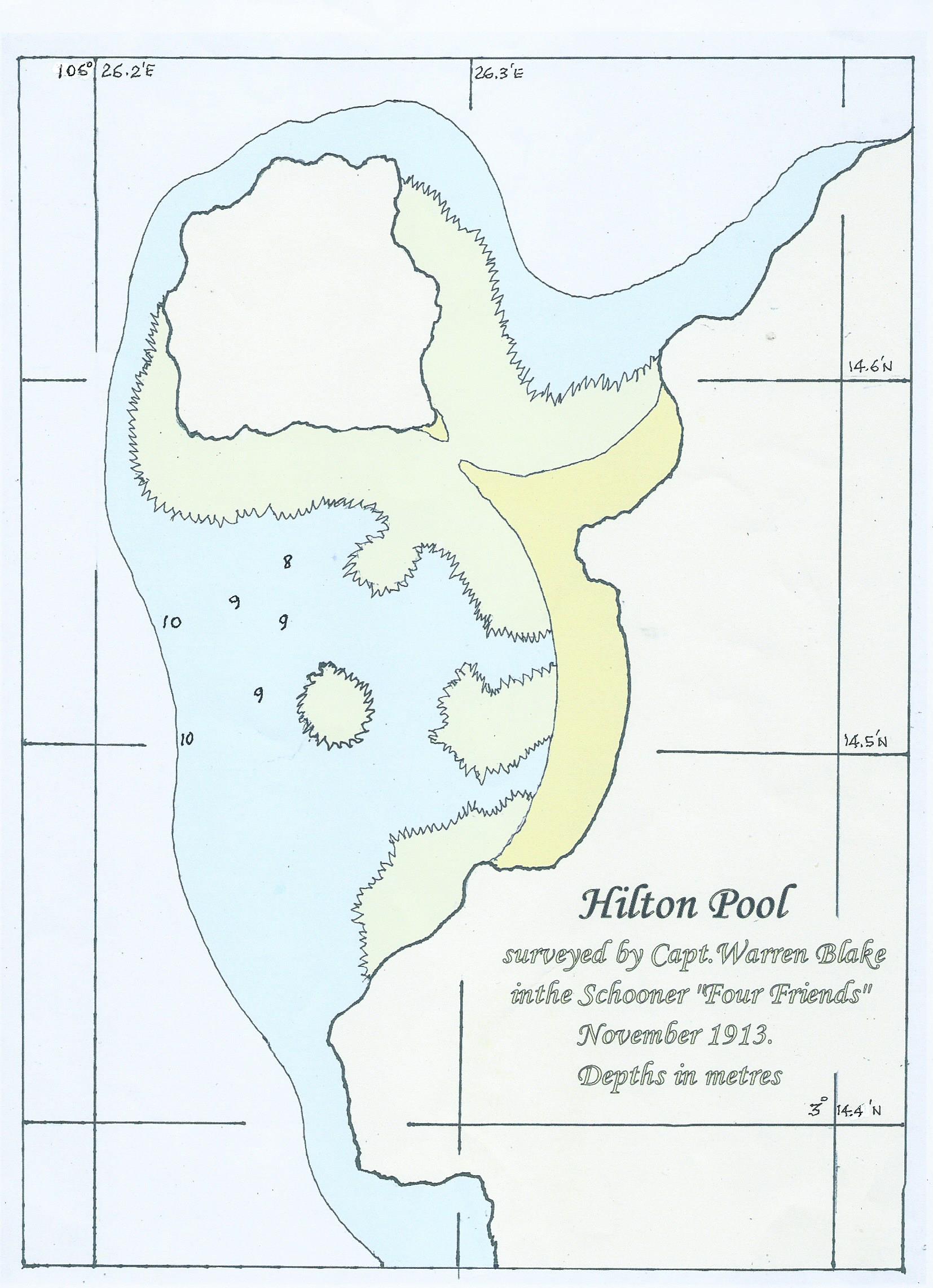
10.8 Pulau Selai
Pulau Selai (03°12.20N 106°29.30E). This is a well protected bay, with a rocky coast line, but no beaches. We anchored in 17 metres on good holding sand, with enough room for maybe two boats between the reefs. There's a shallower sandy patch closer to shore used by small fishing boats, but not much swinging room. We only stopped for lunch.
Snorkelling. We didn't stay long enough to do any snorkelling, but there are some isolated rocks off the headland on the east side of the bay, which might provide good snorkelling or diving at 03°12.38N 106°29.79E
10.9 Passage between Selai and Penilan
The narrow passage between Palau Selai and Pulau Penilan is navigable with at least 16 metres depth. The way points are:
- 03°12.723N 106°28.999E
- 03°12.457N 106°28.763E
- 03°12.233N 106°28.566E

10.10 Pulau Pengedung
Pulau Pengedung (03°09.37N 106°23.934E). This anchorage is on a 10-14 metre deep sand patch alongside the fringing reef and there's room for half a dozen boats. With a rocky coast line and no beach, it's not particularly impressive, but it is very well protected from the prevailing winds and is very close to Pencil Dot Island, which is only 1/2 mile to the north.
Snorkelling. The water visibility is below average around the anchorage, but the reef is healthy.
10.11 Pencil Dot Island (Pulau Selat Ransang)
Pencil Dot Island (03°09.90N 106°23.80E). This island was named by Warren Blake because the island is the size of a pencil dot on the charts. It's only 200 metres long, but is a perfect uninhabited tropical island - a white sand beach; coconut palms swaying in the breeze; rocks to scramble on; and surrounding corals reefs. It's such a small island that it offers very little protection. We didn't anchor there, but visited by dinghy from Pulau Pengedung. We measured the depth of the sea bed off the beach on south-east side which is 12-15 metres deep - it looks like sand, so would be a good lunch stop or an overnight in settled conditions.
Ashore. There's a nice white sand beach and some high rocks on the south-west side that are fun to scramble on.
Snorkelling. The water visibility was below average and the coral is unexciting in the shallows. There was better coral and lots of small fish, next to the drop off.
10.12 Sandspit Island (Pulau Temeruk)
Sandspit Island (03°09.53 N 106°25.61E). Another anchorage named by Warren Blake - the island is actually called Pulau Temuruk. There's a lovely white sand spit leading out to a small, pretty island. It's a little exposed to the prevailing southerly winds, but it's a gorgeous spot in settled conditions. We anchored on a sandy patch at 03°09.53 N 106°25.61E in a depth of 9 metres. There's enough room for 2 or 3 boats.
Ashore. There's a nice long beach, which is fairly clean at the south end, but the plastic garbage builds up as you head north. There's a substantial wooden hut with benches at the south end of the beach. At the north end of the beach is a coconut grove with lots of brown coconuts and sprouting coconuts, which are good enough to gather - there are obviously no rats on this island.
Snorkelling. The water visibility was below average and the coral is unexciting, although there are a surprising number of Anemonefish in the shallows.

10.13 Pulau Pedjaul
Pulau Pedjaul (03°09.24N 106°23.45E). This is a very pleasant anchorage, surrounded on three sides by land and only exposed to the north. The anchorage area appears to be soft sand and is 15-18 metres deep. There are shallow fringing reefs extending a long way from the shore, so the area available for anchoring is about 120 metres in diameter. With 50-60 metres of chain out, there's room for 2 or 3 boats depending on how friendly you are. It's good holding and well sheltered from strong south winds, but the anchorage is subject to katabatic winds, which shriek down from the hills.
The approach to the anchorage is between two fringing reefs, which with good light is no problem. The way points for our route in are:
- 03°09.43N 106°23.62E
- 03°09.31N 106°23.53E
- 03°09.27N 106°23.48E
Ashore. Someone is constructing a new resort on the island. The foundation work for a road system has been dug out and there are the shells of a couple of buildings. There was no work going on when we were there, so I guess that they've run out of money. It's pleasant enough to walk around the island and the windward south-facing beach is very pretty.
10.14 Pulau Akar
Pulau Akar (03°01.96N 106°24.29E). This is a well protected anchorage, but it's a little frustrating because the fringing reef system narrows as you go into the bay and doesn't leave enough swinging room. We eventually had to anchor in 20 metres of water about ½ mile from the end of the bay. The anchorage has 120 metres between the reefs, so there's room for 2 or 3 boats with 60 metres of chain out. It's a pleasant-looking, rocky-shored bay with a small sandy beach on the east side of the anchorage.
The anchor dragged slowly on our first attempt, ploughing through what we think was very soft sand. On our second attempt, we straightened the chain; let the anchor start to plough; and then left it for 30 minutes to “settle” into the sea bed. We then backed the anchor in as normal and it held well.
The approach to the anchorage is between two fringing reefs, which with good light is no problem. The way points for our route in are:
- 03°02.318N 106°24.247E
- 03°02.146N 106°24.248E
- 03°02.001N 106°24.281E
Ashore. Warren Blake told me that "at the head of the bay, there is a short walk across to the south side, with lovely beaches." We had a quick look in the dinghy, but couldn't see an obvious path, so we didn't go ashore.

10.15 Pulau Semut South
Pulau Semut South (03°02.465N 106°22.611E). This is a picturesque anchorage next to a long sand spit sticking out from a small island. There's a large sandy patch at 03°02.465N 106°22.611E which is 14 metres deep. This gives good swinging room, but the edge of the sand patch quickly drops off to more than 20 metres and is fringed with coral heads. We put a couple of fenders on our chain to make sure that the chain didn't snag on coral.
"Amulet" found another sandy patch at about 03°02.437N 106°22.624E, but they were too close to the reef when a squall passed to the north of us giving us gale-force north winds. This made the anchorage a very unpleasant lee-shore and we both ran away when the wind abated.
Snorkelling. The reef next to the sand spit has some nice coral formations and healthy coral.
Scuba Diving. From Google Earth images, the reef at the north west side of the island looks to be very steep and may be a good dive site. The isolated rock at 03°03.06N 106°22.09E also looks to be interesting - it's only 0.8 miles away from the anchorage. Unfortunately, because of inclement weather we were unable to investigate these sites.
10.16 Pulau Bajau North East
Pulau Bajau NE (03°08.84N 106°19.88E). This a well protected bay with a 200 metre diameter anchorage in 18-20 metres. "Amulet" anchored in the middle of the anchorage in 20 metres at the suggested GPS position in mud. We anchored in 17 metres a little further south-west and dragged a little on coral/rubble until the anchor set, so I suggest anchoring in slightly deeper water away from the fringing reef.
Ashore. There's a small fishing community ashore. We didn't visit.
Alternative Anchorages. There are several other anchorages that may be good in the area.
03°09.46N 106°19.83E. We passed 1/2 mile from this bay and through binoculars, it seems to have a nice beach. The Google Earth images show that it's well protected, but there's not enough detail to show whether it's sand or reef in the middle of the bay. It would be well worth a look.
03°08.84N 106°19.41E. A similar looking large bay to Pulau Bajau NE, but there's a beach at this location which might be worth anchoring off. There are other places to anchor in this bay and there is a number of small communities ashore.