
1 June 2015 Lammen Bay to Melip Bay, Malekula
The alarm went off at quarter to six and we were soon underway motoring west. There wasn’t much wind for the first two hours until we cleared the wind shadow from Epi, then we had a beautiful sail with 15 knots off the port quarter. I went to bed for an hour before lunch and Glenys managed to haul in nice Rainbow Runner - fish for dinner tonight.
We were heading for a bay opposite Tomman Island, where we were hoping to deliver some school books to a lady called Priscilla Jimmy, the mother-in-law of Harry Fox. Unfortunately, we had very little information about the bay. The charts had very sparse detail and none of the cruising guides mention the place, so we were relying on a few comments made by Harry that it was “ok”. We eyeballed our way in and found that there was lots of depth all the way into the lovely bay with no hazards.

The sandy sea bed shallows very slowly and we anchored in 5 metres with a small amount of swell gently rolling us. The Navionics charts only have a little detail - the mainland is correctly positioned, but there’s a small island shown in the middle of the bay, which is actually further south at the edge of the bay. We had very good visibility, so we hugged the reef to starboard, but in less perfect conditions, I suggest the following waypoints 16:35.45S 167:29.26E and 16:34.81S 167:29.12E. We anchored at 16:34.71S 167:29.48E.
It was mid-afternoon by the time we were settled and Tomman Island is ¾ mile from the anchorage, so we decided to go there tomorrow. Instead we went ashore to the nearby village, which we discovered is called Melip Bay.
A small crowd of kids and adults soon gathered and, when we asked for the chief, pointed us towards a clearing were we met a few people sitting on a log. We’re not sure if one of them was the chief or not, but after chatting for ten minutes, a nice lady called Melin offered to show us around the village. They don’t get many boats here (we were the first ones this year) and were not quite sure what to do with us.
Melin only spoke French, so our conversations were a little stilted, but she explained that there were 200 people in the village. The houses are mostly traditional wooden frames, with thatched roofs and woven bamboo panels for walls. Cyclone Pan didn’t affect them very much and they still have fruit and coconuts on the trees. As we walked around, I took a few pictures of the kids following us around, who love seeing themselves in the LCD display - howling with laughter at each other’s pictures.

After an hour, we retired back to the boat, promising to drop off some vegetable seeds tomorrow.
2 June 2015 Melip Bay, Malekula
I was woken just after dawn by the sound of voices nearby and looked out to find twenty or so villagers paddling back and forth in their dugout canoes, trolling for fish. One guy spotted me on deck and came over for a quick chat. He’d only caught four little sardines and said that it was a poor day. I told him that the people in Tanna catch the same fish with nets, but he told me that the chief doesn’t allow them to use nets, so they troll small lures made from a piece of clear plastic tubing and two small hooks.
After breakfast, we loaded the two boxes of school books and some other things into the dinghy and whizzed over to Tomman Island. There’s a fringing reef around the island, but the villagers have dug out a narrow channel through the coral, so that small boats can get access to the beach (approach starts at 16:34.89S 167:28.42E, then head 195 degrees towards the beach at an angle of 60 degrees). By the time that we’d landed, we had a small crowd and were met by Angela, who is the primary school teacher. We explained that we’d come to see Priscilla and some kids were dispatched to go and get her.
After the introductions had been made, we walked to the school with the two heavy boxes of books, followed by Priscilla, a gaggle of kids and a few curious adults. Angela told us that they hardly ever get white people on the island, so we were a real curiosity (apparently the kids were calling us "Ambat" which means “white skin” in the local language). The primary school was charming - a traditional wooden hut, but inside were lots of posters on the walls. It’s funded by the community with no government money and there are only eight kids. We dropped the boxes down on a table and the kids were straight in looking through them.

Angela then volunteered to show us around the island and we had a lovely two hour walk, wandering about, being introduced to people and chatting. The kindergarten school has about fifteen children with a couple of ladies looking after them. All the kids were fascinated by us and I had a fun time photographing them and just messing about. The village has built a nice playground with swings and even a slide all made from local wood.
In the Kindergarten, I was intrigued by a set of small hand written posters instructing the kids in ten steps to basic health and hygiene. It was all written in Bislama, which is a kind of pigeon English and makes sense when you say it out loud.
1. Wasem Hans - Wash your hands
2. Klinim Nus - Clean your nose (with a leaf)
3. No Spet - Don’t spit (a habit that the adults have after drinking kava)
4. Bloken maot taem yu kof - Cover your mouth when you cough
5. Brasem tut o kaekae drae kokonas - Brush your teeth (or chew dry coconut)
6. Kavremap ol so - Cover up all sores (if no plasters available, use a leaf)
7. Katem ol nel - Cut your nails
8. Katem hea i sot - Cut your hair short
9. Werem kiln klos - Wear clean clothes
10. Gudfala kaekae - eat good food (they are taught to eat fruit, vegetable and meat in each meal)
After leaving the Kindergarten, we were taken to Priscilla’s house, where she was very proud to show us her husband’s grave which is next to her house. It’s a very splendid white concrete slab with a lovely headstone showing a picture of her husband - he only passed away 18 months ago and it’s obvious that Priscilla misses him.

As we walked around we were accompanied by a crowd of kids and a few adults, who came and went. Most of the adults seem to walk around with a machete or at least a long knife, which seems to be an extension of their arm. The thing that intrigues me is the way that kids are constantly handling knives - we see toddlers of 2 years old handling a knife as long as their leg. I took a picture of one little girl who I was sure was going to slit her throat with the knife that she was carrying.
Angela was really on our wavelength, understanding that we were interested in the everyday side of their lives and so she took us to her house, showing us around. Her main house is concrete, with a living room and three bedrooms. She also has two traditionally built huts, which are her kitchen and dining room. It was interesting to see her kitchen with a stone fire for making Laplap and open fire for normal cooking.
Tomman Island is owned by two families (hence “To - Mann”) and the land is split in two. Priscilla belongs to one family called Jimmy and Angela married into the other family called Aisoh. As Angela showed us around, she told us which family owned which land. The ground is obviously very fertile and we were shown through coconut groves and gardens containing banana, taro, papaya, etc
We were shown a nut called the Poison Naval, which is used to paralyse fish. The tough, fibrous outer shell is opened up with a machete, then the nut inside is scraped down to the white part and grated. The grated nut is sprinkled on the surface of a rock pool and five minutes later the paralysed fish float to the surface. With these traditional techniques, I always wonder how they first thought of using things in this way?
One of the main sources of income for the island is copra. Here they use a slightly different method to what we saw in Polynesia. They gather the fallen coconuts from the ground; chop them in half with an axe; flip out the coconut flesh using a special tool; then dry the copra on a platform above an oven fuelled by the coconut husks - much quicker than drying in the sun. They get 300 vatu ($3US) for a bag of dried copra, which is picked up by a cargo boat and taken to Santo to be processed into coconut oil.
Another way of generating hard cash is by harvesting a nut called "Nam Bangura". The hard shells are the size of a walnut and the people gather them from the ground, clean the shell and pack them away in sacks. The nuts get taken away to the USA where they are processed into Tamanu oil, which is supposed to be a natural healing oil . The locals get 200 vatu ($2US) per sack.

Before we left, Angela gave us a Lava Lava, which is a gaily coloured map of Vanuatu and we promised to return tomorrow with a few things that they need.
We made it back to the boat by lunchtime and then went for a snorkel on the headland to the south of the bay. The reef drops vertically down to 15 metres very close to the shallow drying reef, so we put our anchor on top of a pinnacle. It was a fabulous spot with lots of large fish and bright coral in clear water.
After returning to the boat, we nipped into Melipe village and handed out prints of photographs that I took yesterday, which were a great hit. We found Melin at her house and gave her a few little things as well as a photograph of her and her daughter. She insisted that we have some Pamplemousse and a huge bundle of Island Cabbage. We retired back to the boat and collapsed.
3 June 2015 Milipe Bay, Malekula
After our breakfast of Pamplemousse, we went over to Tomman Island again with a big bag of things. Priscilla met us on the beach and gave us a few crabs and a fish that she’d cooked, which was nice of her (a bit later she caught us up and gave us a couple of freshly baked bread buns.)
We found Angela teaching at the school and gave her some printed photographs that I’d taken yesterday - the kids loved them. Glenys handed out some things that she’d rustled together for the school and I showed the kids some of the animals that we’ve seen on our travels using our iPad.
Angela again volunteered to accompany us around the village. I handed out photographs to a few of the villagers as we walked around, which is not only fun, but gives us an excuse to go and see people again. We called in at the Kindergarten and gave them some small things like crayons and writing paper. Glenys whipped out a glove puppet which was an instant success (even though it was an "Ambat") and they insisted on singing us a long song about the alphabet.
 Glove Puppet")
Yesterday, I’d seen a wind generator, which Angela said didn’t work, so I’d brought in some tools to have a look at it. Unfortunately, there wasn’t much wind, so I couldn’t really test it although it was producing some voltage even in the odd breeze. The guy seemed to have it set up correctly, alongside his solar panel, so all I could do was to suggest that he connect it up to a single battery next time that it was windy and try to isolate any problems. It’s very frustrating not being able to help because we are so transient.
Before we left, some of the villagers appeared and gave us drinking coconuts; more pamplemousse; spring onions; a strange, two foot long bean pod called Snake Beans; and a writhing bag of twenty Land Crabs.
Back on the boat, we tackled the crabs, which were very dirty and very feisty. I ended up using a pair of pipe grips to grab each one to dunk it in a bucket of sea water to try to wash it - the crabs went bonkers, but were a little cleaner. Meanwhile, Glenys boiled up some water in a big pan with a trivet and using the pipe grips, I dropped each one into the steam. After seven minutes, we had cooked crabs.
I opened up a couple of the crabs, but the insides were a grim brown colour and there didn’t seem to be much meat in the carapace, so we decided to only eat the claws. Glenys spent a tedious 30 minutes, scrubbing each of the forty claws to remove dirt and we ended up with a nice bowl of clean, red claws. Glenys then spent a further 30 minutes cracking the claws and extracting the meat from which she made a Spicy Chili Crab Pate. The remains of the claws were boiled up in a pan to make a Crab Bisque for lunch tomorrow. Crabs are a lot of work.
Other than labouring with the crabs, we had a quiet afternoon, reading and napping.
4 June 2015 Milipe Bay to Southwest Bay, Malekula
We had a slow start to the day, waiting for the sun to be high in the sky so that we could navigate out of the north channel which is uncharted. Hollen, who seems to be the local water taxi, passed by and I gave him some photographs of our boat to take over to Angela in Tomman. He told me that there was plenty of depth through the channel.

I hate waiting to leave an anchorage and cracked up before nine o’clock. We motored out of Milipe Bay , then went on a heading of 290 degrees through the channel which is ½ mile wide. The minimum depth that we saw was 9 metres, although we skirted a couple of slightly shallower spots. (Our track was 16:34.70S 167:28.60E, 16:34.60S 167:28.03E, 16:34.22S 167:27.05E).
The sail along the sheltered west coast was fabulous, sailing on a broad reach in flat seas past spectacular cliffs and even a waterfall. We enjoyed it so much that we even tacked upwind into Southwest Bay before anchoring off Lembinwen village in 5 metres of water over dark sand. An added bonus was catching a small Bonito.
After our fish sandwich lunch, we went ashore and found Patti and Tim Malon, the brothers of Angela’s husband. After chatting for fifteen minutes about cyclones and the places that we’ve visited, we asked if anyone could take us for a hike. This seemed to be a difficult concept for them.
“Where did we want to go?”
“Well, perhaps to a village in the mountains? Or a waterfall? Or a nice viewpoint?
“Why?”
Eventually, they grasped that the mad English people wanted to go for a walk for exercise and after ten minutes of discussion, we agreed that they will take us to a village in the hills. It should take three or four hours to get there and we’re going to meet them on the beach at seven o’clock tomorrow morning. I told them that it was my birthday tomorrow and they want us to go and drink some kava with them after the hike.

In a brief lull in the conversation, Tim suddenly asked me if I knew anything about toilets. “Errr, a little”, I said cautiously. He took us for a walk through the village where some guys were working on a new toilet block for the village. They’ve bought six flushing toilets from Port Vila, but there are no instructions and the first toilet that they’re installing was leaking. I had a fiddle with it and after removing and replacing the cistern three times, placing the seals in different places, I finally managed to get it sorted.
It was only mid-afternoon when we got back to the boat, so we decided to go for a snorkel at a nearby island. Tim had told us that we would need to get permission from another village, so we duly went along, but the village was completely deserted. We spotted a couple of small kids, but they disappeared very quickly. It was very eerie walking around the huts shouting “hello” - were they all hiding in their huts?
After five minutes of fruitless searching, we gave up and went to have a look at the reef, but the water was very murky and there was a fast current, so we gave up and went back to the boat.
5 June 2015 Southwest Bay, Malekula
It was my 59th birthday today and, following our tradition, Glenys had bought me nothing apart from a small camera case that she picked up in a cheap Chinese shop in Port Vila. (I’m going to buy myself an iPod when we get to Singapore.)
We made it to the beach by seven o’clock and went for a hike with Patti and Tim. We took the dinghy to a beach next to the small grass air strip at the village of Wintua From there we walked up a dirt road to the village of Lamlo. It was a pleasant walk, but not as adventurous as I would have liked - I was hoping to be hacking our way up an animal track into the mountainous jungle to see a remote village of the Small Nambas (a tribe that wear a small penis pouch and ate their last human being in 1969).
However, our guides had a different idea and after an hour of trudging up the sometimes steep road, Tim was starting to sweat a lot and suggesting that we take it slowly and turn back soon. Patti seemed to be fitter and more enthusiastic to carry on. I managed to keep us going for 2½ hours and then agreed that it was time to return. By the time that we arrived back at the dinghy, we’d had a pleasant four hour walk.
We invited Tim and Patti on-board Alba to have a drink, then dropped them on the beach, promising to meet them at five o’clock at their Nakamal to drink some Kava for my birthday. We then chilled out for the afternoon.

Kava is made from the root of the Pepper Tree (Piper methysticum) and the name says it all, “Piper” meaning pepper and “methysticum” meaning intoxicating. The bushes grow to two metres tall and are normally harvested at 4-5 years.
There are two species of Piper that have gained notoriety for their “medicinal” uses - the Betel Nut (Piper betel) which is chewed and is more common in Asia; and Kava which is widespread in Vanuatu. Kava is a drug and not an alcoholic drink. It’s supposed to be non-addictive, but most Ne-van men drink it every evening. It doesn't produce the drunken behaviour of alcohol, but is more of a sedative or relaxant, that first numbs the mouth and tongue and slowly relaxes the rest of the body.
Kava is a peaceful drug which is said to lead to amusing and intellectual conversations that would not normally be considered between strangers or even enemies. It has been used throughout Polynesia, Micronesia and Melanesia at meetings and ceremonies for a long time to promote peaceful conversations especially at tense situations.
When we went ashore, Tim met us at the beach and took us to see the kava being produced. Basically, the root is pounded to a pulp, added to water and then sieved through cloth. It’s not a very hygienic process and the resulting liquid looks like grey, dirty dish water. There are photos of the process in the “Galley Slave”.
The drinking of Kava is traditionally carried out in a special building called a Nakamal, which historically was the domain of men - no woman being allowed into the building or even allowed to look into the Nakamal when men were present. Men were then free to carry on their drug-induced pontificating without any disturbance. In modern times, this has been relaxed and in the cities of Port Vila and Luganville, there are now Kava bars where women are allowed.

In the village of Lembinwem in Southwest Bay on Malekula, there are five Nakamals where women are allowed to purchase Kava, but normally the women will take it home leaving the men to discuss their weighty matters.
We were invited to the Nakamal that is owned by Tim, Patti and three other men. It’s a small traditional house next to the beach, with seating inside and outside and a hatch where you buy the kava. They treated us as honoured guests and Glenys was allowed to enter and stay. I bought three cups of kava - a full helping for Tim and two half cups for Glenys and me, which cost $0.80US.
The kava is supposed to be drunk down in one go, which is definitely the best way of drinking the dirty grey mixture. It doesn’t taste too bad, but you wouldn’t sip it for pleasure like a fine red wine. We slugged our cupfuls back and immediately felt tingling in the lips and mouth. Then slowly we felt more relaxed, but the effect is not very pronounced. After sitting outside and chatting a while with some of the villagers, we bought another small cup, but there were no further effects.
One of the habits that accompany drinking kava is spitting. I suppose that the drink loosens the phlegm in the throat and the men are constantly spitting on the ground. It’s very frequent, and unpleasant to hear them hawking and spitting every other sentence. I’m glad that we sat outside the Nakamal hut.
We met James, the chief of the village, who was a nice guy. He has a small business where he collects the “Nam Bangura” nut and produces his own Tamanu oil. This is mixed with 30% coconut oil to make the natural healing oil, which he sells to the locals for 250 vatu for a 200ml bottle. His oil is used to treat skin complaints, sores and is used as massage oil.
Tim seemed to be assigned to us as our “protector” and was very good to us, but he quickly began making hints that it was getting late and perhaps we would be leaving soon? I think that the pressure of being responsible for us was affecting his peaceful, Kava state of mind. We left at about seven o’clock and safely made it back to the boat. With our dinner, we had we had a couple of glasses of wine - we've heard dire warnings about mixing alcohol and kava, but we felt no side effects.
6 June 2015 Southwest Bay, Malekula
I had a restless night and kept waking up with the taste of kava in my mouth - not very pleasant and it took most of the day to get rid of the taste. I’ve decided that kava is not my drink of choice.
It was a very hot day with a light wind, so we stayed on board and got on with a few chores. There was quite a bit of excitement because a small cargo boat arrived from Santo with some passengers. Everything was taken ashore on small boats, so there were lots of trips backwards and forward.

We went ashore in the afternoon to find Tim or Patti, but it seemed that most of the village was taking advantage of the fine weather and were out at their gardens. We managed to find James, the chief, and he walked around the village with us for a while.
He’s keen to build a guest house in the village and wanted to know how he should attract people to come here. I told him that the internet was the way that people find out about these sorts of places, but he doesn’t have access to the internet and doesn’t know how to progress his ideas.
Back at the boat, I began to think about how they could handle tourists. It’s quite a problem for them; they are off the beaten track for both tourists and yachts, so they need to find some unique selling points for their village. I started to jot notes down and then put together a document of suggestions - I got so involved with it, that I stayed up until well past one o’clock.
7 June 2015 Southwest Bay to Awei Island, Maskelyne Islands
I was up early and went into see James. I gave him some printouts of tourist guides, so that he understood what the other islands are doing and then went through my six pages of suggestions. Basically, I think that they should concentrate on “adventurous” type travellers that want to stay in a traditional village and to see village life up close.
They should set up a small guest house that would accommodate four people in clean, but basic rooms - two double rooms and a central living/dining room is all that is needed. Guests would typically stay three or four days based on the twice weekly flights to the nearby airport. Local food would be prepared for the guests and the whole thing should have a B&B feeling - like living in someone’s house. The village community should own and profit from the guest house.
The villagers should suggest and then run small activities/tours lasting one to four hours, so that guests can pick a mixture of things that they want to do. These activities/tours could be anything, but should be aimed at showing the guests the village life and the surrounding nature. I came up with a list of about 40 different tours, including snorkelling, weaving, hiking, history, pig hunting, trips in dug-out canoes, fishing, cooking, kastom dancing, how to build a dug-out canoe, etc.

They could offer a price list of these activities/tours to both guests and yachts when they arrive. I suggested to James that the villagers get paid to run each activity/tour, so that they make money directly from the tourists. If their tour is good then they will make more money. I suggested that the cost of the tours should be fixed and enough that the villagers get paid a reasonable hourly rate for their time, but cheap enough for tight-fisted yachties - perhaps $3US per hour.
On marketing, I told him that he must have access to the internet and email, but perhaps he has a relation in Luganville or Port Vila that could handle the administration for the village. By the time that I had finished, he was reeling with information overload, but hopefully, I’ve given him lots to think about and a way of getting started without spending too much money. If he aims the tours at the yachties who visit, then it won’t cost the villagers anything upfront.
After I’d finished, I said goodbye and zoomed off back to the boat. Thirty minutes later, we’d upped anchor and were motoring out of the bay. There was a low pressure trough going through and it was raining, but the forecast said that the winds would be light and the seas calm, so we’d decided to take the opportunity to head back up-wind to the Maskelyne Islands.
It was a tough bash, motoring into the swell and waves first couple of hours. We hit a 15 knot head wind and the waves were steeper than I expected, so we were being stopped dead occasionally because we were motoring. We dodged through the gap between the mainland and Tomman Island and after that the conditions got better. The waves were on our beam and we actually had enough wind to sail for an hour, before the wind died.
We motored into the anchorage at Awei Island. in overcast skies with drizzle. The anchorage is very nice and very sheltered being completely land locked.
8 June 2015 Awei Island, Maskelyne Islands
This is a lovely anchorage. There’s a small village on the other side of the island that has fifteen people living there. Sofren (the chief) came over and had a chat with us then scammed a bag of sugar. The villagers’ gardens are over on the main land and we’re anchored directly in their path, so we had a constant stream of people passing close by in their dug-outs. We had another of those contradictory events when an old lady dressed in her tatty Mother Hubbard dress paddled over in an ancient dug-out canoe and asked if we would charge her mobile phone.
We’re planning to go into an anchorage at Uliveo tomorrow, which apparently has a very shallow bar of 1.2 metres at low tide. There’s about a metre of tide here, so we will just be able to scrape over at high tide with 10 or 20 cm of water under our keel. Normally we go through shallow spots on a rising tide, so that we’ll float free if we go aground, but this is so tight that we will have to go in at high tide. If we go aground then we’ll be in trouble.

Our friends on “Caduceus” are already there and have given us some waypoints, but I’m still a little worried about it. So, I did some calculations to see how much our draft is reduced if we heel over (I knew my school boy trigonometry would come in useful one day). I calculate that if we heel over at 10 degrees our draft is reduced by 3 cm; 15 degrees gives 7 cm; and 20 degrees gives 12cm.
Therefore if we go aground, a solution would be to heel our boat over by 15 degrees and we should be able to float free. As an experiment, I pulled our boom out to port and using a block on the end of the boom and the spinnaker halyard, I lifted our dinghy up at the end of the boom, but disappointingly we only heeled over by 5 degrees, which only reduces our draft by 1 cm. Good idea, but I would need to put a lot more weight into the dinghy - perhaps flooding it with water would work.
We tried to go for a walk on the mainland in the afternoon, aiming to get to a beach on the south shore, but the mangroves on the shore and the impenetrable vegetation inland forced us to give up. We should have asked one of the kids in the village to take us.
9 June 2015 Awei Island to Uliveo Island, Maskelyne Islands
At half past eight, we picked up the anchor and motored around to Uliveo Island, a mere five miles away. We had to weave our way though some reefs and encountered big standing waves just off the island where the 20 knot wind was against a two knot current, but that was only short lived.

The approach into the anchorage was a little tense, but the minimum depth of water that we saw was four metres, so no problem at all. (Our track was bang on the recommended waypoints of 16:32.180S 167:49.777E, 16:31.965S 167:49.802E.) Once past the sand bar, we anchored next to “Caduceus” in 15 metres of water. We’re in a deep lagoon that has a maximum of 20 metres and shallows very fast at the edges.
After lunch, we went ashore to watch some Kastom dancing that “Caduceus” had arranged with the village’s yacht liaison, Stewart. The men were dressed in their traditional Nambas, which are penis pouches made from banana leaves. In this area, the men are known as Smol Nambas (which means small penis pouch). In the north of Malekula, live the Big Nambas who (errrr) have big penis pouches - I’m not sure if the men from the north are better endowed…
The dance is performed only by men and the local ladies are not allowed to even see the performance (female tourists are exempt from this restriction). In addition to their smol nambas, the men wear ankle bracelets made from nuts called Navake, which rattle as they dance. The dances all enact traditional stories including pig hunting, the flight of a hornet and even child birth. Along with the rhythmical drumming on traditional bamboo instruments, it was interesting and enjoyable.
The guys obviously enjoyed the whole thing and were keen to know if we enjoyed it. It seems like they’ve only recently started to re-perform these kastom dances and there were three old guys who played the drums and I guess are teaching them the traditions. It was a fun half an hour for only $20US each.

After the dancing, we went for a walk with “Caduceus” to one of the other villages called “Pescara”. While we were there, Liz, who’s a doctor, was asked to look at an old man’s foot which had a horrible looking infection. While Liz was in the hut, I had chance to stand and look around without anyone talking to me (for once) and I was struck by the simple and primitive life in these islands.
Most people were walking around in bare feet and all were dressed in worn out clothes - the men in tattered shorts and t-shirts and ladies in their Mother Hubbard dresses. Women were carrying buckets to the well to lift water using a hooked pole; men were repairing the thatched roof of a traditional hut and two ladies were sat on the earth next to their open fire making laplap. It’s all quite humbling.
Liz and Martin invited us over to Caduceus for sunset cocktails.
10 June 2015 Uliveo Island, Maskelyne Islands
We had horrible weather with rain showers passing through, so we lurked around on board. I caught up with editing photographs and the website, while Glenys read up on places to visit over the next month.
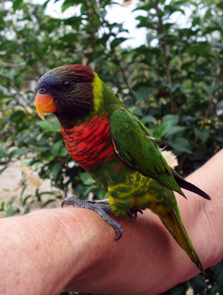
In the afternoon, we went for a walk. Glenys bought some local beans which were a strange shape like a star fruit in cross-section. We came across a Parakeet which one of the villagers has tamed, we've caught glimpses of them flying noisily overhead, so it was great to see one up close - such stunning colours. I gave some printed photographs to the two old guys who were the band at the Kastom dancing. They loved them. One guy disappeared into his wooden hut and brought out a beaten up photo album containing twenty or so photos of his family and insisted on telling me about every photograph - all of his three sons now live abroad. The other guy turned out to be the oldest guy on the island - a mere 93 years old.

There are three villages on the island each with 500 people, so there’s quite a population here. In between the villages is extensive bush containing coconut trees and the villager’s gardens, with pleasant dirt footpaths joining everything. We spent an enjoyable two hours walking around and chatting to people.
We invited “Caduceus” over for a beer or two.
11 June 2015 Uliveo Island to Port Sandwich, Malekula
It was a miserable overcast day with rain showers, but we decided to head off towards Banam Bay on the east coast of Malekula. High tide was at midday, so we hung around until eleven o’clock before tackling the sand bar out of the anchorage. The minimum depth that we saw was 3.8 metres.
There wasn’t much wind so we motor sailed out of the Maskelyns and then tried to sail for a couple of hours, but with an average speed of 2.8 knots and horribly sloppy seas, we grew tired of the crashing and banging of the sails and went back to motoring.
The swell was coming from the east and I became worried that the anchorage at Banam Bay might be rolly, so we cut our passage short and went into Port Sandwich, which is a long deep bay. We went three miles up the bay and anchored in an isolated anchorage near a wrecked ship on the west side of the bay. It was so peaceful, being surrounded by jungle and coconut trees, with one small hut just visible on the shore.
We managed to catch three small bonito on the way, so Glenys made Poisson Cru for dinner - fabulous.
12 June 2015 Port Sandwich to Ranon, Ambryn
We were up early and had breakfast while we motored out of the bay. I wish that we could stay and linger for a few days because it’s such a such a peaceful place, but we only have two more weeks here in Vanuatu before we have to do a 1,000 mile passage to the the Louisaides in Papua New Guinea and still have a lot to do in Vanuatu.

The wind picked up outside the bay and we found that we were on a close reach for the ten mile trip across the channel between Malekula and Ambyn. I’d put in our usual, cautious 1½ reefs in the main, but half way across we had over 25 knots, so I had to reef a bit more. Twenty minutes later, we came into the shadow of the Ambryn and the wind died completely.
We motored up the lee of the volcanic island and could clearly see the main active volcano which is called Mount Marum. The mountainous nature of the island meant that we soon had katabatic winds giving 35 knot gusts, so we rolled away all of the sails and motored the ten miles to Ranon.
The sea bed shelves slowly from over 100 metres deep and we anchored in 10 metres on black sand 50 metres off the beach. The village of Ranon is spread out along the shore and doesn’t look particularly attractive.
We went ashore and walked for 45 minutes up to the village of Fanla, which is a Kastom village where they put on ROM dances for tourists. There’s a dirt road which heads north along the edge of the shore and after about ½ mile, there’s a small path off to the right, which goes up steeply following a small gorge. We walked past it thinking that it led to someone’s garden, so had to walk a bit further and follow another dirt road that branched off ½ mile further on. (The small path is a shortcut back up to this road.)
As we walked into Fanla, we met a guy called Freddy, who said that he could arrange a ROM dance tomorrow. It’s going to cost us $50US each, but we agreed and arranged to be back at nine o’clock tomorrow. On the way back down, we started to have doubts about the whole thing… So the first guy that we meet in a village is able to organise this special dance for two people the very next day? There was nothing we could do about it - we’ll see what happens tomorrow.

Back on the boat, Glenys noticed that “Lil Explorers” had popped up on our AIS, so we contacted them and said that we’d meet up on Sunday. AIS is great and shows other boats within 20 miles, but I sometimes miss the mystery of arriving in an anchorage wondering who’s there.
It was a lovely clear night, so we had a fabulous display of stars with the red glow of the volcano over the island.
13 June 2015 Ranon, Ambryn
Our man Freddy met us on the beach, which was a bit of a surprise because we’d told him that we didn’t need a guide. Call me paranoid, but my first thought was that he was going to try to stiff us for a fee for guiding us up to Fanla. I was wrong though, he’d come down to go to the grocery store in Ranon and had waited to walk up with us.
Our doubts in his ability to organise the ROM dance soon faded because it turns out that Freddy is the brother of one of the chiefs in Fanla and he’s one of the few people allowed to make the traditional masks for the ROM Dance.
Fanla is a traditional Kastom village steeped in tradition and “Majick”. Having a volcano on the island gives great powers to sorcerers and Ambryn is the magic capital of Vanuatu. The men in the village go through a grading process over many years and have to perform various rituals to increase their grade, which seem to mostly involve killing pigs.
Most of the men have a large number of pigs - Freddy has 19. On some animals, they remove the top teeth to allow two of the lower teeth to grow abnormally in a six inch diameter circle. It takes five years to grow a complete circle and these “Tuskers” are greatly prized for grading rituals.

Many of the more powerful chiefs/sorcerers cook and eat their meals alone in tabu places, where women are not allowed to go. Freddie showed us around the village and pointed out a number of places that were tabu - one belonging to his father who is buried in the place where he used to prepare his meals.
The ROM dance was good - it's a traditional dance and ritual that is one of the levels in the grading process. Some of the dancers are dressed in large masks and costumes made from Pandanus leaves, while the others dance in the middle chanting and drumming, wearing only nambas (penis pouches). There were only four dancers in ROM masks, so I suspect that they were a little short-handed for our display, but it was enjoyable.
We walked back down to Ranon and spent the afternoon wilting in the heat with no wind. Our friends on Lil Explorers arrived after dark, so we’ll see them tomorrow.
14 June 2015 Ranon to Wali, Pentecost
It was a miserable night with shrieking gusts of wind howling down from the mountain making the boat veer around and heel over. Morning brought an overcast sky with light drizzle and we still had the gale-force katabatic gusts.
We went over to “Lil Explorers” to catch up on their travels since we last saw them in French Polynesia. They spent Cyclone season in Tonga, then went to US Samoa and from there headed here to Vanuatu. It was good to see them again, although slightly chaotic with their five children running about and plaguing each other.
After lunch, we decided that we didn’t want another night of these katabatic winds, so we upped anchor and set off on the 15 miles trip to Pentecost Island. I put 2½ reefs in the main and we pulled out the stay sail, which was just about right because we faced 35 knot gusts as we left the anchorage. As we cleared the island, the wind settled down to 25-30 knots and the waves weren’t too bad at 3 metres.
We dropped anchor just north of Wali, village. The anchorage is more of a road-stead being on a long straight beach. It’s sheltered from the main brunt of the prevailing south east winds, but there’s still some swell and wind waves bouncing us around a bit. Tomorrow we’ll go and look at the famous Land-diving tower, which inspired the current day bungee-jumping.
15 June 2015 Wali to Asanvari Bay, Maewo
I was up early, keen to go ashore to look at the Land-diving tower. Having pulled our dinghy up the steep pebble shore, we were met by Luke Fargo, who in 1978 was responsible for setting up land-diving in this village and making it accessible to tourists. Each year, the villagers build a 30 metre high wooden tower, tie thick vines around their legs and then dive from the tower.
Unfortunately, the land-diving only occurs on a Saturday and we’d just missed it. However, “Lil Explorers” had seen it a couple of days ago and have given us some video and photographs. Luke Fargo took us up a steep slope to the tower and told us all about it.

The activity only takes place in April, May and June because at any other time of year the vines do not have enough elasticity and would snap. This corresponds with the time of year best suited to plant yams and land-diving has become a ritual to ensure a good harvest of yams. Only men take part in the activity and there is a strict progression path with young boys starting at lower heights and progressing upwards over a period of years.
I was fascinated by the tower. It’s made from rough-hewn tree trunks and branches lashed together by small vines. The tower is perched on the edge of a steep slope and supported by thick vines leading to trees at the top of the slope. At each level of the tower there are small hinged platforms, which the flexible vines pass over. The platforms are supported by small sticks, which break when the vine becomes tight and acts as a shock absorber.
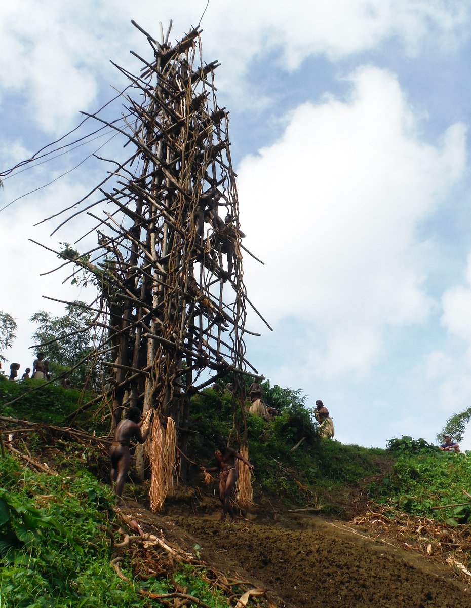
The vines are roughly one inch thick and there is one for each leg. The chief of the tower, who controls everything, determines how long the vine should be for each jumper. The perfect length is when their head just touches the ground - too long and they hit the ground and too short and they swing back into the tower. The landing area is at a slope of 45 degrees and is well dug over earth making a “landing” a little softer.
The video that “Lil Explorers” took shows how the dive ends abruptly - nothing like the slow gentle deceleration of the modern day bungee jump.
We were back on the boat by nine o’clock, so we headed north to Asanvari Bay on the next island of Maewo. Halfway along Pentecost, we were amazed to watch a swordfish leap out of the water only 20 metres to the side of our boat. It jumped three times in succession, flashing blue and silver in the sunshine and then with a final splash, disappeared - incredible.
The 35 mile passage was variable with hardly any wind for the first couple of hours; pleasant down-wind sailing in 15 knots for an hour; and then howling 35 knots katabatic gusts at the top of the island. The short 5 mile jump across the channel between islands was bouncy with 3 metre seas and 25-30 knot winds, so we were glad to arrive at the anchorage.
Asanvari Bay is a lovely sheltered harbour, just around the most southern headland of Maewo. It’s very deep and we had to motor around for a while to find a spot where we could anchor in 15 metres of water in some sand, but far enough away from the shallow reef surrounding the shore. There was only one other boat in the anchorage, but the wind swirls around and made it a challenge to know where their anchor was.

There’s a big waterfall ashore and guy called Alex has built a lovely little bar right next to it, so we went over for a couple of beers in the evening and met John and crew from “Wind Change” from Australia.
16 June 2015 Asanvari Bay, Maewo
We had a chill-out day. I caught up on my diary and photographs, then read a book and did some research about Indonesia. We’ve got very little information about the anchorages in Indonesia, so I need to get on the internet and download some blogs and maybe buy a cruising guide. I’ve had an email conversation with a British boat called “Spruce”, who are on the Sail Indonesia Rally, so I might be cheeky and get them to bring a few things out from Australia for us.
Glenys read a book and pottered about - she even got out some of the new shells in her collection and started taking photographs of them.
In the evening, we went over to the Sparkling Waters Bar and had a couple of beers. Alex only built the place two years ago and was hoping that he’d get 100 yachts a year, but last year there were only 50 turned up. He’s only had a few boats this year and is worried that Cyclone Pam will have put more people off coming.

Alex is still in the process of doing the finishing touches to the bar and the main problem he has is access from the anchorage. There’s a one metre tide here and the shoreline is all rocks and reef, so it’s a mission getting ashore and trying to stop your dinghy bashing into rocks all the time. Without using dynamite to make a channel, I’m not sure what the solution is.
While we were there, I spent twenty minutes sorting out Alex’s guitar. It’s a cheap Chinese model, which only had five strings and one of those was very rusted. I used a wire brush to clean the rust of the head mechanisms; oiled them and then replaced the two bass strings with some old strings from my guitar - it’s not perfect by any means, but at least it sounds a bit better.
We’ve finally run out of the wine that we bought in New Zealand, so the 60 bottles of duty free wine stored in our aft heads have been calling remorselessly. The customs have sealed the boxes with labels, but the glue on the labels is not very good and they peel off easily.
So, we’ve come up with a cunning plan to drink some of the bottles of wine with twist-off caps and then re-fill them with water mixed with black acrylic paint. We’re hoping that the customs officers will only give the bottles a quick glance (if they bother to inspect them at all). Hopefully, our little subterfuge will pass undetected and we won’t have Alba impounded and have to spend five years in a hell-hole of a jail.
17 June 2015 Asanvari Bay, Maewo
At seven o’clock, we were woken by a knocking on the hull. I staggered on deck to find a guy in a dugout canoe with a large bag of hot bread. Did I want some bread? Hell, yes! I bought a large loaf for $2 and collapsed back into bed.
After our decadent breakfast of fresh bread, boiled eggs and jam, we went ashore and were met by a nine year old girl called Lynn and two other small boys, who tagged along with us. We wandered about the village for ten minutes, but couldn’t find anyone. None of the children spoke any English, so we were a bit unsure where to go. Lynn saw our confusion and decided to lead us in a circular tour of the village, which is large and spread out.

Eventually we met a young lady called Lucy who told us that everyone had gone to a wedding in another village - all 200 people. She was a nurse and had stayed behind to deliver a baby that was expected today. Lucy acted as translator and we asked Lynn if she would guide us on a walk to the waterfall and then back.
The kids were great fun, looking after us and taking us along a narrow path to Alex’s bar. We indicated that we wanted to get above the waterfall, so Lynn decided that we’d climb up the edge of the waterfall, which was interesting. At the top of the waterfall, we came upon a path, so we headed right and climbed up towards another village.
On the way, the kids insisted on stopping off at a small grove of Cocoa trees to pick some pods. They then smashed them open on a rock and sucked the Cocoa seeds - there’s a bitter, lemony coating on the outside of the seeds - a natural sweet. We also saw Taro growing in flooded soil like a paddy field, around which flew brilliant red Dragonflies. (I later found out that the Taro is called Water Taro and is sweeter than normal Taro.)
After lunch, I went snorkelling around the headland to the south of the bay, but the reef was mostly rock with a small amount of hard coral and there was a strong current, so I soon gave up. As I went back into the edge of the bay, I came across a large pinnacle just off the shore, which was again rocky reef, but had a spectacular wall that dropped off to 30 or 40 metres. There were lots of large Snappers and other predatory fish swimming around on the outskirts of huge shoals of smaller fish - nice.
Back at boat, I had a look at our anchor chain, which was wrapped around a few coral heads. I’d tied a fender on the chain when we anchored, but it wasn’t in the correct place and had been dragged down to the sea bed at 15 metres, collapsing with the water pressure. Glenys pulled up 20 metres of chain and I tied two fenders higher on the chain at 35 metres. When Glenys let out chain to a total of 50 metres, it seems to better - the chain is now suspended above the coral heads.
18 June 2015 Asanvari Bay, Maewo
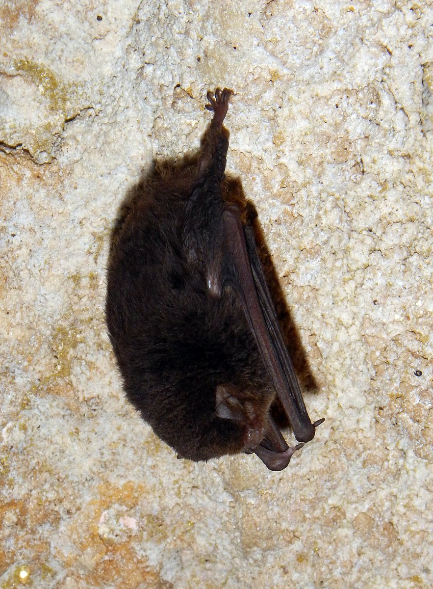
We’d arranged to go for a hike up to a bat cave and met Barry on the beach at nine o’clock. He led us along the path to Alex’s bar and then across the river at the bottom of the waterfall, following a faint path around the shore and then steeply up to his small village, where three families live in traditional huts.

Barry picked up his machete from his house and we were joined by his nine year old son, Hendry, who had decided that going for a hike was more fun than going to school. We walked up past the village’s pig pen, where we stopped to admire a couple of Tuskers owned by Barry’s uncle. The path gradually became more overgrown and steep as we headed along a ridge climbing up into the jungle.
Hendry slashed at the vegetation to clear a path, while we slipped and slithered on the mud, hanging onto trees and vines. After about an hour, we had a torrential down-pour and within minutes were soaking wet through. We plodded on for 2½ hours, wading through streams and walking through varied landscapes including coconut groves, temperate woodland and dense jungle with tree ferns.
The cave is large with an entrance measuring about 20 metres wide by 5 metres high. We turned on our torches and tentatively walked into the pitch-black cave, slipping and sliding, trying not to put our hands down on the thick, slimy bat guano on the rocks. The bats are tiny about 2 inches long. There were thousands of them clinging to the roof, hanging upside down and most of them didn’t seem to be too concerned by our torch beams.
After we’d walked a couple of hundred metres into the cave, we came across a huge hole where the cave roof has collapsed and we could see the sky. Below us was a chasm in the earth dropping down to another cave 50 metres below us. With bats swirling around us, we tossed rocks down in to the cavern, listening to the sound of the echoes. It sounded like the scene in The Hobbit movie where one of the hobbits drops a chain down into a well in the Mines of Moria - we were expecting orcs to come swarming out of the deep hole.

The walk back down the anchorage took 1½ hours, so we were tired and very muddy by the time that we arrived back at the boat at three o’clock. It was an excellent day out for only $10US each.
19 June 2015 Asanvari Bay to Aore Resort, Luganville, Santo
The alarm went off at 0450, so that we could sail 60 miles to Luganville. In the pitch black of night, I had a little bit of trouble getting the anchor up because the chain was caught under another coral head, but a few minutes of slowly motoring around soon cleared it.
We had 20-30 knots from the east and our course was almost straight downwind, so we didn’t bother with the mainsail and just ran with the genoa. This made it very easy to cope with the wind shifts on the few squalls that passed over us. Unfortunately, we had the topping lift too long and the boom was rubbing on the top of the bimini frame, which we didn’t notice until half way through the passage, by which time the boom had worn a hole through the Sunbrella - we’ll have to patch it now.
We arrived in Luganville at four o’clock and picked up a mooring off the Aore Resort. It costs $15US per night, but what the hell - the other anchorage on the mainland looks like it would be very rolly in the east winds that we have at the moment.
As a treat, we went ashore to have burger and chips at the hotel. It’s a very nice place with comfy chairs in the lounge area, tiled floors, cold beer, wireless internet and a swimming pool. After a couple of beers, we both had reality attacks, remembering that this is how the western world lives.
20 June 2015 Aore Resort, Luganville, Santo
The hotel provides a small ferry service to get guests to the mainland across the 1 mile channel. We caught the eight o’clock ferry and wandered to Immigration and Customs to see what we have to do when we clear out. Being a weekend both offices were closed.
There was a cruise ship in town, so the dirt road leading to the port was lined with small stalls selling lava lavas, t-shirts, shells and other souvenirs to the cruise ship passengers - we didn’t buy any. Instead, we walked to the vegetable market and checked out some of the supermarkets. There’s a very good supermarket called LCM, which has most of the stuff that we will need to stock up on before we leave here. We bought enough food to last us for a week and caught the ferry back to the resort.

After lunch on board, I went to the hotel lounge to do some internet work, trying to download information about anchorages in the Louisaides and Indonesia. Unfortunately, the hotel was very busy with local ex-pats who had come over from Luganville to escape from the cruise ship, so the internet was painfully slow.
21 June 2015 Aore Resort, Luganville, Santo
It was a Sunday, so we had a lazy day. I spent most of morning working out how to use a program called GE2KAP, which is brilliant utility that converts Google Earth images to KAP nautical charts that can be viewed in our OpenCPN chart plotter.
This is really useful for out-of-the-way anchorages, where our electronic nautical charts are often up to ¼ mile out of position - Google Earth images are said to be no more than 10 metres out of position. The KAP files don’t have any depth information, but by looking at the colour of the water, it’s pretty obvious where the shallow water and reefs are.
Yesterday, I was using Google Earth to look at various anchorages, which are now stored in the Google Earth cache. I was able to plot a route in OpenCPN that went over the anchorages that I was interested in and save it as a GPX route file. I then ran GE2KAP inputting the GPX route file. GE2KAP opens Google Earth; flies above the earth along the route, capturing the images and creating interlaced KAP nautical charts. There’s a great explanation of how to do it at http://svocelot.com/Cruise_Info/Equipment/KAPFiles.htm
At midday, we went ashore. The idea was to lounge by the pool, but it was overcast and drizzling, so we did the next best thing and went straight to the bar and ordered a couple of cold beers. We then had a fabulous meal and a bottle of wine - a perfect Sunday.
22 June 2015 Aore Resort to Beachfront Resort, Luganville
It was a horrible rainy day, so we waited for a lull in the rain and scurried across to an anchorage on the mainland next to the Beachfront Resort. The anchorage is okay, but I guess that it will be very rolly and choppy when the wind is strong from the south-east. The hotel is very yacht friendly with free internet and they charge a reasonable price for laundry ($8US per load).
We walked into town and did some serious food shopping and then caught a taxi back to the hotel for $2US. While in town, we visited the Customs office and found out that they probably won’t bother to inspect our duty free wine. This is good news because we’ve already drunk quite a few bottles, but we’ll fill up the empty bottles with black paint and water anyway, just in case we get a keen customs officer.

It was hot and humid in the afternoon, so we lurked about sweating. I dropped off 3 or 4 loads of laundry at the hotel then tried to use the hotel’s internet, but it was painfully slow. It’s a bit frustrating because I want to create a load of KAP files from Google Earth for the Louisiades and the first part of Indonesia.
23 June 2015 Beachfront Resort to Ratua Island, Santo
I nipped into the hotel to pick up our laundry and then we motored around to Ratua Island on the south side of Aore Island. There’s a small holiday resort here, who have installed two moorings, but they looked to be in a poor state of repair. We ignored the moorings and anchored in 14 metres of water away from the various reefs in a sandy patch. It’s a nice looking anchorage and we can pick up the Hotel’s wi-fi internet on the boat, so we’re happy here.
There’s another boat in the anchorage called “Dreamtime”, so we invited Neville and Catherine over for an evening beer or two.
24 June 2015 Ratua Island, Santo
Glenys repaired the dinghy cover, which had a worn patch where it rubs against the Hydrovane when the dinghy is lifted up on our davits. I’ve been attaching springs on the dinghy, but it still moves enough to wear a hole in the cover. In the afternoon, Glenys put a patch on the bimini, where the boom had worn it through.
I tackled the rod kicker, which was ripped off the mast a few weeks ago. I drilled the old rivets out of the mast and then tapped the holes for 8mm bolts. The mast is very thin, so there’s not much of a thread. I was worried that it’s not going to be strong enough, so I applied some adhesive sealant to the bracket before bolting it in place. There should be 12 bolts, but one of the holes was damaged when the bracket was ripped off and another one stripped as I was tightening it, so I have 10 bolts holding it in place. I’m not sure if it’s going to hold, but there’s nothing else that I can do here.

We took some time off jobs to go snorkelling and first tried a spot about ½ mile to the west of the anchorage where the reef sticks out from the coast. I was hoping that it could be a dive site, but the reef quickly runs out to sand and isn’t as steep as it looked on the chart. The snorkelling there wasn’t too good as the water was very choppy and murky. We went back to anchorage and picked up a mooring on the edge of the reef, which was much better.
25 June 2015 Ratua Island, Santo
We started to seriously think about when to leave Vanuatu and head to the Louisiades in Papua New Guinea, which is 900 miles away. Our plan was to leave early next week, but the weather forecast doesn’t look very favourable. There’s an area of unsettled weather to the north of us and it looks like it will spread south next week giving strong trade winds and then a trough - we might be here for a couple of weeks.
We spent most of the day using the internet to gather more information about the Louisiades, working out which islands to visit and which passes to use to get through the barrier reef surrounding the islands. We’ll only be there a week, so we want to make the most of our time there.
In the afternoon, we went for a snorkel on the south side of the island, but again it wasn’t too good. The seabed was mostly dead coral rubble with the odd live coral head sticking up. I spotted many Crown Of Thorns Starfish, which cause major damage to reefs by eating the coral polyps. These starfish produce millions of larvae, which grow in the coral rubble. If there are insufficient fish to eat all the larvae, then huge aggregations of starfish grow on the reef and decimate the coral. It’s a vicious circle because an unhealthy reef has less fish, so more starfish grow into adults.
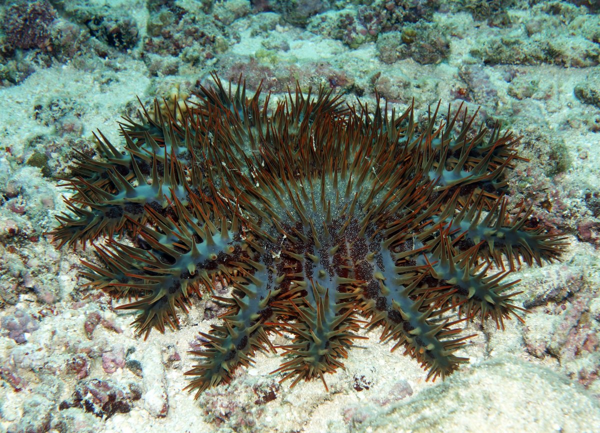
The Crown Of Thorns have poisonous spines all over their body and don’t have many predators. One of their predators is the Triton Trumpet mollusc, which is immune to the poison, but unfortunately the shell is very pretty and the locals catch the Triton’s to sell to tourists. The government here and in other Pacific countries have made it illegal to collect and sell the Triton shells, but we see them in practically every tourist souvenir shop.
In many places throughout the Pacific, dive operators actively kill Crown of Thorns starfish, by injecting them with a poison, to reduce their numbers and protect their reefs. I believe that these starfish can also be killed by collecting them in a large flour sack, then leaving them in the water for a day. The starfish need a flow of water over them, so die in the confines of a sack - they can then be tipped out to feed the fish. Perhaps I should start doing my bit.
26 June 2015 Ratua Island, Santo
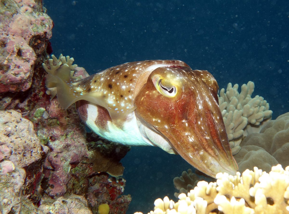
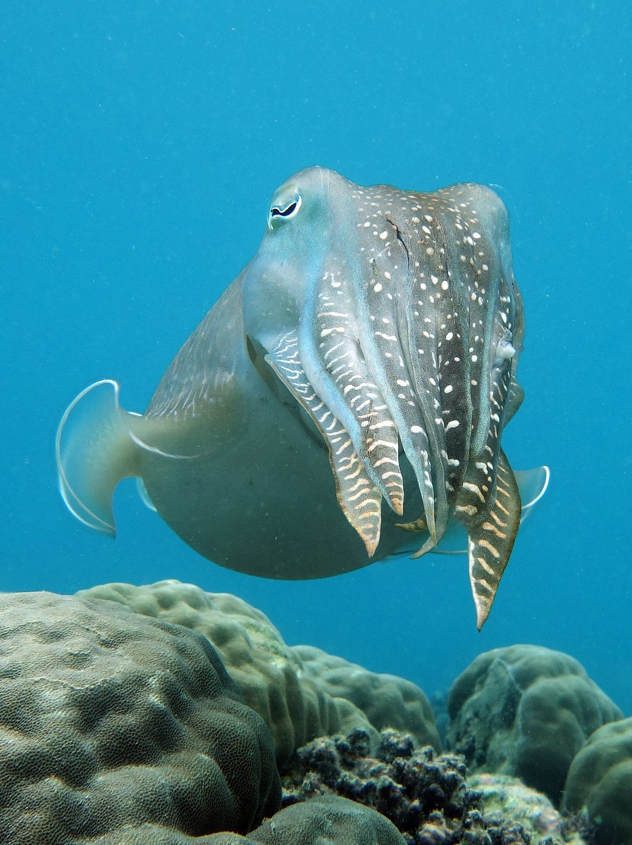
I pottered about in the morning and then went for a snorkel. I tied the dinghy to the buoy next to the anchorage and found a shoal of about eight Broadclub Cuttlefish. About 12 inches long, they were very large and seemed to be as curious about me as I was about them.

At first they kept their distance, but gradually edged closer. I found that if I dived down, hung onto a rock and stayed still, the cuttlefish would come near enough to allow me to take photographs. Unfortunately, there were a lot of particles in the water and I was getting “back-scatter” where the light from the flash gun is reflected back by the particles, causing white spots on the photograph. However, I spent an hour with the cuttlefish, trying different settings and positions and got a few reasonable photographs: photo 1 photo 2.
Glenys spent the day chilling out and even dragged out her ukuele.
27 June 2015 Ratua Island, Santo
We knuckled down and did some jobs. Glenys got out her sewing machine again and did some modifications to the bimini, then started to make some new larger side panels to keep the nasty rain out of the cockpit.
I removed the aft toilet pump and gave it a long overdue service. It’s an unpleasant job involving stripping it down and then scraping off a couple of years’ worth of stinky lime scale from all the components. Once I had it all clean, I replaced the various seals and we now have a smooth working toilet again.
It’s been a windy day with strong gusts and a little bit too cold to go snorkelling. It’s been good to have a rest from travelling for a few days, but we need to get moving onto Papua New Guinea, although neither of us relishes the thought of a seven day, 900 mile passage in these 25-30 knot winds.

28 June 2015 Ratua Island, Santo
I had a serious look at the weather forecast and downloaded two weeks’ worth of GRIB files. There’s a band of unsettled weather to the north west of us mostly over the Solomon Islands, which is caused by the South Pacific Convergence Zone (SPCZ). The GRIBS show that low pressure systems keep forming in this area, and then head south down over our route to the Louisiades, causing higher winds, squalls and rain.
Unfortunately, the forecast of the movement of these lows is unreliable and it’s hard to predict what we will encounter. Ideally, we would wait until the SPCZ calms down, but that might take weeks and we can’t wait that long. I tried to work out the best time to leave next week by looking at the weather each day along our route, but there doesn’t seem to be a perfect weather window.
It looks like we might have to leave in the middle of next week and take whatever comes, which is a bit depressing. On the positive side, the winds are constantly from the south-east, so with our north-west course, the winds will be directly behind us. On the downside, we’re likely to have a couple of days of squally weather with high winds and rain.
While I was muttering and moaning, Glenys finished off the new side panels for the bimini.
29 June 2015 Ratua Island, Santo
The unsettled weather north of the Solomons has now turned into a Tropical Depression, which is serious enough to have been given a number - TD17F. It’s heading south-west towards the Louisiades, so we won’t be leaving Vanuatu until that has dissipated.
We decided that we ought to go back to Luganville to get some food and to also see who else was around. Maybe some of the other cruisers might be heading in the same direction as us and we could compare notes on the weather.

It was just after low water, when we upped anchor and the tide was perfect - we had a 1 knot current with us around the south of Aore Island, then a 3-4 knot current with us through the narrow channel up the west side of the island, so the 15 mile trip was quick. The wind was blowing a hooley from the SSE, so we first went over to the Aore Resort, which is sheltered. Unfortunately, all the moorings were taken, so we had to go over to Beachfront Resort, which had a 30 knot onshore wind and breaking 2-3 foot waves in the anchorage - bloody horrible.
We anchored amongst eight other cruising boats, who were all gritting their teeth and coping. I didn’t want to leave the boat unattended, so I dropped Glenys off at the beach and she caught a taxi into town. While she was out, I went and chatted to Karen & Graham on “Red Herring”, who are also heading west to join the Sail Indonesia Rally. They were hoping to leave in the next couple of days like us, but are now waiting and watching the low.
Glenys was soon back on the beach with two cases of beer and enough meat to last two weeks. We both got wet through as we left the beach, bashing into the 2-3 foot waves. Back at the boat, we dumped the shopping in the cockpit, hauled the dinghy up on the davits and got the hell out of there, heading back to Ratua, which we know is a nice settled anchorage.
The tides were kind to us again and we had about a knot with us for most of the way, although we had a tough bash directly into the 30 knot winds when we turned the corner for the last three miles to the anchorage. What a difference. We anchored in 6 metres on white sand, surrounded by blue water and reef. The wind is still strong, but is moderated slightly by the island and we’re gently rocking as a little bit of swell sneaks around the corner - lovely.
Two hours after we arrived back, “Dreamtime” came back after their excursion to Luganville to extend their visas. They feel the same as us - why would anyone stay at the Beachfront anchorage?

30 June 2015 Ratua Island, Santo
At four o’clock in the morning, we were woken up by a very strange noise, which sounded like the white noise that you get from a radio when it’s between stations. We leaped out of bed and rushed into the saloon, but couldn’t find the source of the very loud noise. At first I thought that I’d left our stereo on, or it was a laptop, but everything was turned off. I went up on deck and couldn’t hear the noise - it was down below. Weird.
After a couple of minutes, the sound died off and then stopped. I checked the bilges, but they were dry. I checked the engine room - all looked okay. Mystified, we went back to bed. I lay there for an hour, trying to work out what the noise had been and the best explanation that I could come up with was an underwater volcanic eruption - so were we going to get a Tsunami? I didn’t sleep well. (Update - a month later, the mystery was solved when I found that the over-pressurisation disk on one of our dive tanks had burst - we’d heard the sound of high pressure air rushing out of the tank, buried deep in the cockpit locker.)
After my sterling efforts at servicing the aft toilet a few days ago, the damn thing stopped working yesterday. I found that the outlet pipe was blocked. This was strange because I’d changed the seacock in New Zealand and had also removed and unblocked the two inch diameter outlet pipes. I dived down to ensure that the skin fitting wasn’t blocked, then traced it to a valve in the outlet pipework. It took a few hours of grunting and groaning to remove the valve, clean it out and reinstall it.
Glenys continued working on the various rain protection panels. We now have panels that zip onto the bimini and cover the sides and back of the cockpit both at sea and in port. They’re much bigger than the old ones, so it will be difficult to see out when we’re at sea, so she’s currently sewing clear plastic windows in the side and aft panels - it’s turned into an epic job.
A couple more boats turned up today. “Deese” and “Red Herring” are both waiting for a weather window to sail to Indonesia, so we compared notes and the consensus is that TD17F is going to stall over the Solomons and intensify, so we’re all stuck here for the next few days.