
18 June 2015 Asanvari Bay, Maewo
We’d arranged to go for a hike up to a bat cave and met Barry on the beach at nine o’clock. He led us along the path to Alex’s bar and then across the river at the bottom of the waterfall, following a faint path around the shore and then steeply up to his small village, where three families live in traditional huts.

Barry picked up his machete from his house and we were joined by his nine year old son, Hendry, who had decided that going for a hike was more fun than going to school. We walked up past the village’s pig pen, where we stopped to admire a couple of Tuskers owned by Barry’s uncle. The path gradually became more overgrown and steep as we headed along a ridge climbing up into the jungle.
Hendry slashed at the vegetation to clear a path, while we slipped and slithered on the mud, hanging onto trees and vines. After about an hour, we had a torrential down-pour and within minutes were soaking wet through. We plodded on for 2½ hours, wading through streams and walking through varied landscapes including coconut groves, temperate woodland and dense jungle with tree ferns.
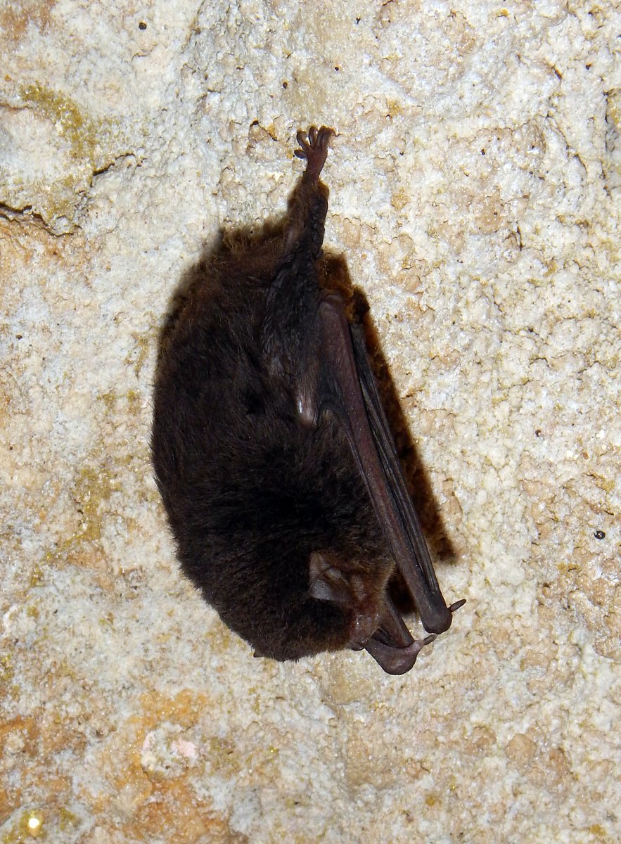
The cave is large with an entrance measuring about 20 metres wide by 5 metres high. We turned on our torches and tentatively walked into the pitch-black cave, slipping and sliding, trying not to put our hands down on the thick, slimy bat guano on the rocks. The bats are tiny about 2 inches long. There were thousands of them clinging to the roof, hanging upside down and most of them didn’t seem to be too concerned by our torch beams.
After we’d walked a couple of hundred metres into the cave, we came across a huge hole where the cave roof has collapsed and we could see the sky. Below us was a chasm in the earth dropping down to another cave 50 metres below us. With bats swirling around us, we tossed rocks down in to the cavern, listening to the sound of the echoes. It sounded like the scene in The Hobbit movie where one of the hobbits drops a chain down into a well in the Mines of Moria - we were expecting orcs to come swarming out of the deep hole.

The walk back down the anchorage took 1½ hours, so we were tired and very muddy by the time that we arrived back at the boat at three o’clock. It was an excellent day out for only $10US each.
19 June 2015 Asanvari Bay to Aore Resort, Luganville, Santo
The alarm went off at 0450, so that we could sail 60 miles to Luganville. In the pitch black of night, I had a little bit of trouble getting the anchor up because the chain was caught under another coral head, but a few minutes of slowly motoring around soon cleared it.
We had 20-30 knots from the east and our course was almost straight downwind, so we didn’t bother with the mainsail and just ran with the genoa. This made it very easy to cope with the wind shifts on the few squalls that passed over us. Unfortunately, we had the topping lift too long and the boom was rubbing on the top of the bimini frame, which we didn’t notice until half way through the passage, by which time the boom had worn a hole through the Sunbrella - we’ll have to patch it now.
We arrived in Luganville at four o’clock and picked up a mooring off the Aore Resort. It costs $15US per night, but what the hell - the other anchorage on the mainland looks like it would be very rolly in the east winds that we have at the moment.
As a treat, we went ashore to have burger and chips at the hotel. It’s a very nice place with comfy chairs in the lounge area, tiled floors, cold beer, wireless internet and a swimming pool. After a couple of beers, we both had reality attacks, remembering that this is how the western world lives.
20 June 2015 Aore Resort, Luganville, Santo
The hotel provides a small ferry service to get guests to the mainland across the 1 mile channel. We caught the eight o’clock ferry and wandered to Immigration and Customs to see what we have to do when we clear out. Being a weekend both offices were closed.
There was a cruise ship in town, so the dirt road leading to the port was lined with small stalls selling lava lavas, t-shirts, shells and other souvenirs to the cruise ship passengers - we didn’t buy any. Instead, we walked to the vegetable market and checked out some of the supermarkets. There’s a very good supermarket called LCM, which has most of the stuff that we will need to stock up on before we leave here. We bought enough food to last us for a week and caught the ferry back to the resort.

After lunch on board, I went to the hotel lounge to do some internet work, trying to download information about anchorages in the Louisaides and Indonesia. Unfortunately, the hotel was very busy with local ex-pats who had come over from Luganville to escape from the cruise ship, so the internet was painfully slow.
21 June 2015 Aore Resort, Luganville, Santo
It was a Sunday, so we had a lazy day. I spent most of morning working out how to use a program called GE2KAP, which is brilliant utility that converts Google Earth images to KAP nautical charts that can be viewed in our OpenCPN chart plotter.
This is really useful for out-of-the-way anchorages, where our electronic nautical charts are often up to ¼ mile out of position - Google Earth images are said to be no more than 10 metres out of position. The KAP files don’t have any depth information, but by looking at the colour of the water, it’s pretty obvious where the shallow water and reefs are.
Yesterday, I was using Google Earth to look at various anchorages, which are now stored in the Google Earth cache. I was able to plot a route in OpenCPN that went over the anchorages that I was interested in and save it as a GPX route file. I then ran GE2KAP inputting the GPX route file. GE2KAP opens Google Earth; flies above the earth along the route, capturing the images and creating interlaced KAP nautical charts. There’s a great explanation of how to do it at http://svocelot.com/Cruise_Info/Equipment/KAPFiles.htm
At midday, we went ashore. The idea was to lounge by the pool, but it was overcast and drizzling, so we did the next best thing and went straight to the bar and ordered a couple of cold beers. We then had a fabulous meal and a bottle of wine - a perfect Sunday.
22 June 2015 Aore Resort to Beachfront Resort, Luganville
It was a horrible rainy day, so we waited for a lull in the rain and scurried across to an anchorage on the mainland next to the Beachfront Resort. The anchorage is okay, but I guess that it will be very rolly and choppy when the wind is strong from the south-east. The hotel is very yacht friendly with free internet and they charge a reasonable price for laundry ($8US per load).
We walked into town and did some serious food shopping and then caught a taxi back to the hotel for $2US. While in town, we visited the Customs office and found out that they probably won’t bother to inspect our duty free wine. This is good news because we’ve already drunk quite a few bottles, but we’ll fill up the empty bottles with black paint and water anyway, just in case we get a keen customs officer.

It was hot and humid in the afternoon, so we lurked about sweating. I dropped off 3 or 4 loads of laundry at the hotel then tried to use the hotel’s internet, but it was painfully slow. It’s a bit frustrating because I want to create a load of KAP files from Google Earth for the Louisiades and the first part of Indonesia.
23 June 2015 Beachfront Resort to Ratua Island, Santo
I nipped into the hotel to pick up our laundry and then we motored around to Ratua Island on the south side of Aore Island. There’s a small holiday resort here, who have installed two moorings, but they looked to be in a poor state of repair. We ignored the moorings and anchored in 14 metres of water away from the various reefs in a sandy patch. It’s a nice looking anchorage and we can pick up the Hotel’s wi-fi internet on the boat, so we’re happy here.
There’s another boat in the anchorage called “Dreamtime”, so we invited Neville and Catherine over for an evening beer or two.
24 June 2015 Ratua Island, Santo
Glenys repaired the dinghy cover, which had a worn patch where it rubs against the Hydrovane when the dinghy is lifted up on our davits. I’ve been attaching springs on the dinghy, but it still moves enough to wear a hole in the cover. In the afternoon, Glenys put a patch on the bimini, where the boom had worn it through.
I tackled the rod kicker, which was ripped off the mast a few weeks ago. I drilled the old rivets out of the mast and then tapped the holes for 8mm bolts. The mast is very thin, so there’s not much of a thread. I was worried that it’s not going to be strong enough, so I applied some adhesive sealant to the bracket before bolting it in place. There should be 12 bolts, but one of the holes was damaged when the bracket was ripped off and another one stripped as I was tightening it, so I have 10 bolts holding it in place. I’m not sure if it’s going to hold, but there’s nothing else that I can do here.

We took some time off jobs to go snorkelling and first tried a spot about ½ mile to the west of the anchorage where the reef sticks out from the coast. I was hoping that it could be a dive site, but the reef quickly runs out to sand and isn’t as steep as it looked on the chart. The snorkelling there wasn’t too good as the water was very choppy and murky. We went back to anchorage and picked up a mooring on the edge of the reef, which was much better.
25 June 2015 Ratua Island, Santo
We started to seriously think about when to leave Vanuatu and head to the Louisiades in Papua New Guinea, which is 900 miles away. Our plan was to leave early next week, but the weather forecast doesn’t look very favourable. There’s an area of unsettled weather to the north of us and it looks like it will spread south next week giving strong trade winds and then a trough - we might be here for a couple of weeks.
We spent most of the day using the internet to gather more information about the Louisiades, working out which islands to visit and which passes to use to get through the barrier reef surrounding the islands. We’ll only be there a week, so we want to make the most of our time there.
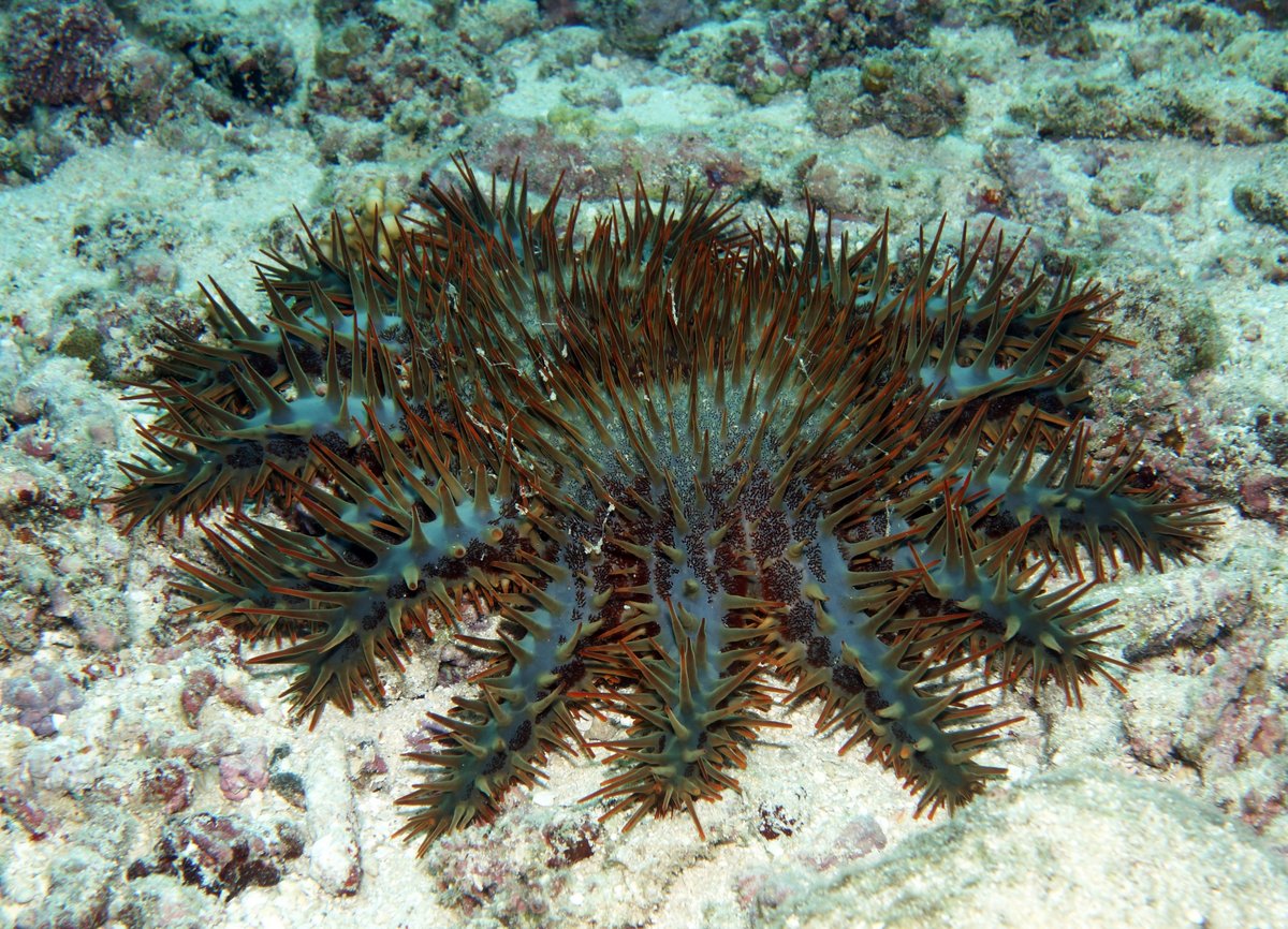
In the afternoon, we went for a snorkel on the south side of the island, but again it wasn’t too good. The seabed was mostly dead coral rubble with the odd live coral head sticking up. I spotted many Crown Of Thorns Starfish, which cause major damage to reefs by eating the coral polyps. These starfish produce millions of larvae, which grow in the coral rubble. If there are insufficient fish to eat all the larvae, then huge aggregations of starfish grow on the reef and decimate the coral. It’s a vicious circle because an unhealthy reef has less fish, so more starfish grow into adults.
The Crown Of Thorns have poisonous spines all over their body and don’t have many predators. One of their predators is the Triton Trumpet mollusc, which is immune to the poison, but unfortunately the shell is very pretty and the locals catch the Triton’s to sell to tourists. The government here and in other Pacific countries have made it illegal to collect and sell the Triton shells, but we see them in practically every tourist souvenir shop.
In many places throughout the Pacific, dive operators actively kill Crown of Thorns starfish, by injecting them with a poison, to reduce their numbers and protect their reefs. I believe that these starfish can also be killed by collecting them in a large flour sack, then leaving them in the water for a day. The starfish need a flow of water over them, so die in the confines of a sack - they can then be tipped out to feed the fish. Perhaps I should start doing my bit.