
22 September 2017 Nosy Antanimora to Nosy Saba, Madagascar
This stretch of coast is notorious for strong land breezes at night, which come from the south-east, so I had a restless night waiting for the wind to pick up and start bouncing us about. Fortunately, the wind was very light and we just had some choppy waves slapping on the side of the hull.

In the morning, there was a 5-8 knot land-breeze from the south-east, so knowing that the stronger sea-breeze wouldn’t kick in until midday, we went for a walk on the island, with the aim of climbing the 150 metre high hill. We walked through the village on the north-east side of the island, which is very tidy, but no one seemed to be interested in talking to us or pointing us to a path up the hill.
We found a path that led us past a well and towards the south-east beach where we’d landed the dinghy where we came across a group of buildings that turned out to be very low-key (empty) tourist accommodation. The guys here were a little more switched on and one walked with us for a few hundred metres to show us a path that ran south-west parallel to the beach. The path eventually climbed out of the bush and onto more open land, where we could see the hill, but within a few hundred metres we were back into dense bush.
Unfortunately, the indistinct paths seemed to be circumnavigating the hill, with no path leading up the hill (why would the locals want to go up there?). We dived into the bush and weaved our way steadily upwards. Eventually, we came out of the trees onto a 40-degree slope heading up the hill. It was covered with long grasses and ferns, with no sign of a trail, so I just headed up scrambling through the waist high vegetation, wondering if there were snakes on this island.
After a long and sweaty climb, we arrived at the top of the hill, which gave us a good view down to the anchorage. The hilltop was covered in long grass and no paths, so we headed down a ridge on the north side of the hill, through some more bush and found a path leading to the village. From there it was a quick walk around the beach back to the dinghy.
Back at the boat, we went for a swim and I snorkelled on the reef that was just under Alba. The water was murky, but the reef was in excellent condition with lots of sea life - I spotted a couple of Lionfish and a Swollen Phylidia. The fender on the chain was doing a fine job of keeping the chain clear of the reef.

By midday, the sea-breeze had started, so we upped anchor and had a pleasant three hour sail to Nosy Saba, where we anchored in 20 metres of water at 14°21.86S 047°38.75E. It’s an awkward place to anchor because the sea bed comes up steeply from 25 metres and there’s a fringing reef around the island that is very shallow.
We motored close into the reef and went along at 6 metres, which gave us a track on our chart plotter showing the reef edge. This lets us work out how close we can anchor without the risk of swinging into the reef overnight, when the wind is likely to switch and put us on a lee-shore. We had a quiet night.
23 September 2017 Nosy Saba to Nosy Lava, Madagascar
It was another calm night with no off-shore breeze. Past cruisers have reported strong south-east winds in this area at night, so we must be in an unusual weather pattern. There was no wind in the morning, so we went for a walk around the island, following a dirt track that circumnavigates and leads to the resort on the north-west corner.
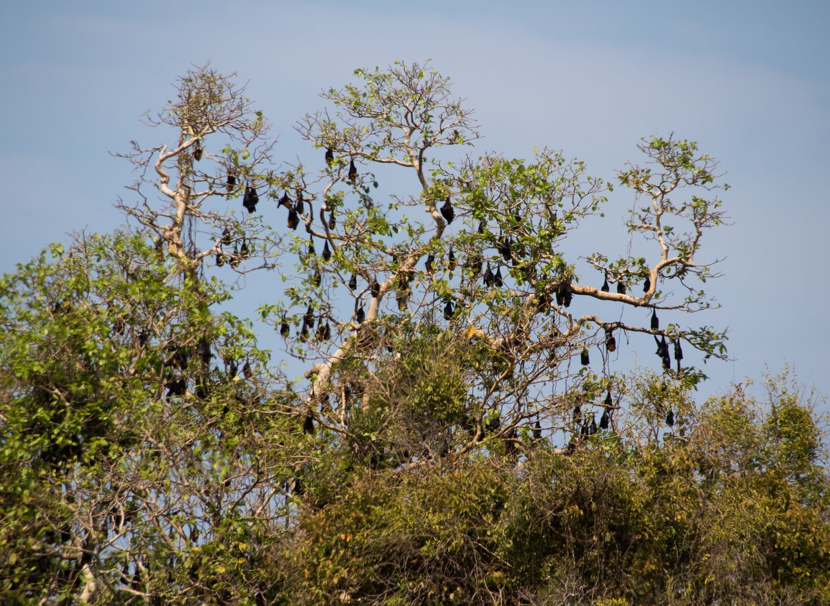
The island is about a mile in diameter and mostly arid apart form a small forest on the west side. We strolled through the resort and chatted to the manager, who told us that they have 26 bungalows, but had nobody staying at the moment - it seems that it’s a very quiet season. There was some interesting birds around including some very nervous guinea fowl, small green parrots and a few hawks. We also saw a large colony of Fruit Bats hanging in a tree.
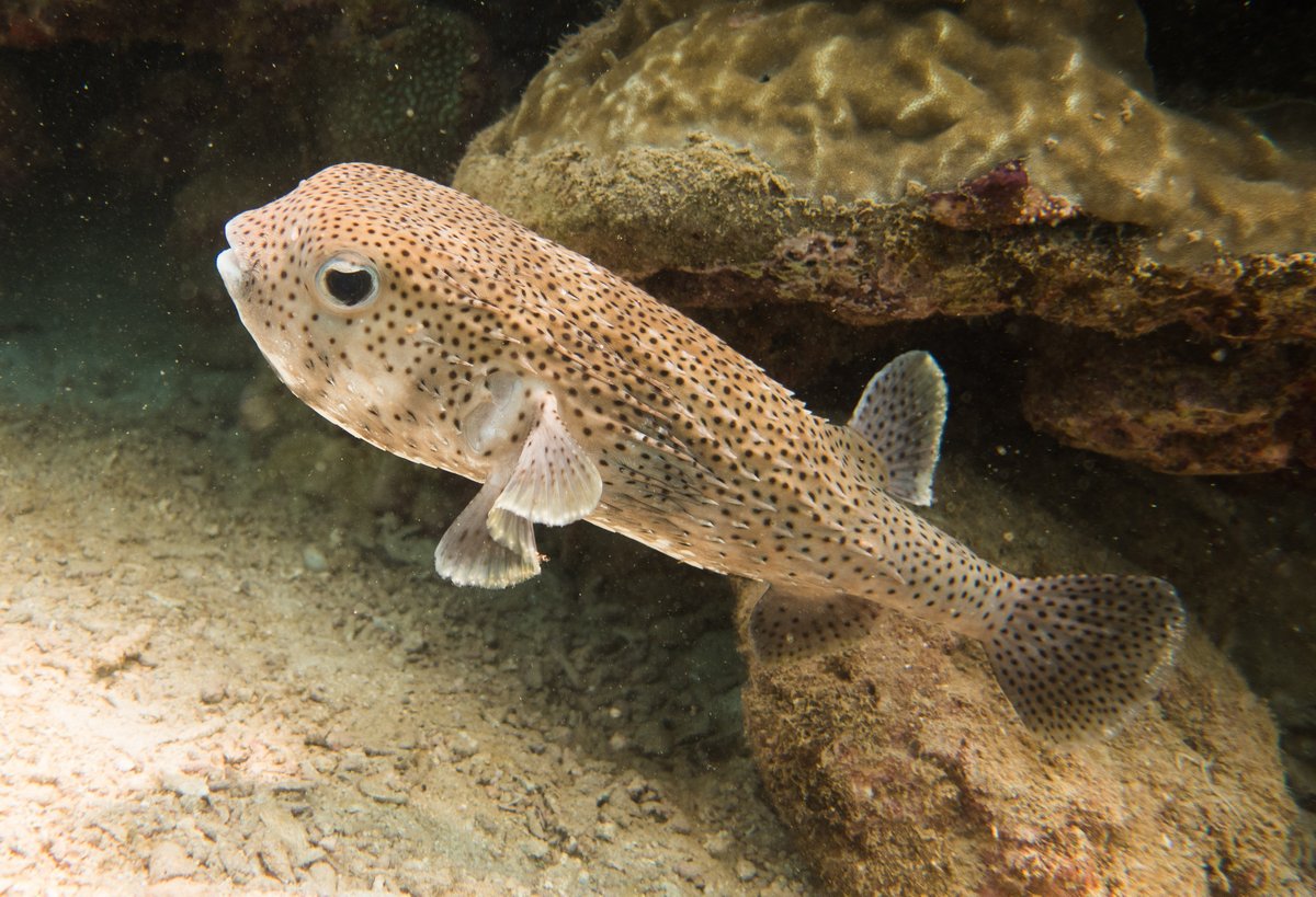
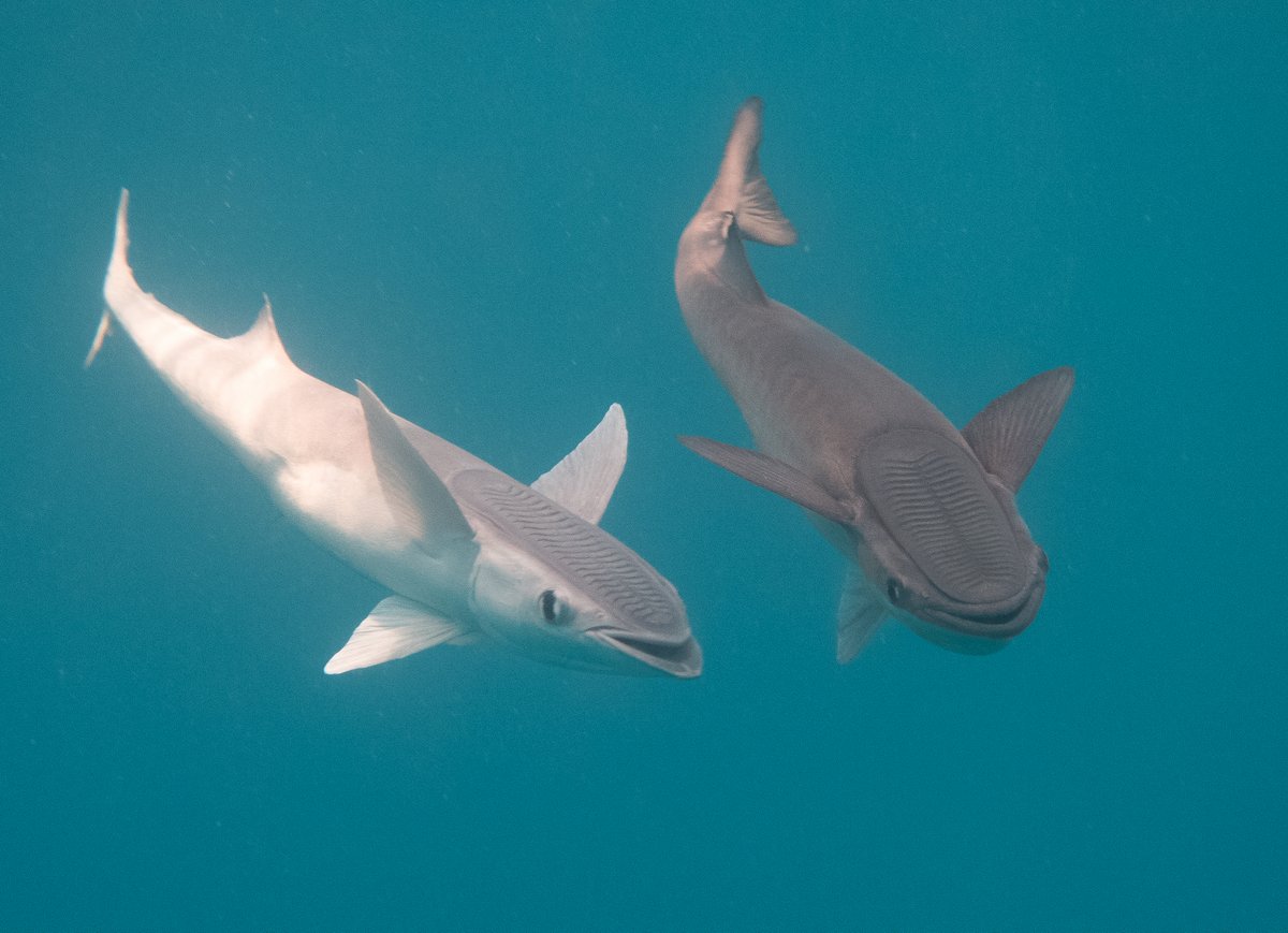
Back at the boat, we donned our wetsuits and went snorkelling on the reef by the anchorage, which was very good. The visibility was over 15 metres and the coral was very healthy. This would be the last snorkelling for a while, so we spent an hour there spotting lots of Skunk Anemonefish and a large Porcupinefish. When we returned to Alba, I spent fifteen minutes trying to photograph the five Remora who are living under our boat, but they are quick little devils.
Again, we left at midday and had a nice sail down to Nosy Lava. We initially anchored at 14°31.59S 047°36.48E in 6 metres in great holding sand, but the wind and persistent 1½ foot choppy waves were coming from the north, bouncing us about. “Red Herring” anchored further down the coast at 14°33.41S 047°37.81E, but they were still getting the chop. “Fortuna” and “Luna Blu” continued down to the south-east corner and found a place out of the wind waves, so we all herded down there.

Our final resting place was at 14°34.57S 047°37.39E in 12-14 metres of water. As usual, the reef came up sharply, but we appeared to be in good holding sand.
24 September 2017 Nosy Lava to Moramba Bay, Madagascar
With 35 miles to go to Moramba Bay, we left at 06:15, but there was very little wind. We motored for 30 minutes and then bobbed along in a light 5 knot wind while we ran the water-maker to top up our tanks. The wind then died completely, so we drifted around for a few hours waiting for the sea-breeze to arrive - Glenys played the ukulele and I caught up on my blog and editing photos.
I was able to get a brief internet connection, which was enough to download some GRIB files. It looks like there might be a good, long weather window on the 2nd October, which would enable us to start our passage down to South Africa. It’s too far in the future to have any certainty, but I think that we’ll be keeping a close eye on it from now on. It’s only 80 miles from Moramba Bay to Majunga where we will clear out, so I think that we’ll aim to get to Majunga on the 28th and then quickly onto Baly Bay to wait for the weather.
The wind finally picked up at 10:45 and we had a lovely sail as the wind freshened to 15 knots - it’s amazing how you can rely on the wind in this area. Glenys put out a fishing line and caught a nice Spanish Mackerel - fish for dinner!
We sailed into Moramba Bay and anchored at 14°53.23S 047°20.50E in 8 metres of water. There were already three boats in the anchorage, so we swelled the number to seven. It’s a lovely spot, so we’ll be staying for a few days.
25 September 2017 Moramba Bay, Madagascar
After all of our travelling for the last week, we had a quiet day on board pottering about. I spent most of the day doing research on the crossing to South Africa. We’re feeling a little apprehensive about the 1,200 mile passage because the weather systems come through every 3-5 days with the potential for strong southerly gales against the south-setting Mozambique Current, which can produce very steep and high seas.
I read various blogs and articles giving advice on the passage. The most common strategy (and the one that we will follow) is to head directly west from Cap St Andre towards the Mozambique coast. About 80 miles from the coast, we should encounter the Mozambique Current - a strong south setting current that will boost our passage speed.

As we head down the coast, we will be keeping an eye on the weather forecasts. If a southerly gale is forecast, there are three “bolt-hole” anchorages along the Mozambique coast, where we can go to hide until the bad weather passes. We can then hop 250 miles down to the next anchorage or, if the next weather window is long enough, go straight to Richards Bay. If you want to know more, I’ve concatenated all my research into one article called “Passage to South Africa”.
There looks to be a good weather window around the 3/4/5 October, so we’re going to stay one more day in Moramba Bay and then start heading down to Majunga to clear out.
In the evening, we were invited over to “Luna Blu” for sun-downers with “Red Herring”, “Continuum” and “Fortuna”. It looks like most of us are planning to sail down the Mozambique coast apart from “Red Herring”, who are thinking of going down the west coast of Madagascar and then making a 4-5 day passage across to Richards Bay.
26 September 2017 Moramba Bay, Madagascar
In the morning, we went ashore for a walk. We landed the dinghy on a deserted beach at the tip of the small peninsula, where there are some impressive Baobab trees. These trees have massive cylindrical trunks which can be up to 3 metres in diameter and the branches stick out at the top looking like roots, giving the tree the appearance of being upside down.

The trunk consists of a fibrous wood, which is used to store water and actually swells up in the rainy season. The Baobab tree is slow to grow and will live for several hundred years. Unfortunately, the Baobab tree is a critically threatened species in Madagascar, mostly due to the clearance of land.
We walked to a beach on the west side of the peninsula, where there is a very photogenic set of rocky islands made from (karst?) limestone and radically undercut by wave action. There’s an anchorage here, but it is exposed to the open sea and can be bouncy during the day and early evening, so we didn’t anchor there.
A lady called Bridget has a home on the beach and is planning to open a small restaurant and guest house there. While we chatted to her, we spotted a Coquerel Sifaka Lemur lurking up one of her trees. Bridget pointed us to a path that climbs up to the top of the little peninsula, which was a nice walk back to the dinghy.
We did some jobs in the afternoon. Glenys pulled out her sewing machine and repaired the dingy cover. A few patches were needed and the thread had perished on some of the seams.
I had another look to see if I could find the water leak on the engine. About ten days ago, I found a couple of litres of water in the engine bilge, but since then we’ve only been getting a few tablespoons of water, if anything. I can’t be 100% sure where it’s coming from, but there were some salt deposits below the sea water pump, so I’ve cleaned everything off and see if the salt deposits reappear. I checked my spares and thankfully, I have some spare bearings and seals for the pump, so if the pump fails completely, I’ll be able to repair it.
Later in the afternoon, I sewed an extra piece of webbing onto the tack of the staysail. There were two pieces of webbing, but one has perished in the sun. It was a mission sewing through 12mm of webbing and sail cloth, but our “Speedy Stitcher” once again handled the job.
27 September 2017 Moramba Bay to Mahajanga Bay, Madagascar
High tide was at 08:30, so we waited until 09:00 before we upped anchor, so that we could ride the out-going tidal current. Unfortunately, the off-shore land breeze wasn’t very strong today and we had to motor most of the way out of the estuary. By 09:30, we were in clear water, so we ran the water maker for an hour to make sure that our water tanks were full.

The sea-breeze picked up just before midday and we slowly sailed along with just our mainsail up. We only had 20 miles to go and the anchorages in Mahajanga Bay are renowned for being rolly, so there was no point in getting there too early.
“Luna Blu” and “Fortuna” were also moving south today and there was much discussion on the VHF radio about continuing on past Mahajanga Bay and anchoring on the coast further towards Majunga. We prevaricated - anchoring on the coast would be an open roadstead, with the on-shore sea-breeze making it an unpleasant place until late in the evening. We eventually decided to go into Mahajunga Bay and make an early start for the 65 mile passage to Majunga tomorrow.
At about 16:00, we anchored in Mahajamba Bay at 15°14.16S 046°57.84E in 8 metres of water. The wind and swell were coming from the north-west and we tucked in behind a bit of a sandy headland, which made it a fairly calm anchorage. We had 3 foot wind waves as we crossed the mouth of the estuary, so I wouldn’t have wanted to be on the east side of the bay. There’s large fishing camp ashore, which tells me that this is a good place to be.
28 September 2017 Mahajanga Bay to Katsepy, Madagascar
We had a very peaceful night until 03:00, when the wind picked up from the south-east causing some chop. We were planning to leave at 04:00, but both of us were awake at 03:00, so we dragged ourselves out of bed and left. We had a great sail along the coast in steady south-east winds allowing us to make 6-7 knots.
For the past couple of weeks, we’ve had a clunking sound coming from the propeller shaft, which starts as soon as our boat speed is above 6 knots. We have a fixed 3-blade propeller, which we allow to rotate as we’re sailing along. I’ve proved that the clunking sound is coming from the propeller by putting the gearbox in reverse while we are sailing - the noise stops when the propeller is not turning.

I’m pretty sure that the noise is caused by a worn cutlass bearing, which supports the propeller shaft near to the propeller and the shaft is “rattling” in the worn bearing. I thought that maybe the propeller was out of balance because we had a worn zinc on the end of the shaft, so we pulled over and anchored off the coast for 30 minutes, so that I could dive down and have a look.
The propeller is still firmly fixed to the propeller shaft and everything looked okay. The zinc was badly worn, so I removed it completely. Unfortunately, the rattling noise returned when we were back underway. It’s very, very annoying, but at least I know that the rudder and propeller are not falling off…
As we entered the Majunga Estuary, hundreds of Dhows were sailing in from their day’s fishing. They were running downwind and we were on a close reach, cutting across their path, so we had an enjoyable hour, dodging through the middle of the fleet, waving, laughing and taking lots and lots of photographs. It’s an impressive sight to see these small boats with huge sails screaming along in 20 knot winds.
We arrived in Katsepy at 15:30 and anchored at 15°46.11S 046 14.72E in 7 metres. “Luna Blu” and “Fortuna” had just arrived. They anchored off the coast last night and had a sleepless, rolly night until it calmed down after midnight.
Glenys and I jumped in our dinghy to go and have a look at what was available on Katsepy - we were interested in vegetables and diesel. The village is a score of shops and buildings on sandy streets. There were a few dreary looking vegetables for sale and a couple of small grocery stores, but the majority of the shops were selling food and snacks for the people who come here to catch a ferry across to Majunga.

A previous cruiser had reported a fuel station 200 metres along the road, but when we asked in the village, we were pointed to a small shop selling petrol in plastic water bottles and diesel in cooking oil drums. I didn’t like the look of that and even if there was a fuel station along the road, there didn’t seem to be any tuk-tuks in the village to transport our jerry jugs, so we didn’t investigate any further. We’ll get fuel and provisions when we go into Majunga city to clear out tomorrow.
Back on board, I looked at the engine. I found a few tablespoons of water in the engine bilge and salt crystals beneath the sea water pump, so it’s leaking. I’m not sure whether to leave it until we get to South Africa or whether to bite the bullet and try to change the seal before we leave.
My final job was to pour the diesel from our three jerry cans into the main tank, so that we can get diesel tomorrow. The fuel tank is full, so we will have enough fuel to motor 1,000 miles of the 1,200 mile passage to South Africa - if we have to.
29 September 2017 Katsepy, Madagascar
I was out of bed at 05:00. I couldn’t sleep because I was worrying about the sea water pump. The big danger of trying to repair it myself was breaking something, not being able to take it apart or put it back together. My only chance of getting engineering help or importing new pump was in Majunga. So my middle-of-the-night logic was that if I left the pump alone, then the seal may fail completely while on the 1,200 mile passage to South Africa. If I was going to repair it myself then I needed to do it before we cleared out. I decided to do it now - hence my early morning start.

It took me 30 minutes to remove the pump and then 30 minutes to pull it apart. I had a few tense moments. The drive pully wouldn’t come off the pump shaft - I was desperately trying not to damage anything, but after a little perseverance with a gear puller, it popped off the taper. The next trauma was getting the shaft out of the pump body. My pullers didn’t work, so I eventually I took a deep breath and gave it a good smack with a nylon mallet and thankfully it came out.
The lip seal was obviously in bad condition and need to be replaced, but worst was that one of the two bearings was badly corroded. I could still turn the shaft by hand, but it was sticky and unsmooth. It tentatively tried to knock the bad bearing out, but it felt like it wasn’t going to come out easily, so I decided to leave it in place and just replaced the damaged lip seal.
When I put it all back together, with a new impellor, it turned ok, so I think that it will be good enough to get me to South Africa, where I can get it serviced properly. This was so traumatic to my mental health that I’m going to buy a new pump in and carry the old one as a spare - much easier to just change the water pump assembly.
I’d finished the job by the time that Glenys dragged herself out of bed at 06:45. I ran the engine for fifteen minutes and all seems to be good. Phew!
After a quick breakfast, we pulled up the anchor and sailed the six miles across to Majunga city. We initially tried to anchor at 15 43.80S 046 18.44E in 8 metres, which is next to the main port. The plan was to leave our dinghy on a concrete ramp at 15 43.56S 046 18.38E, which is near the main port. Unfortunately, there was a 20 knot wind howling from the east, causing 3 foot waves and after dragging once in the soft mud, we decided not to leave our home there.

Instead we motored around to a breakwater where we anchored in 7 metres at 15°42.90S 046°17.80E. The holding appeared to be soft mud - we were slowly ploughing backwards with our engine at a stump-pulling 2000 revs. However, it was a very sheltered anchorage, so we risked it. The other four boats arrived shortly after us.
We pulled our dinghy up onto a small beach at 15 42.69S 046 18.10E, where there are a number of local wooden boats pulled up on the beach. A couple of people helped us trundle our dinghy up to a palm tree around which we wrapped chain. Our helpers wanted to guard our dinghy, so we chose a middle aged lady who appears to live in a shack on the beach. Everyone was very helpful and helped carry our three jerry cans up to the main road, where we caught a tuk-tuk.
I showed the driver a photograph of the sign for the “Agence Portuaire, Maritime et Fluviale” (Port Captain) and he seemed to know where to take us. I had used Google Maps on my phone to work out the location of the Port Captain and Immigration, but the tuk-tuk driver went straight past the Port Captain and took us to the main port, which was okay because that’s where the Immigration office is located. (15°43.60S 046°18.65E).
We wandered in through the port gate and a guy directed us to Immigration, who were very pleasant, put exit stamps in our passports and charged us 40,000 Ariary (£10). He gave us a small receipt, but shoved the money into his pocket - Hmmm! (Our friends on “Wairima” were charged 20,000 Ariary and “Luci” was charged 30,000 Ariary, so who knows if the charge is official or not...)

Lugging our empty diesel jerry jugs, we walked ½ mile back to the Port Captain at 15°43.64S 046°18.27E. It was an interesting walk, which took us past the small cargo boat dock, which was bustling with wooden boats unloading a wide variety of cargo. The Port Captain’s office was very nice and the staff efficiently produced an outward clearance document and relieved us of 35,000 Ariary (£8). They didn’t want to see any other Madagascan documentation, so I guess that we could have obtained our port clearance without paying Immigration.
Flushed with success, we hailed another tuk-tuk to take us to the Leader Price supermarket. After leaving our empty jerry cans with the bag security guy, I left Glenys in the air-conditioned store and went out looking for an ATM. Majunga town is a scruffy, dusty place with a few nice colonial buildings, but it’s mostly rundown, concrete buildings. The preferred mode of travel appears to be tuk-tuks, but there are also many two person rickshaws around, being pulled by fit young men running along the road, often in bare feet.
I withdrew enough cash to allow us to buy 60 litres of diesel and returned to the supermarket. Glenys only needed to buy enough food to last for a couple of weeks, so we were soon climbing into another tuk-tuk, who took us to a petrol station, waited for us and then dropped us back at the beach with our dinghy. The going price for a tuk-tuk ride seems to be 1,500 Ariary (£0.37) per person per trip, but we still had some Ariary notes left, so I gave the guy 10,000 Ariary (£2.50), so he was well chuffed.
Our lady guard helped us launch the dinghy and I gave her 5,000 Ariary (£1.25), so she was really happy. We were back on the boat by 12:00 - an efficient operation, run with military precision.

After lunch, we chilled out for a while and waited until the afternoon breeze picked up at 14:30 before we sailed back to Katsepy. Once again, the Dhows were sailing back to port on the sea-breeze - hundreds of them scattered across the horizon, it’s a fabulous sight.
After a long busy day, we collapsed into bed at 20:00.
30 September 2017 Katsepy to Baly Bay, Madagascar
The alarm went off at 03:00 and we were soon on our way, sailing the 70 miles to Baly Bay. It was very dark, but we only saw a couple of fishing boats, which was a relief. The wind was behind us for most of the way, so I poled out the genoa to port and we made good time.
The wind dropped for an hour in the late morning, so we ran the water maker for an hour to fill up our water tanks. I’m not using the low pressure pump, so the high pressure pump is sucking the sea water up through the filters and is also sucking in air somewhere. I had to stop the pump several times to vent the air out of the filters, which was a damn nuisance. I’m going to re-plumb the whole system in South Africa - my job list is getting longer.
We arrived in Baly Bay at 15:30 and anchored at 16°03.42S 045°17.64E in 5 metres for the night next to “Wairima”. We invited Alan and Vicky over for a beer and caught up on the gossip. They’ve been here for five days and are planning to leave tomorrow night, which is a little early for us.
There are more photos in our Photo Album section.
- << Prev
- Next